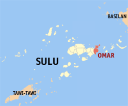
Omar, Sulu
| Omar | |
|---|---|
| Municipality | |
 Map of Sulu with Omar highlighted | |
.svg.png) Omar Location within the Philippines | |
| Coordinates: 05°59′N 121°24′E / 5.983°N 121.400°ECoordinates: 05°59′N 121°24′E / 5.983°N 121.400°E | |
| Country | Philippines |
| Region | Autonomous Region in Muslim Mindanao (ARMM) |
| Province | Sulu |
| District | 2nd district of Sulu |
| Established | December 20, 2005 |
| Barangays | 8 |
| Government[1] | |
| • Mayor | Ferhana Mohammad |
| Population (2010)[2] | |
| • Total | 18,098 |
| Time zone | PST (UTC+8) |
| ZIP code | 7404 |
| Dialing code | 68 |
| Income class | 6th |
Omar is a sixth class municipality in the province of Sulu, Philippines. In the 2010 census, it has a population of 18,098 people.[2]
It was created out of the 8 barangays of Luuk, by virtue of Muslim Mindanao Autonomy Act No. 194, which was subsequently ratified in a plebiscite held on July 18, 2007.[3]
Barangays
Omar is politically subdivided into 8 barangays.[2]
- Andalan
- Angilan
- Capual Island
- Huwit-huwit
- Lahing-Lahing
- Niangkaan
- Sucuban
- Tangkuan
Demographics
| Population census of Omar | ||
|---|---|---|
| Year | Pop. | ±% p.a. |
| 2007 | 25,102 | — |
| 2010 | 18,098 | −11.22% |
| Source: National Statistics Office[2] | ||
References
- ↑ "Official City/Municipal 2013 Election Results". Intramuros, Manila, Philippines: Commission on Elections (COMELEC). 1 July 2013. Retrieved 5 September 2013.
- ↑ 2.0 2.1 2.2 2.3 "Total Population by Province, City, Municipality and Barangay: as of May 1, 2010". 2010 Census of Population and Housing. National Statistics Office. Retrieved 27 August 2014.
- ↑ MMA Act No. 194 : An Act Creating the Municipality of Omar in the Province of Sulu
External links
- Basilan, Sulu Have 5 New Towns
- Memorandum Order No. 260
- Philippine Standard Geographic Code
- Philippine Census Information
- Omar Sulu Map
- Local Governance Performance Management System
 |
Sulu Sea |  | ||
| Luuk | |
Banguingui | ||
| ||||
| | ||||
| Celebes Sea |
| ||||||||||