Omaha–Council Bluffs metropolitan area
The Omaha–Council Bluffs metropolitan area is a metropolitan area comprising the cities of Omaha, Nebraska, and Council Bluffs, Iowa, and surrounding areas. The area has a population of 904,421 (2014).[1] The metropolitan area, as defined by the Office of Management and Budget, consists of eight counties – five in Nebraska and three in Iowa.[2][3] The area is locally referred to as "the Metro Area", "the Metro", or simply "Omaha". Three of the counties have large urban areas; the other five counties consist primarily of rural communities, most of which have populations of 1,000 or less.
Historical definitions and populations
| Historical population |
| Census | Pop. | | %± |
| 1950 | 366,395 | | — |
| 1960 | 457,873 | | 25.0% |
| 1970 | 540,142 | | 18.0% |
| 1980 | 585,122 | | 8.3% |
| 1990 | 618,262 | | 5.7% |
| 2000 | 767,041 | | 24.1% |
| 2010 | 865,350 | | 12.8% |
| Est. 2014 | 904,421 | | 4.5% |
| [4] |

View from space of Omaha and Council Bluffs
Standard definitions for United States metropolitan areas were created in 1949; the first census which had metropolitan area data was the 1950 census. At that time, the Omaha–Council Bluffs metropolitan area comprised three counties: Douglas and Sarpy in Nebraska, and Pottawattamie in Iowa. No additional counties were added to the metropolitan area until 1983, when Washington County, Nebraska was added. Cass County, Nebraska was added in 1993; Saunders County in Nebraska and Harrison and Mills counties in Iowa became part of the Omaha–Council Bluffs metropolitan area in 2003.
The 2003 revision to metropolitan area definitions was accompanied by the creation of micropolitan areas and Combined Statistical Areas. Fremont, in Dodge County, Nebraska, was designated a micropolitan area. The Omaha–Council Bluffs–Fremont combined statistical area has a population of 858,720 (2006 estimate).[5]
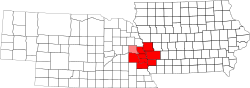
Components of the Omaha–Council Bluffs metropolitan area
Counties
Nebraska
Iowa
Cities
Primary city
- Omaha – 408,958 inhabitants (2010)
Cities of 10,000 people or more
Cities of 5,000 to 10,000 people
Cities of 1,000 to 5,000 people
- Arlington – 1,197 inhabitants
- Ashland – 2,453 inhabitants
- Avoca (Iowa) – 1,610 inhabitants
- Carter Lake – 3,785 inhabitants
- Dunlap – 1,139 inhabitants
- Eagle – 1,105 inhabitants
- Gretna – 4,441 inhabitants
- Logan – 1,545 inhabitants
- Louisville – 1,106 inhabitants
- Malvern – 1,256 inhabitants
|
|
Cities and villages with fewer than 1,000 people
Census-designated places
Population information
| Omaha–Council Bluffs metro in order of population |
|---|
| County |
Population |
| Douglas County, Nebraska |
517,310[6] |
| Sarpy County, Nebraska |
158,840[6] |
| Pottawattamie County, Iowa |
90,218[7] |
| Cass County, Nebraska |
25,241[6] |
| Saunders County, Nebraska |
20,780[6] |
| Washington County, Nebraska |
20,234[6] |
| Harrison County, Iowa |
15,745[8] |
| Mills County, Iowa |
15,595[9] |
Annexations of formerly incorporated places by the City of Omaha
Notes
- ↑ Henry J. Cordes. "For the Omaha metro area, population milestone of 1 million is in sight". Retrieved March 26, 2014.
- ↑ Hunzeker, S. "Nebraska Metro & Micro Statistical Areas", Nebraska Department of Labor. Retrieved September 5, 2008.
- ↑ "May 2007 OES Metropolitan and Nonmetropolitan Area Definitions." Bureau of Labor Statistics. Retrieved September 5, 2008.
- ↑ "Metro population hits 865,350". Omaha.com. Retrieved 2011-03-06.
- ↑ Iowa Data Center. "Population Estimates and Components of Population Change for Iowa's Combined Statistical Areas (2003 Definition): 2000–2006" (PDF). Retrieved April 6, 2007.
- ↑ 6.0 6.1 6.2 6.3 6.4 "Metro population hits 865,350". Omaha.com. March 1, 2011. Retrieved October 29, 2011.
- ↑ "Pottawattamie County Quick Facts", US Census Bureau. Retrieved August 25, 2008.
- ↑ "Harrison County Quick Facts", US Census Bureau. Retrieved August 25, 2008.
- ↑ "Mills County Quick Facts", US Census Bureau. Retrieved August 25, 2008.
External links
|
|---|
| | |
- New York
- Los Angeles
- Chicago
- Washington
- San Jose
- Boston
- Dallas
- Philadelphia
- Miami
- Houston
- Atlanta
- Detroit
- Seattle
- Phoenix
- Minneapolis
- Cleveland
- Denver
- San Diego
- Portland OR
- Orlando
|
- St. Louis
- Tampa
- Pittsburgh
- San Juan PR
- Sacramento
- Charlotte
- Kansas City
- Salt Lake City
- Columbus OH
- Indianapolis
- Las Vegas
- San Antonio
- Cincinnati
- Milwaukee
- Raleigh
- Nashville
- Austin
- Virginia Beach
- Greensboro
- Jacksonville
|
- Hartford
- Louisville
- New Orleans
- Grand Rapids
- Greenville
- Memphis
- Oklahoma City
- Birmingham
- Richmond
- Harrisburg
- Buffalo
- Rochester
- Albany
- Albuquerque
- Tulsa
- Fresno
- Knoxville
- Dayton
- El Paso
- Tucson
|
- Cape Coral
- Honolulu
- Chattanooga
- Omaha
- North Port
- Columbia
- Little Rock
- McAllen
- Bakersfield
- Madison
- Baton Rouge
- Modesto
- Des Moines
- Syracuse
- South Bend
- Boise City
- Charleston WV
- Lexington
- Charleston SC
- Springfield MA
|
- Huntsville
- Spokane
- Wichita
- Jackson
- Colorado Springs
- Youngstown
- Toledo
- Portland ME
- Fort Wayne
- Lakeland
- Lafayette
- Mobile
- Visalia
- Reno
- Augusta
- Scranton
- Palm Bay
- Fayetteville NC
- Lansing
- Springfield MO
|
| | |
|
Coordinates: 41°15′35″N 95°55′18″W / 41.25972°N 95.92167°W / 41.25972; -95.92167