Olive Township, St. Joseph County, Indiana
| Olive Township | |
|---|---|
| Township | |
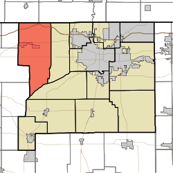 Location in St. Joseph County | |
| Coordinates: 41°41′07″N 86°28′17″W / 41.68528°N 86.47139°WCoordinates: 41°41′07″N 86°28′17″W / 41.68528°N 86.47139°W | |
| Country |
|
| State |
|
| County | St. Joseph |
| Government | |
| • Type | Indiana township |
| Area | |
| • Total | 57.5 sq mi (148.93 km2) |
| • Land | 57.4 sq mi (148.65 km2) |
| • Water | 0.11 sq mi (0.28 km2) 0.19% |
| Elevation | 738 ft (225 m) |
| Population (2000) | |
| • Total | 3,914 |
| • Density | 68.2/sq mi (26.3/km2) |
| ZIP codes | 46552, 46554, 46619, 46628 |
| GNIS feature ID | 0453688[1] |
Olive Township is one of thirteen townships in St. Joseph County, Indiana, United States. As of the 2000 census, its population was 3,914.[2]
Geography
According to the United States Census Bureau, Olive Township covers an area of 57.5 square miles (149 km2); of this, 57.4 square miles (149 km2) (99.81 percent) is land and 0.11 square miles (0.28 km2) (0.19 percent) is water.
Cities, towns, villages
Unincorporated towns
- Hamilton at 41°43′56″N 86°28′41″W / 41.732268°N 86.478073°W
- Hubbard at 41°41′47″N 86°25′08″W / 41.696435°N 86.418903°W
- Olive at 41°42′00″N 86°26′53″W / 41.700046°N 86.448071°W
- Terre Coupee at 41°42′08″N 86°28′38″W / 41.702268°N 86.477239°W
- Zeigler at 41°41′54″N 86°26′01″W / 41.698379°N 86.433626°W
(This list is based on USGS data and may include former settlements.)
Adjacent townships
- Bertrand Township, Berrien County, Michigan (northeast)
- Warren Township (east)
- Greene Township (southeast)
- Lincoln Township, LaPorte County (southwest)
- Wills Township, LaPorte County (southwest)
- Galien Township, Berrien County, Michigan (northwest)
- Hudson Township, LaPorte County (northwest)
Cemeteries
The township contains Olive Chapel Cemetery.
Major highways
-
 Indiana Toll Road
 -
 I-80
I-80 -
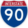 I-90
I-90 -
 US 20
US 20 -
 SR 2
SR 2
Airports and landing strips
- Hustons Airport
Lakes
- Lancaster Lake
- Spicer Lake
History
Olive Township was formed in 1830. It was named for Olive Stanton Vail, whose husband was the first election judge in the township.[3]
School districts
Political districts
- Indiana's 2nd congressional district
- State House District 7
- State Senate District 8
References
- United States Census Bureau 2008 TIGER/Line Shapefiles
- United States Board on Geographic Names (GNIS)
- IndianaMap
- ↑ "Olive Township". Geographic Names Information System. United States Geological Survey. Retrieved 2009-07-07.
- ↑ United States Census Bureau American FactFinder
- ↑ History of New Carlisle, Indiana
External links
 |
Galien Township, Berrien County, Michigan | Bertrand Township, Berrien County, Michigan | | |
| Hudson Township, LaPorte County Wills Township, LaPorte County |
|
Warren Township | ||
| ||||
| | ||||
| Lincoln Township, LaPorte County | Greene Township |
| |||||||||||||||||||||||||||||||||