Oldenzaal
| Oldenzaal | |||
|---|---|---|---|
| Municipality | |||
|
Former city hall of Oldenzaal | |||
| |||
.svg.png) Location in Overijssel | |||
| Coordinates: 52°19′N 6°56′E / 52.317°N 6.933°ECoordinates: 52°19′N 6°56′E / 52.317°N 6.933°E | |||
| Country | Netherlands | ||
| Province | Overijssel | ||
| Government[1] | |||
| • Body | Municipal council | ||
| • Mayor | Theo Schouten (PvdA) | ||
| Area[2] | |||
| • Total | 21.95 km2 (8.47 sq mi) | ||
| • Land | 21.55 km2 (8.32 sq mi) | ||
| • Water | 0.40 km2 (0.15 sq mi) | ||
| Elevation[3] | 48 m (157 ft) | ||
| Population (May 2014)[4] | |||
| • Total | 32,198 | ||
| • Density | 1,494/km2 (3,870/sq mi) | ||
| Demonym | Oldenzaler | ||
| Time zone | CET (UTC+1) | ||
| • Summer (DST) | CEST (UTC+2) | ||
| Postcode | 7570–7579 | ||
| Area code | 0541 | ||
| Website |
www | ||


Oldenzaal (Dutch pronunciation: [ˈɔldə(n)ˌzaːl]) is a municipality and a city in the eastern province of Overijssel in the Netherlands. It is part of the region of Twente and is close to the German border.
It received city rights in 1249. Historically, the city was part of the Hanseatic League as a subsidiary city of the fellow Hanseatic city of Deventer.
Located on the A1 motorway from Amsterdam to Germany, Oldenzaal also has a rail connection to Hengelo.
Transportation
The town is served by the Oldenzaal railway station.
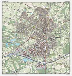
Dutch Topographic map of Oldenzaal (town), as of June 2014

Notable residents
- Derk Boerrigter, football (soccer) player
- Ellen van Langen, middle distance runner
- Frédérique Ankoné, speed skater
- Jan Vennegoor of Hesselink, football (soccer) player
- Mieke Telkamp, singer
- Patrick Gerritsen, football (soccer) player
- Raimond van der Gouw, football (soccer) player
- Rudie Kemna, cyclist
- Ruud Fiselier (Rudy Gunn), DJ/ Producer/ Singer/ Actor
- Nathalie Timmermans, softball player
- Wilfried Brookhuis, football (soccer) player
- Tim Breukers, football (soccer) player
- Henri Max Corwin (Cohen), World War II humanitarian and founder of a propaganda museum
- Björn Kuipers, football (soccer) referee
- Bart and Tim Grönefeld, watchmakers, founders of Grönefeld Exclusive Timepieces
References
- ↑ "Burgemeester Theo Schouten" [Mayor Theo Schouten] (in Dutch). Gemeente Oldenzaal. Retrieved 31 March 2014.
- ↑ "Kerncijfers wijken en buurten" [Key figures for neighbourhoods]. CBS Statline (in Dutch). CBS. 2 July 2013. Retrieved 12 March 2014.
- ↑ "Postcodetool for 7571CD". Actueel Hoogtebestand Nederland (in Dutch). Het Waterschapshuis. Retrieved 31 March 2014.
- ↑ "Bevolkingsontwikkeling; regio per maand" [Population growth; regions per month]. CBS Statline (in Dutch). CBS. 26 June 2014. Retrieved 24 July 2014.
External links
 Media related to Oldenzaal at Wikimedia Commons
- Official website
 |
Dinkelland | | ||
| Dinkelland | |
Losser | ||
| ||||
| | ||||
| Enschede |
| ||||||||||||||||||||||||||||||||||||||||||||||||||||||||
| |||||||||||||
