Old Weston
| Old Weston | |
 Manor Farm |
|
 Old Weston |
|
| Population | 250 United Kingdom Census 2011 |
|---|---|
| OS grid reference | TL101756 |
| – London | 143.87 km (89.40 mi) |
| Civil parish | Old Weston |
| District | Huntingdonshire |
| Shire county | Cambridgeshire |
| Region | East |
| Country | England |
| Sovereign state | United Kingdom |
| Post town | HUNTINGDON |
| Postcode district | PE17 |
| Dialling code | 01480 |
| EU Parliament | East of England |
| UK Parliament | Huntingdonshire |
|
|
Coordinates: 52°22′01″N 0°22′59″W / 52.367°N 0.383°W

Old Weston – in Huntingdonshire (now part of Cambridgeshire), England – is a village near Molesworth west of Huntingdon.[1]
In 1870-1872, John Wilson, who was a writer for the "Imperial Gazetteer of England and Wales:" describes the area as, "a parish, with a scattered village, in the district of Thrapston and county of Huntingdon; 8 miles N of Kimbolton r. station. It has a post-office under St. Neots. Acres, 2,012. Real property, £2,364. Pop., 426. Houses, 93. The property is much sub-divided. The living is a p. curacy, annexed to Brington.[2] The church is ancient but good, and has a tower and spire. There are a Wesleyan chapel and a national school." According the 2011 UK population census, the parish of Old Weston had a population of 250 people.[3]

The Village
Old Weston is a rural Village in Huntingdonshire near the Northamptonshire border, with a former World War II airforce base between the parish and the border. The main residency area, is alongside a stream, which flows through Old Weston.[4]The earliest records for Old Weston were mentioned in the Domesday Book of 1086 where it mentions St Swithins' church. The old settlement of Old Weston, before the fire of 1701 which burnt almost all of the cottages, was located on the northern bank of the river, with evidence suggesting that a few of the cottages extended south of the church, located south west of the stream.[5]
Transportation
The B660 runs through Old Weston, connecting the village to the regional town of Huntingdon, via the A14 which starts from Rugby and ends at Ipswich.[6] This route to the rest of the county allows Old Weston to have a public bus route service provided by the Cambridgeshire County Council which operates within Huntingdon, where it runs Monday to Saturday, with all the buses running through the village being serviced by Whippet Coaches Ltd.[7] In addition to the publicly run bus services organized by the county government, there is also a privately run, community transport service running throughout several parishes in the area. The bus service stops at all the town centres including Peterborough, Huntingdon and Stamford, with the bus service beginning at 0900 and returning at 1330.[8]
Population
During 1850-1891, the population of Old Weston decreased significantly from 432 people to 245.[9] This decrease in Old Weston can partly be explained from the nearby town expansion of the Huntingdon parish, "St. John", where the population increased 1,057 people in 1841 to 1,579 people in 1891.[10][11] From 2001-2011, the population of Old Weston increased from 190 people to 250 people. A possible explanation, for this relatively high population increase, can be partly explained from the 2011 "Cambridgeshire parish population census", where it stated that 11 people living in Old Weston were between the age of 0-4, between the two censuses.[12]
Economy
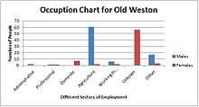
In 1881, Old Weston's main sector of employment was in the agriculture industry, with the majority of the workforce being made up of males, as the landscape was dominantly rural. A vast number of females were also employed, as indicated by the 1881 UK census, however, the census does not delve into the specific areas of employment, despite 56 women working in "Unknown Occupation". With this stated, the largest, specified sector of employment that women were employed in, which has been titled was "Domestic Services" with seven women working within this industry.[13]
Current economy
According to the 2011 Census, a total of 137 Old Weston's residents, aged 16–74, were in some kind of employment. The census breaks down the different types of employment into service and manufacturing industries. The main sector of employment for the majority of residents, was that 30 people (21.9% of the total workforce) were either managers, directors or senior officials. The second largest sector of employment that the Office of National Statistics indicates, is that 29 people (21.2%) worked in professional employment, while the lowest number of people employed in Old Weston was "Elementary Occupation", which includes teachers.[14] While the majority of the residents are employed in the service industry, an increasing number of people are working from home, rather than travel to work, reducing congestion on the roads leading to the two main towns of Huntingdon and Kettering , which is connected to the National Rail.[14]
St Swithins Church
The church located in Old Weston, was named after the Anglo-Saxon bishop, Swithun, whose name means in English "Strong".The church was first recognised in the 1086, Domesday Survey.[15][16] One of the most interesting features about the historic church is within the congregation hall, original paintings from the 13th century depicting a wheel of fortune, and the beheading of St. John the Baptist. St. Margaret, who is depicted as standing on a dragon while under a canopy and St. Catherine. All of the paintings were discovered in 1895, when the church was undergoing major refurbishment during the 19th century.[17]
Village Hall
Old Weston's village hall was built in 1962 after the Beeby family donated the land to the local community, to allow for the creation of a village hall, along with a car park and grassland.[18] Since 1991, the village hall has been used to host Old Weston's annual pantomime, performed by the "The New Old Weston Thespian Society", during March.The performance provides social and charitable functions.[19]
References
- ↑ "Old Weston 1881 Census Data". Vision of Britain. Retrieved 9 February 2015.
- ↑ Wilson, John (1870). Imperial Gazetteer of England and Wales. Edinburgh: A. Fullerton and Co. Retrieved 27 January 2015.
- ↑ "Key Figures for 2011 Census". Neighbourhood Statistics. Office for National Statistics. Retrieved 26 April 2015.
- ↑ "The Parish of Old Weston". British-Towns. Retrieved 17 April 2015.
- ↑ "Old Weston". British History Online. Victoria County History. Retrieved 13 February 2015.
- ↑ "The A14". motorwayservicesonline. Retrieved 16 February 2015.
- ↑ "Bus Timetable". Cambridge County Council. Retrieved 26 April 2015.
- ↑ "Ring and Ride Area 1". HACT. Retrieved 26 April 2015.
- ↑ "Old Weston 1881 Census Data". Vision of Britain. Retrieved 9 February 2015.
- ↑ "Old Weston". A Vision of Britain Through Time. Retrieved 23 March 2015.
- ↑ "Huntingdon, St. John". A Vision of Britain Through Time. Retrieved 23 March 2015.
- ↑ "2011 Population Census: Usual Resident Population by Civil Parish". cambridgeshireinsight.org.uk. Cambridgeshire County Council. Retrieved 20 March 2015.
- ↑ "Occupation data classified into the 24 1881 'Orders', plus sex". Vision of Britain Through Time. Retrieved 12 March 2015.
- ↑ 14.0 14.1 "Old Weston". Neighbourhood Statistics. Office for National Statics. Retrieved 25 March 2015.
- ↑ Argall, Ian. "Old Weston". www.genuki.co.uk. Retrieved 16 March 2015.
- ↑ "Swithin". www.behindthename.com. Retrieved 16 March 2015.
- ↑ "Parishes: Old Weston". www.british-history.ac.uk. Retrieved 23 March 2015.
- ↑ "The Old Weston Village Hall". www.old-weston-past-and-present.com. Retrieved 20 March 2015.
- ↑ "NOWTS". Old Weston Past and Present. Retrieved 19 April 2015.
External links
![]() Media related to Old Weston at Wikimedia Commons
Media related to Old Weston at Wikimedia Commons