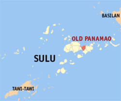
Old Panamao, Sulu
| Old Panamao | |
|---|---|
| Municipality | |
 Map of Sulu with Old Panamao highlighted | |
.svg.png) Old Panamao Location within the Philippines | |
| Coordinates: 05°59′N 121°15′E / 5.983°N 121.250°ECoordinates: 05°59′N 121°15′E / 5.983°N 121.250°E | |
| Country | Philippines |
| Region | Autonomous Region in Muslim Mindanao (ARMM) |
| Province | Sulu |
| District | 2nd district of Sulu |
| Barangays | 31 |
| Government[1] | |
| • Mayor | Gafor Asdurajak |
| Population (2010)[2] | |
| • Total | 37,933 |
| Time zone | PST (UTC+8) |
| ZIP code | 7402 |
| Dialing code | 68 |
| Income class | 4th |
Old Panamao is a fourth class municipality in the province of Sulu, Philippines. According to the 2010 census, it has a population of 37,933 people.[2]
Barangays
Old Panamao is politically subdivided into 31 barangays.[2]
- Asin
- Bakud
- Bangday
- Baunoh
- Bitanag
- Bud Seit
- Bulangsi
- Datag
- Kamalig
- Kan Asaali
- Kan Ukol
- Kan-Dayok
- Kan-Sipat
- Kawasan
- Kulay-kulay
- Lakit
- Lower Patibulan
- Lunggang
- Parang
- Pugad Manaul
- Puhagan
- Seit Higad
- Seit Lake (Pob.)
- Su-uh
- Tabu Manuk
- Tandu-tandu
- Tayungan
- Tinah
- Tubig Gantang
- Tubig Jati
- Upper Patibulan
Demographics
| Population census of Old Panamao | ||
|---|---|---|
| Year | Pop. | ±% p.a. |
| 1990 | 27,189 | — |
| 1995 | 28,549 | +0.92% |
| 2000 | 35,906 | +5.04% |
| 2007 | 49,903 | +4.64% |
| 2010 | 37,933 | −9.50% |
| Source: National Statistics Office[2] | ||
References
- ↑ "Official City/Municipal 2013 Election Results". Intramuros, Manila, Philippines: Commission on Elections (COMELEC). 1 July 2013. Retrieved 5 September 2013.
- ↑ 2.0 2.1 2.2 2.3 "Total Population by Province, City, Municipality and Barangay: as of May 1, 2010". 2010 Census of Population and Housing. National Statistics Office. Retrieved 27 August 2014.
External links
 |
Patikul | Sulu Sea |  | |
| Panglima Estino | |
Luuk | ||
| ||||
| | ||||
| Tutu Bay | |
Kalingalan Caluang |
| ||||||||||