Oichalia, Trikala
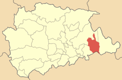
Oichalia Greek: Οιχαλία, before 1981: Νεοχώρι - Neochori[2]) is a town and a former municipality in the Trikala regional unit, Thessaly, Greece. Since the 2011 local government reform it is part of the municipality Farkadona, of which it is a municipal unit.[3] In 2001 the population of the municipality was 5,783, the population of the town proper was 2,936. Oichalia is located 8 km west of Farkadona centre, and 20 km east of the city of Trikala. It is situated on the edge of the Thessalian Plain. The Greek National Road 6 (Larissa - Trikala - Ioannina - Igoumenitsa) passes south pf Oichalia.
Subdivisions
The municipal unit Oichalia is subdivided into the following communities:
- Georganades
- Klokotos
- Krini
- Oichalia
- Petroto
Population
| Year | Settlement population | Municipality population |
|---|
| 1981 | 3,221 | - |
| 1991 | 3,271 | 6,567 |
| 2001 | 2,936 | 5,783 |
See also
External links
References