Ohiya
| Ohiya | |
|---|---|
| Village | |
|
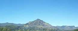
Ohiya, Rahangala Mountain, Pattipola and Hotan plains area (view from Boralanda) | |
| Time zone | Sri Lanka Standard Time Zone (UTC+5:30) |
Ohiya (ඔහිය)is a rural village located in Badulla District of Uva Province, Sri Lanka.[1][2] It is much closer to the Horton Plains National Park.[3] The picturesque Colombo -Badulla Railyway runs through Ohiya.[4] Ohiya is in the Welimada Divisional Secretariat Division and the Grama Niladhari Division number is 62A.[5]
Ohiya is one of the most scenic places in Sri Lanka. On a clear day the view from Dondra Watch at Hill Safari extends up to the southern coast of Sri Lanka.
Population
| Total | Male | Female |
|---|---|---|
| 697 | 332 | 365 |
(Source Welimada Divisional Secretariat 2008-statistics)[6]
Transport
- Ohiya Railway Station (Main line between Colombo and Badulla)[7]
- B508 – Welimada – Ohiya (Bus route via Boralanda)[8][9]
Attractions
- Horton Plains National Park
- Dondra Watch – Hill Safari Eco Lodge Ohiya
- The Ohiya Forest
- Udaveria Estate and surroundings
- The stretch of Railway between Ohiya and Idalgashinna Stations(There are 13 tunnels between these two Railway stations)
- The Devil's Staircase – located beyond Udaweria Estate about 8 km away from the station
- Bamabarakanda Falls (Via Udaweriya Estate)
- The Mountain of Rahangala – located close to Boralanda Town
Sleep
- Ohiya Hill and Safari Lodge
Family Guest House directly next to the railway station in Ohiya. Ohiya Hill and Safari Lodge. The guys will run into you when you get off the train immediately. We paid 1000SLR per night incl. dinner and breakfast package for our trip to Horton Plains National Park. Tuk Tuk charges 2000SLR Return to the entrance of the Horton Plains trailway to Worlds End. You can hike up to the hill but it is 11 km and takes at least 2 hours and approx. more than that. Tuk Tuk is a good chance.
Postal services
- Nearest Post Office – Ohiya Sub Post Office (Postal Code 90168)
Schools
- B/Ohiya Siddharatha Vidyalaya, Ohiya [10]
See also
- Towns in Uva
- History of Uva Province
References
- ↑ Ohiya. Nature.sarisara.com. Retrieved on 2013-03-17.
- ↑ One more heave. dailynews.lk (2009-01-01) . Retrieved on 2013-03-17.
- ↑ The Way to Horton Plains. Nation.lk (2009-03-01). Retrieved on 2013-03-17.
- ↑ Railway Journeys. Island.lk (2009-02-15). Retrieved on 2013-03-17.
- ↑ Territorial Jurisdiction of High Courts, District Courts and Magistrate’s Courts. Ministry of Justice and Law Reforms of Sri Lanka
- ↑ වැලිමඩ ප්රාදේශීය ලේකම් කොට්ඨාශයේ ජනගහනය පිළිබද තොරතුරු 2007– 2008. Welimada Divisional Secretariat. ds.gov.lk
- ↑ 18th Railway Tunnel of Pattipola. Lankanewspapers.com (4 October 2008). Retrieved on 2013-03-17.
- ↑ Central Highlands Nature Tour. Infohub.com. Retrieved on 2013-03-17.
- ↑ Welimada – Boralanda – Ohiya – Horton Plains (32.47 km). Rda.gov.lk. Retrieved on 2013-03-17.
- ↑ Schools. gov.lk (2006) . Retrieved on 2013-03-17.