Ohio State Route 87
| ||||
|---|---|---|---|---|
 | ||||
| Route information | ||||
| Maintained by ODOT | ||||
| Length: | 60.39 mi[1] (97.19 km) | |||
| Existed: | 1924 – present | |||
| Major junctions | ||||
| West end: |
| |||
|
| ||||
| East end: |
| |||
| Location | ||||
| Counties: | Cuyahoga, Geauga, Trumbull | |||
| Highway system | ||||
| ||||

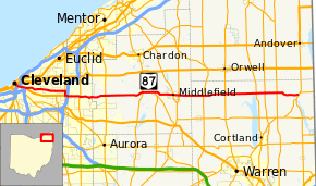
State Route 87 (SR 87) is an east–west highway in northeastern Ohio, a U.S. state. Its western terminus is in Cuyahoga County at US 6, US 42, SR 3 (among other routes) at Public Square in downtown Cleveland and ends at an intersection with SR 5 and SR 7 near Kinsman.
Route description
SR 87 begins at Public Square in Cleveland, at an intersection with US 6 / US 42 / SR 3. It is concurrent with US 422 and SR 8 for just over 2 miles (3.2 km) (as well as SR 14 and SR 43 for a short segment), and then leaves the concurrency to occupy a section of Woodland Avenue. The route heads eastward and becomes Buckeye Road, and then Shaker Boulevard, which is a divided boulevard with RTA commuter rail tracks (the "Rapid") between the east- and westbound lanes as it travels through Shaker Heights.[2]
At Richmond Road in Beachwood, SR 87 joins SR 175 from the north and heads south approximately 1-mile (1.6 km) to Chagrin Boulevard, where the route leaves SR 175 and joins US 422 east. A short distance later, at the I-271 interchange, US 422 leaves the concurrency southward, and SR 87 continues east on Chagrin Boulevard through Woodmere Village and Pepper Pike, and then on Pinetree Road and South Woodland Road, intersects SR 91 (SOM Center Road) and enters Moreland Hills.
SR 87 enters Geauga County and becomes Kinsman Road for most of its remaining length, and intersects SR 306 (Chillicothe Road), passes by Punderson State Park, and intersects SR 44 (Ravenna Road) at Newbury.
The route then enters Burton, where it temporarily becomes Center Street and intersects SR 168 (Cheshire Street); then through Ohio's second largest Amish community in Middlefield as High Street, the route intersects SR 608 (State Street).
Just east of Middlefield, the route resumes its Kinsman Road name, and intersects with SR 528 (Madison Road), before entering Trumbull County.
In Trumbull County, SR 87 intersects SR 534 at Mesopotamia, and then SR 45 at North Bloomfield. Next, it crosses SR 46, followed by its interchange with SR 11. Finally, it intersects SR 193 and reaches its terminus at the SR 5 / SR 7 concurrency north of Kinsman.
History
- Original state route; originally routed from Woodmere to Pennsylvania state line on its current alignment to Burton, State Route 168’s current alignment from Burton to Parkman, and along State Route 88’s current alignment from Parkman to the state line.[3]
- 1926 – Western terminus moved to Cleveland along previously unnumbered roads.[3]
- 1926 – Swapped alignments with State Route 168 east of Burton; old alignment from Parkman to state line was designated State Route 88.[3]
- 1938 – Eastern terminus moved to its current location via previously unnumbered roads.[3]
Major intersections
| County | Location | mi[1] | km | Destinations | Notes |
|---|---|---|---|---|---|
| Cuyahoga | Cleveland | 0.00 | 0.00 | Western terminus of US 322 / US 422 / SR 14 / SR 43; northern terminus of US 42 / SR 3 / SR 8; western end of all concurrencies | |
| 0.06 | 0.10 | Southern terminus of one-block concurrency with US 20 | |||
| 0.58 | 0.93 | Eastern terminus of SR 10 | |||
| 0.65 | 1.05 | Eastbound exit and entrance; exit 171 (I-90) | |||
| 0.70 | 1.13 | Eastbound entrance only | |||
| 0.91 | 1.46 | SR 14 / SR 43 leaves SR 8 / US 422 concurrency with SR 87 | |||
| 1.56 | 2.51 | Exit 162B (I-77) | |||
| 2.42 | 3.89 | Eastern terminus of concurrency with OH 8 / US 422 | |||
| Beachwood | 10.58 | 17.03 | Northern terminus of concurrency with SR 175; Shaker Boulevard continues east without designation | ||
| 11.51 | 18.52 | Southern terminus of concurrency with SR 175; Western terminus of concurrency with US 422 | |||
| 11.86 | 19.09 | Eastern terminus of concurrency with US 422; exit 29 (I-271) | |||
| Pepper Pike | 14.60 | 23.50 | |||
| Geauga | Russell Township | 20.06 | 32.28 | ||
| Newbury Township | 27.88 | 44.87 | |||
| Burton | 30.40 | 48.92 | Northern terminus of SR 168 / SR 700 | ||
| Middlefield | 34.41 | 55.38 | |||
| 35.53 | 57.18 | ||||
| Trumbull | Mesopotamia Township | 40.54 | 65.24 | ||
| Bloomfield Township | 45.09 | 72.57 | |||
| Greene Township | 51.45 | 82.80 | |||
| Greene–Gustavus township line | 53.20 | 85.62 | Exit 68 (SR 11) | ||
| Gustavus Township | 55.68 | 89.61 | |||
| Kinsman Township | 60.39 | 97.19 | Eastern terminus of SR 87 | ||
1.000 mi = 1.609 km; 1.000 km = 0.621 mi
| |||||
References
Route map: Bing
- ↑ 1.0 1.1 "Division of Planning - Office of Technical Services - Destape files". ODOT. July 16, 2013. Retrieved February 15, 2014 — Cuyahoga County, Geauga County, Trumbull County
- ↑ "Great Places in America: Streets". American Planning Association. 2012. Retrieved October 4, 2012.
- ↑ 3.0 3.1 3.2 3.3 John Simpson’s Route 87 page