Ohio State Route 748
| ||||
|---|---|---|---|---|
 | ||||
| Route information | ||||
| Maintained by ODOT | ||||
| Length: | 5.80 mi[1] (9.33 km) | |||
| Existed: | 1937 – present | |||
| Major junctions | ||||
| South end: |
| |||
| North end: |
| |||
| Location | ||||
| Counties: | Butler | |||
| Highway system | ||||
| ||||

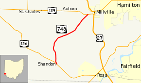
State Route 748 (SR 748) is a north–south state highway in southwestern Ohio, a U.S. state. Situated in west-central Butler County, State Route 748 has its southern terminus at State Route 126 in the unincorporated community of Shandon. Its northern terminus is at State Route 129 near Millville, just 0.5 miles (0.80 km) west of State Route 129's junction with U.S. Route 27.
For its entire length, State Route 748 is also known as Millville-Shandon Road.
Route description
Existing entirely within Butler County, State Route 748 is not included within the National Highway System.[2]
State Route 748 commences at its junction with State Route 126 in the hamlet of Shandon. Starting out in a northwesterly direction, the highway passes through a residential neighborhood. Bending to the north, the highway enters into rural Morgan Township. The majority of State Route 748 passes amidst farmland, with the occasional patch of trees and numerous houses lining the roadway. After traveling due north, the highway bends to the northwest, meets Bell Road, then bends back to the north. State Route 748 next bends to the northeast and then east-northeast, as it crosses Morgan-Ross Road, and into Ross Township. Following intersections with Kirchling Road and Layhigh Road, the state route bends back to the northeast, and crosses Fenton Road. The highway passes a number of houses prior to arriving at its endpoint at a T-intersection with State Route 129 approximately 0.5 miles (0.80 km) of U.S. Route 27 and the village of Millville.[3]
History
Created in 1937 along the routing that it currently occupies between State Route 126 and State Route 129, State Route 748 has not experienced any major changes since its inception.[4][5]
Major intersections
The entire route is in Butler County.
| Location | mi[1] | km | Destinations | Notes | |
|---|---|---|---|---|---|
| Morgan Township | 0.00 | 0.00 | |||
| Ross Township | 5.80 | 9.33 | |||
| 1.000 mi = 1.609 km; 1.000 km = 0.621 mi | |||||
References
Route map: Bing
- ↑ 1.0 1.1 Ohio Department of Transportation. "Technical Services Straight Line Diagrams" (PDF). Retrieved 2013-07-06.
- ↑ National Highway System: Ohio (PDF) (Map). Federal Highway Administration. December 2003. Retrieved 2010-06-23.
- ↑ Yahoo!; Navteq (2010-06-25). "Overview Map of State Route 748" (Map). Yahoo! Maps. Yahoo!. Retrieved 2010-06-25.
- ↑ Ohio State Map (Map). Ohio Department of Transportation. 1936.
- ↑ Ohio State Map (Map). Ohio Department of Transportation. 1937.