Ohio State Route 746
| ||||
|---|---|---|---|---|
 | ||||
| Route information | ||||
| Maintained by ODOT | ||||
| Length: | 13.00 mi[1] (20.92 km) | |||
| Existed: | 1937 – present | |||
| Major junctions | ||||
| South end: |
| |||
| North end: |
| |||
| Location | ||||
| Counties: | Morrow, Marion | |||
| Highway system | ||||
| ||||

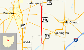
State Route 746 (SR 746, OH 746) is a north–south state highway located in central Ohio, a U.S. state. Its southern terminus is at U.S. Route 42 approximately 3 miles (4.8 km) north of Ashley, and its northern terminus is at State Route 309 in Caledonia.
Route description
The majority of Ohio State Route 746's route lies within rural territory, passing amidst a vastness of farmland. Beginning at the intersection of U.S. Route 42 and Morrow County Road 155 in Westfield Township, Ohio State Route 746 runs westerly for a short distance, crossing County Road 156 before turning north at the County Road 153 intersection. Ohio State Route 746 passes intersections with County Road 25, Helmlich Road, Beatty Road and County Road 148 before entering Marion County, and correspondingly, Richland Township. Running inside of the Marion-Morrow County Line by approximately 0.25 miles (0.40 km), Ohio State Route 746 continues northerly past intersections with Marion County Roads 123 and 154 prior to intersecting Ohio State Route 529. Next, the state highway meets County Road 161, followed by County Road 169, where it enters Claridon Township. North of there, Ohio State Route 746 meets Ohio State Route 95, then crosses Roberts Road and Marion-Williamsport Road before bending to the northwest as it goes over the Olentangy River. Ohio State Route 746 turns north again where it intersects County Road 163, and comes to an end just after it enters Caledonia at its intersection with Ohio State Route 309.[2]
History
In 1937, Ohio State Route 746 was established along its current alignment between U.S. Route 42 and Ohio State Route 309. Other than the fact that when first designated, the highway intersecting Ohio State Route 746 at its northern terminus was U.S. Route 30S instead of Ohio State Route 309, there have been no major changes to Ohio State Route 746.[3][4]
Major intersections
| County | Location | mi[1] | km | Destinations | Notes |
|---|---|---|---|---|---|
| Morrow | Westfield Township | 0.00 | 0.00 | ||
| Marion | Richland Township | 5.49 | 8.84 | ||
| Claridon Township | 9.71 | 15.63 | |||
| Caledonia | 13.00 | 20.92 | |||
| 1.000 mi = 1.609 km; 1.000 km = 0.621 mi | |||||
References
- ↑ 1.0 1.1 Ohio Department of Transportation. "Technical Services Straight Line Diagrams". Retrieved 2010-04-14.
- ↑ Yahoo!; Navteq (2010-04-14). "Overview Map of Ohio State Route 746" (Map). Yahoo! Maps. Yahoo!. Retrieved 2010-04-14.
- ↑ Ohio State Map (Map). Ohio Department of Transportation. 1936.
- ↑ Ohio State Map (Map). Ohio Department of Transportation. 1937.
External links
Route map: Bing