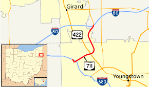
Ohio State Route 711
| ||||
|---|---|---|---|---|
 | ||||
| Route information | ||||
| Maintained by ODOT | ||||
| Length: | 3.35 mi[1] (5.39 km) | |||
| Existed: | 1974 – present | |||
| Major junctions | ||||
| South end: |
| |||
|
| ||||
| North end: |
| |||
| Location | ||||
| Counties: | Mahoning, Trumbull | |||
| Highway system | ||||
| ||||

State Route 711 (SR 711), also known as the "Robert E. Hagan Memorial Highway" between its southern terminus and US 422,[2] is a three-mile (5 km), four-lane, north–south, limited access freeway. It is located in Mahoning and Trumbull counties. Its termini are I-680 to the south and the I-80 / SR 11 interchange to the north. The north-end ramps are directional, only serving travelers to and from the east via Interstate 80 and the north via State Route 11.
History
Local leaders first suggested a highway linking Girard and Youngstown in 1968. Originally the four-lane divided highway ended at US 422 and Burlington Street when it was completed in 1971. Money wasn't made available for the US 422 to I-80 connector until 1999, and construction on the section began in 2002. The project was finished in 2005, opening October 24 of that year,[3] with a total cost of about $60 million.
Exit list
| County | Location | mi[1] | km | Destinations | Notes |
|---|---|---|---|---|---|
| Mahoning | Youngstown | 0.00– 0.38 | 0.00– 0.61 | Exit 3A (I-680) | |
| 0.67 | 1.08 | Stephens Street / Salt Springs Road | Southbound exit / entrance only | ||
| 1.24 | 2.00 | ||||
| Mahoning– Trumbull | Youngstown– Girard | 2.00 | 3.22 | ||
| Trumbull | Liberty Township | 3.16– 3.35 | 5.09– 5.39 | No access to westbound I-80 / southbound SR 11; exit 228A (I-80) | |
| 1.000 mi = 1.609 km; 1.000 km = 0.621 mi | |||||
References
Route map: Bing
- ↑ 1.0 1.1 Ohio Department of Transportation. "Technical Services Straight Line Diagrams".
- ↑ Ohio Revised Code 5533.643
- ↑ Goodwin, John W., Jr. (2005-10-25). "After Years, Residents Can Hit the Open Road". The Vindicator. Retrieved 2013-03-05.
