Ohio State Route 658
| ||||
|---|---|---|---|---|
 | ||||
| Route information | ||||
| Maintained by ODOT | ||||
| Length: | 11.05 mi[1] (17.78 km) | |||
| Existed: | 1937 – present | |||
| Major junctions | ||||
| South end: |
| |||
| North end: |
| |||
| Location | ||||
| Counties: | Guernsey | |||
| Highway system | ||||
| ||||

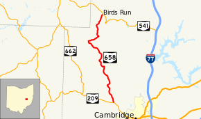
State Route 658 (SR 658) is a 11.05-mile-long (17.78 km) state highway in Guernsey County, Ohio. Located in the northwest quadrant of the county, it connects SR 209 in Adams Township (northwest of Cambridge) with SR 541 in Wheeling Township.
History
SR 658 was designated on a road connecting SR 209 and what was then numbered SR 271 (now SR 541) in 1937.[2][3] Except for its transition from a gravel-paved road to a fully asphalt-paved road by 1957, the road has not experienced any major changes since its designation.
Major intersections
The entire route is in Guernsey County.
| Location | mi[1] | km | Destinations | Notes | |
|---|---|---|---|---|---|
| Adams Township | 0.00 | 0.00 | |||
| Wheeling Township | 11.05 | 17.78 | |||
| 1.000 mi = 1.609 km; 1.000 km = 0.621 mi | |||||
References
Route map: Bing
- ↑ 1.0 1.1 Ohio Department of Transportation. "Technical Services Straight Line Diagrams". Retrieved October 5, 2013.
- ↑ Map of Ohio Showing State Routes (MRSID) (Map). Cartography by ODHPW. Ohio Department of Highways and Public Works. 1936. Retrieved 2013-10-05.
- ↑ Map of Ohio Showing State Routes (MRSID) (Map). Cartography by ODHPW. ODHPW. 1937. Retrieved 2013-10-05.