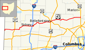
Ohio State Route 47
| ||||
|---|---|---|---|---|
 | ||||
| Route information | ||||
| Maintained by ODOT | ||||
| Length: | 105.23 mi[1] (169.35 km) | |||
| Existed: | 1933 – present | |||
| Major junctions | ||||
| West end: |
| |||
|
| ||||
| East end: |
| |||
| Location | ||||
| Counties: | Darke, Shelby, Logan, Union, Delaware, Marion | |||
| Highway system | ||||
| ||||

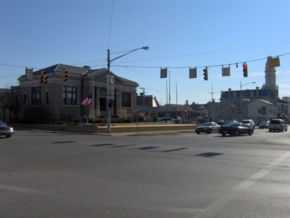
State Route 47 (SR 47) is a state highway running from the Indiana border at Union City to Waldo, about ten miles (16 km) south of Marion. In Bellefontaine, State Route 47 follows the path of different streets (even though neither are one-way) from Main Street and Sandusky Avenue to the intersection just north of Mary Rutan Hospital, about one-half mile north of the Main-Sandusky intersection. The westbound portion of State Route 47 goes down Main, while the eastbound portion goes north on Madriver Street during this stretch. Nobody really knows why the route was designated this way when none of the streets involved are one-way. It was State Route 68 until 1933, when U.S. Route 68 was commissioned. Since both roads run through a common county in Ohio (Logan), and also since there is a rule that there can be no Ohio State Routes with the same number as US highways within Ohio, the number was changed to 47.
Route description
History
Major intersections
| County | Location | mi[1] | km | Destinations | Notes |
|---|---|---|---|---|---|
| Darke | Union City | 0.00 | 0.00 | Indiana state line | |
| Brown Township | 7.64 | 12.30 | |||
| Ansonia | 10.51 | 16.91 | |||
| Richland–York township line | 13.88 | 22.34 | |||
| Versailles | 18.54 | 29.84 | Western end of SR 185 concurrency | ||
| 18.80 | 30.26 | Northern terminus of SR 121; eastern end of SR 185 concurrency | |||
| Shelby | Cynthian Township | 27.73 | 44.63 | ||
| Sidney | 37.78– 37.89 | 60.80– 60.98 | Exit 92 (I-75) | ||
| 39.26 | 63.18 | Western end of SR 29 westbound concurrency | |||
| 39.35 | 63.33 | Eastern end of SR 29 westbound concurrency; western end of SR 29 eastbound concurrency | |||
| 39.52 | 63.60 | Eastern end of SR 29 eastbound concurrency | |||
| Salem Township | 47.37 | 76.23 | Southern terminus of SR 65 | ||
| Logan | Pleasant Township | 56.13 | 90.33 | ||
| Bellefontaine | 64.20 | 103.32 | Western end of US 68 southbound concurrency | ||
| 64.30 | 103.48 | Eastern end of US 68 northbound concurrency; western end of US 68 southbound concurrency; western terminus of SR 540 | |||
| 64.40 | 103.64 | Eastern end of US 68 southbound concurrency; eastern end of SR 540 concurrency | |||
| Bokes Creek Township | 74.22 | 119.45 | |||
| Union | York Township | 83.46 | 134.32 | ||
| 85.69 | 137.90 | ||||
| Richwood | 92.26 | 148.48 | Western end of SR 37 concurrency | ||
| 92.33 | 148.59 | Eastern end of SR 37 concurrency | |||
| Delaware | Thompson Township | 96.07 | 154.61 | Western end of SR 4 concurrency | |
| Marion | Prospect Township | 96.74 | 155.69 | Eastern end of SR 4 concurrency | |
| Prospect Township–Prospect municipal line | 98.21 | 158.05 | Northern terminus of SR 257 | ||
| Prospect | 98.44 | 158.42 | |||
| Waldo Township | 104.46 | 168.11 | Western terminus of SR 229 | ||
| Waldo | 105.23 | 169.35 | Southern termini of SR 98 and SR 423 | ||
1.000 mi = 1.609 km; 1.000 km = 0.621 mi
| |||||
References
External Links
Route map: Bing