Ohio State Route 380
| ||||
|---|---|---|---|---|
 | ||||
| Route information | ||||
| Maintained by ODOT | ||||
| Length: | 18.04 mi[1] (29.03 km) | |||
| Existed: | 1935[2][3] – present | |||
| Major junctions | ||||
| South end: |
| |||
| North end: |
| |||
| Location | ||||
| Counties: | Clinton, Greene | |||
| Highway system | ||||
| ||||

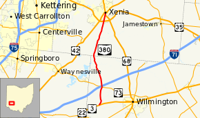
State Route 380 (SR 380) is a north–south state highway in the southwestern quadrant of the U.S. state of Ohio. The southern terminus of SR 380 is at its junction with the concurrency of U.S. Route 22 (US 22) and SR 3 nearly 3 miles (4.8 km) northeast of Clarksville. Its northern terminus is in downtown Xenia, following a brief concurrency with US 68, at the signalized intersection where the U.S. route meets US 42.
Route description
Along its way, SR 380 travels through the northwestern part of Clinton County and the southwestern quadrant of Greene County. No segment of SR 380 is included within the National Highway System (NHS). The NHS is a network of highways deemed most important for the economy, mobility and defense of the country.[4]
History
SR 380 was assigned in 1935. Initially, it served as a spur route that ran along its present alignment from its current northern terminus in downtown Xenia southwest to the former northwestern Clinton County village of New Burlington.[2][3] Three years after is designation, SR 380 was extended to the southeast from New Burlington along a previously un-numbered roadway to its present southern terminus at the US 22/SR 3 concurrency near Clarksville.[5][6]
Major intersections
| County | Location | mi[1] | km | Destinations | Notes |
|---|---|---|---|---|---|
| Clinton | Adams Township | 0.00 | 0.00 | ||
| Chester Township | 3.54 | 5.70 | |||
| Greene | Xenia | 17.67 | 28.44 | Southern end of US 68 concurrency | |
| 18.04 | 29.03 | Northern end of US 68 concurrency | |||
1.000 mi = 1.609 km; 1.000 km = 0.621 mi
| |||||
References
Route map: Bing
- ↑ 1.0 1.1 Ohio Department of Transportation. "Technical Services Straight Line Diagrams". Retrieved 2011-03-13.
- ↑ 2.0 2.1 Map of Ohio Showing State Highway System (MRSID) (Map). Cartography by ODOH. Ohio Department of Highways. 1934. Retrieved 2011-03-16.
- ↑ 3.0 3.1 Official Ohio Highway Map (MRSID) (Map). Cartography by ODOH. Ohio Department of Highways. 1935. Retrieved 2011-03-16.
- ↑ National Highway System: Ohio (PDF) (Map). Federal Highway Administration. December 2003. Retrieved 2011-03-13.
- ↑ Official Ohio Highway Map (MRSID) (Map). Cartography by ODOH. Ohio Department of Highways. 1937. Retrieved 2011-03-16.
- ↑ Official Ohio Highway Map (MRSID) (Map). Cartography by ODOH. Ohio Department of Highways. 1938. Retrieved 2011-03-16.