Ohio State Route 38
| ||||
|---|---|---|---|---|
 | ||||
| Route information | ||||
| Maintained by ODOT | ||||
| Length: | 53.097 mi[1] (85.451 km) | |||
| Existed: | 1924 – present | |||
| Major junctions | ||||
| South end: |
| |||
|
| ||||
| North end: |
| |||
| Location | ||||
| Counties: | Fayette, Madison, Union | |||
| Highway system | ||||
| ||||

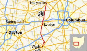
State Route 38 (SR 38) is a south-north state highway in the state of Ohio. Its southern terminus is in Washington Court House at the U.S. Route 62 / SR 3 concurrency and its northern terminus is in Marysville at the intersection of 5th Street and Main Street where the road continues north as SR 31.
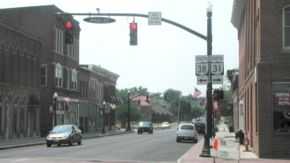
On its winding route through central Ohio, State Route 38 mainly offers views of rolling or flat farmland planted with corn, soybeans, and other crops. It also passes through a variety of towns including Washington Court House, London, and Marysville, the county seats of all three counties through which it travels.
History
When it was designated in 1923 along existing state highways, SR 38 traveled from Ripley on the Ohio River to Marion.[2][3] This route included its current segment between Washington Court House and Marysville, but also served Russellville and Hillsboro. In 1927, the segment of SR 38 north of Marysville was deleted and renumbered by a relocated SR 4.[4][5] The route would reach its current route in 1932 when US 62 was brought into Ohio replacing SR 38 between Ripley and Washington Court House.[6][7] Since then, the routing of SR 38 has not undergone any major changes.[8]
Major junctions
| County | Location | mi[1] | km | Destinations | Notes |
|---|---|---|---|---|---|
| Fayette | Washington Court House | 0.00 | 0.00 | ||
| Bloomingburg | 5.47 | 8.80 | Northern terminus of SR 238 | ||
| Paint Township | 9.11 | 14.66 | Eastern terminus of SR 734 | ||
| 12.66 | 20.37 | Exit 75 (I-71) | |||
| Madison | Midway | 15.52 | 24.98 | ||
| London | 26.53 | 42.70 | Southern end of SR 56 / SR 665 concurrency | ||
| 26.84 | 43.19 | Southern end of US 42 / SR 142 concurrency; northern end of SR 56 / SR 665 concurrency | |||
| 27.04 | 43.52 | Northern end of SR 142 concurrency | |||
| 27.26 | 43.87 | Northern end of US 42 concurrency | |||
| Deer Creek Township | 30.41 | 48.94 | |||
| Deer Creek–Monroe township line | 34.94 | 56.23 | |||
| Union | Union Township | 43.42 | 69.88 | Southern end of SR 161 concurrency | |
| Darby Township | 43.61 | 70.18 | Northern end of SR 161 concurrency | ||
| Marysville | 51.43 | 82.77 | Northern terminus of SR 736 | ||
| 53.10 | 85.46 | Southern terminus of SR 31 | |||
1.000 mi = 1.609 km; 1.000 km = 0.621 mi
| |||||
References
Route map: Bing
- ↑ 1.0 1.1 Ohio Department of Transportation. "Roadway Description Inventory Report - DESTAPE".
- ↑ Map of Ohio State Highways Showing All Improved Roadways (MRSID) (Map). Cartography by E.C. Blosser. Ohio Department of Highways and Public Works. 1922. Retrieved August 18, 2013.
- ↑ Map of Ohio Showing State Routes (MRSID) (Map). Cartography by L.A. Boulay, Director. ODOH. 1923. Retrieved August 18, 2013.
- ↑ Map of Ohio Showing State Routes (MRSID) (Map). Cartography by G.F. Schlesinger, Director. ODOH. 1926. Retrieved September 22, 2013.
- ↑ Map of Ohio Showing State Routes (MRSID) (Map). Cartography by G.F. Schlesinger, Director. ODOH. 1927. Retrieved September 22, 2013.
- ↑ Map of Ohio Showing State Highway System (MRSID) (Map). Cartography by O.W. Merrell, Director. ODOH. 1931. Retrieved August 19, 2013.
- ↑ Map of Ohio Showing State Highway System (MRSID) (Map). Cartography by O.W. Merrell, Director. ODOH. 1932. Retrieved August 19, 2013.
- ↑ 2007-2009 Official Ohio Transportation Map (MRSID) (Map). Cartography by James G. Beasley, Director. Ohio Department of Transportation. 2007. Retrieved August 20, 2013.