Ohio State Route 349
| ||||
|---|---|---|---|---|
 | ||||
| Route information | ||||
| Maintained by ODOT | ||||
| Length: | 2.37 mi[1] (3.81 km) | |||
| Existed: | 1934 – present | |||
| Major junctions | ||||
| South end: |
| |||
| North end: |
| |||
| Location | ||||
| Counties: | Jackson, Vinton | |||
| Highway system | ||||
| ||||

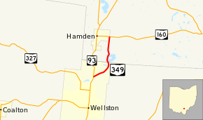
State Route 349 (SR 349) is a north–south state highway in south-central Ohio. State Route 349 has its southern terminus is at State Route 93 in Wellston. Its northern terminus is at State Route 160 in Hamden. Besides providing a shortcut between State Route 93 and State Route 160 around Hamden, State Route 349 allows access to Lake Alma State Park in Vinton County.
Route description
State Route 349's starting point is a T-intersection with State Route 93 is the northern portion of Wellston. Heading northeast from this intersection, State Route 349 is bounded by woods on the south side, while closely being paralleled by the Wellston Bike Path, and passes by a commercial business and a residence on the north side, before forest also fills on that side of the roadway. State Route 349 passes intersections with two side streets on the south side of the highway (Mitchell Drive and Amber Drive), and then reaches its intersection with Wellston Park Road. Bending to the north, the state highway departs Wellston as it crosses the boundary from Jackson County into Vinton County. The Wellston Bike Path comes to an end at this point, as well.
Upon crossing the county line, not only does State Route 349 enter Clinton Township, but it also enters Lake Alma State Park. At the county line, State Route 349 intersects a road that follows the east side of Lake Alma. Heading north from that point, the state highway straddles the western side of the lake. Off the east shoulder of the State Route 349 is a pedestrian bridge that links the highway with a small, forested island that is located in the western end of Lake Alma. The road that follows the east side of the lake loops back around to meet the state route just north of the lake, at a point where the highway passes the main entrance into Lake Alma State Park. State Route 349 then bends to the northwest briefly, prior to turning to the north-northeast, bounded by heavy woods on both sides of the road. After meeting the village limits of Hamden, State Route 349 straddles the eastern boundary of the village, up to the point where it arrives at its endpoint at its junction with State Route 160.[2]
State Route 349 is not included as a part of the National Highway System.[3]
History
State Route 349 was first designated in 1934 along the routing that it currently occupies. When it made its debut, the highway intersecting State Route 349 at its southern terminus was State Route 75 instead of State Route 93. Other than that, State Route 349 has not seen any major changes since its inception.[4][5]
Major intersections
| County | Location | mi[1] | km | Destinations | Notes |
|---|---|---|---|---|---|
| Jackson | Wellston | 0.00 | 0.00 | ||
| Vinton | Hamden | 2.37 | 3.81 | ||
| 1.000 mi = 1.609 km; 1.000 km = 0.621 mi | |||||
References
Route map: Bing
- ↑ 1.0 1.1 Ohio Department of Transportation. "Technical Services Straight Line Diagrams". Retrieved 2010-05-18.
- ↑ Yahoo!; Navteq (2010-05-19). "Overview Map of State Route 349" (Map). Yahoo! Maps. Yahoo!. Retrieved 2010-05-19.
- ↑ National Highway System: Ohio (PDF) (Map). Federal Highway Administration. December 2003. Retrieved 2010-05-19.
- ↑ Ohio State Map (Map). Ohio Department of Transportation. 1933.
- ↑ Ohio State Map (Map). Ohio Department of Transportation. 1934.