Ohio State Route 327
| ||||
|---|---|---|---|---|
 | ||||
| Route information | ||||
| Maintained by ODOT | ||||
| Length: | 47.35 mi[1] (76.20 km) | |||
| Existed: | 1933 – present | |||
| Major junctions | ||||
| South end: |
| |||
| North end: |
| |||
| Location | ||||
| Counties: | Jackson, Vinton, Ross, Hocking | |||
| Highway system | ||||
| ||||

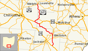
State Route 327 (SR 327) is a north–south state highway in the south central portion of the U.S. state of Ohio. Its southern terminus is at U.S. Route 35 about 7 miles (11 km) southeast of Jackson, at a split-grade intersection. Heading north, the road crosses paths with SR 32 and SR 124 at an interchange which completed in 2004 south of Wellston. Leaving Wellston, the road is less traveled as it passes by forests and open land. These characteristics continue until its northern terminus at SR 180 in Adelphi.
History
SR 327 was commissioned in 1932, routed between Roads and Wellston.[2][3] In 1935 the highway was extended north to Adelphi.[4][5] The highway was extended south to U.S. Route 35 in 1937.[6][7]
Major intersections
| County | Location | mi[1] | km | Destinations | Notes | |||
|---|---|---|---|---|---|---|---|---|
| Jackson | Bloomfield Township | 0.00 | 0.00 | |||||
| Milton Township | 6.76 | 10.88 | Southern end of SR 124 concurrency | |||||
| 7.22 | 11.62 | Northern end of SR 124 concurrency | ||||||
| Wellston | 8.93 | 14.37 | Southern end of SR 93 concurrency | |||||
| 9.79 | 15.76 | Northern end of SR 93 concurrency | ||||||
| Vinton | Harrison Township | 26.18 | 42.13 | Eastern end of US 50 concurrency | ||||
| Ross | Liberty Township | 30.21 | 48.62 | Western end of US 50 concurrency | ||||
| Vinton | Eagle Township | 33.29 | 53.58 | Western terminus of SR 671 | ||||
| Hocking |
No major junctions | |||||||
| Ross |
No major junctions | |||||||
| Hocking |
No major junctions | |||||||
| Ross | Adelphi | 47.35 | 76.20 | |||||
1.000 mi = 1.609 km; 1.000 km = 0.621 mi
| ||||||||
References
Route map: Bing
- ↑ 1.0 1.1 Ohio Department of Transportation. "Technical Services Straight Line Diagrams". Retrieved April 30, 2010.
- ↑ Ohio Department of Highways (1931). Map of Ohio Showing State Routes (MRSID) (Map) (1931 ed.). 1 in=12 mi. Columbus: Ohio Department of Highways. Retrieved October 29, 2013.
- ↑ Ohio Department of Highways (1932). Map of Ohio Showing State Routes (MRSID) (Map) (1932 ed.). 1 in=12 mi. Columbus: Ohio Department of Highways. Retrieved October 29, 2013.
- ↑ Ohio Department of Highways (1934). Map of Ohio Showing State Routes (MRSID) (Map) (1934 ed.). 1 in=12 mi. Columbus: Ohio Department of Highways. Retrieved October 29, 2013.
- ↑ Ohio Department of Highways (1935). Official Highway Map of Ohio (MRSID) (Map) (1935 ed.). Columbus: Ohio Department of Highways. Retrieved October 29, 2013.
- ↑ Ohio Department of Highways (1936). Official Highway Map of Ohio (MRSID) (Map) (1936 ed.). 1 in=12 mi. Columbus: Ohio Department of Highways. Retrieved October 29, 2013.
- ↑ Ohio Department of Highways (1937). Official Highway Map of Ohio (MRSID) (Map) (1937 ed.). 1 in=10 mi. Columbus: Ohio Department of Highways. Retrieved October 29, 2013.