Ohio State Route 308
| ||||
|---|---|---|---|---|
 | ||||
| Route information | ||||
| Maintained by ODOT | ||||
| Length: | 3.00 mi[1] (4.83 km) | |||
| Major junctions | ||||
| South end: |
| |||
| North end: |
| |||
| Location | ||||
| Counties: | Knox | |||
| Highway system | ||||
| ||||

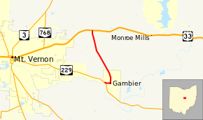
State Route 308 (SR 308, OH 308) is a north–south state highway in the central portion of Ohio, a U.S. state. The southern terminus of State Route 308 is at State Route 229 in the western end of the village of Gambier, and its northern terminus is 3 miles (4.8 km) to the north of that point at a T-intersection with U.S. Route 36 that is located approximately 1.5 miles (2.4 km) east of the city limits of Mount Vernon.
State Route 308 runs exclusively in the central portion of Knox County. The route is not a part of the National Highway System, a system of highways deemed most important for the economy, mobility and defense of the nation.[2]
History
When first designated in 1932, State Route 308 was a spur route connecting U.S. Route 36 with the village of Gambier and Kenyon College.[3][4] It would be 1939 before State Route 308 would become a connector route, when State Route 229 was extended east of Mount Vernon, and in the process connected with State Route 308 at its southern terminus.[5][6]
Major intersections
The entire route is in Knox County.
| Location | mi[1] | km | Destinations | Notes | |
|---|---|---|---|---|---|
| Gambier | 0.00 | 0.00 | |||
| Monroe Township | 3.00 | 4.83 | |||
| 1.000 mi = 1.609 km; 1.000 km = 0.621 mi | |||||
References
Route map: Bing
- ↑ 1.0 1.1 Ohio Department of Transportation. "Technical Services Straight Line Diagrams" (PDF). Retrieved 2013-07-07.
- ↑ National Highway System: Ohio (PDF) (Map). Federal Highway Administration. December 2003. Retrieved 2010-09-19.
- ↑ Ohio State Map (Map). Ohio Department of Transportation. 1931.
- ↑ Ohio State Map (Map). Ohio Department of Transportation. 1932.
- ↑ Ohio State Map (Map). Ohio Department of Transportation. 1938.
- ↑ Ohio State Map (Map). Ohio Department of Transportation. 1939.