Ohio State Route 255
| ||||
|---|---|---|---|---|
 | ||||
| Route information | ||||
| Maintained by ODOT | ||||
| Length: | 18.08 mi[1] (29.10 km) | |||
| Existed: | 1935 – present | |||
| Major junctions | ||||
| West end: |
| |||
| East end: |
| |||
| Location | ||||
| Counties: | Monroe | |||
| Highway system | ||||
| ||||

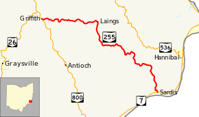
State Route 255 (SR 255) is an east–west state route located in southeast Ohio. Nestled entirely inside the southeast quadrant of Monroe County, the western terminus of State Route 255 is at a T-intersection with State Route 800 approximately 3 miles (4.8 km) south of Woodsfield. Its eastern terminus is at State Route 7 in the hamlet of Sardis, which is situated along the banks of the Ohio River.
History
SR 255 was commissioned in 1935 on the same alignment as it currently occupies.[2][3] Paving of the route between SR 800 and the Little Muskingum River was completed between 1957 and 1959.<ref name="ODOT_1957>Ohio Department of Highways (1957). Official Highway Map of Ohio (MRSID) (Map) (1957 ed.). 1 in=10 mi. Columbus: Ohio Department of Highways. Retrieved September 23, 2013.</ref>[4] The rest of the route was paved by 1961.[4][5]
Major intersections
The entire route is in Monroe County.
| Location | mi[1] | km | Destinations | Notes | |
|---|---|---|---|---|---|
| Center Township | 0.00 | 0.00 | |||
| Lee Township | 18.08 | 29.10 | |||
| 1.000 mi = 1.609 km; 1.000 km = 0.621 mi | |||||
References
Route map: Bing
- ↑ 1.0 1.1 Ohio Department of Transportation. "Technical Services Straight Line Diagrams" (PDF). Retrieved October 17, 2013.
- ↑ Ohio Department of Highways (1934). Map of Ohio Showing State Routes (MRSID) (Map) (1934 ed.). 1 in=12 mi. Columbus: Ohio Department of Highways. Retrieved September 23, 2013.
- ↑ Ohio Department of Highways (1935). Official Highway Map of Ohio (MRSID) (Map) (1935 ed.). Columbus: Ohio Department of Highways. Retrieved September 23, 2013.
- ↑ 4.0 4.1 Ohio Department of Highways (1959). Official Highway Map of Ohio (MRSID) (Map) (1959–1960 ed.). 1 in=10 mi. Columbus: Ohio Department of Highways. Retrieved September 23, 2013.
- ↑ Ohio Department of Highways (1961). Official Highway Map of Ohio (MRSID) (Map) (1961 ed.). 1 in=10 mi. Columbus: Ohio Department of Highways. Retrieved September 23, 2013.