Ohio State Route 239
| ||||
|---|---|---|---|---|
 | ||||
| Route information | ||||
| Maintained by ODOT | ||||
| Length: | 1.22 mi[1] (1.96 km) | |||
| Existed: | 1924 – present | |||
| Major junctions | ||||
| South end: |
| |||
| North end: |
| |||
| Location | ||||
| Counties: | Scioto | |||
| Highway system | ||||
| ||||

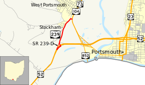
State Route 239 (SR 239) is a short north–south state highway in the southern part of the U.S. state of Ohio. The southern terminus of State Route 239 is at U.S. Route 52, and its northern terminus is at the State Route 73/State Route 104 concurrency. Both endpoints are situated near West Portsmouth.
Created in the mid-1920s, State Route 239 mainly provides access from the southbound direction of the State Route 73/State Route 104 concurrency to westbound U.S. Route 52, and vice versa. The highway is also prone to flooding during heavy rains, which are created by the backups of Scioto River water flowing into Ohio River.
Route description
All of State Route 239 exists within Washington Township in southern Scioto County. The state highway is not included as a part of the National Highway System.[2]
State Route 239 begins at a diamond interchange with U.S. Route 52, with the highway forming a T-intersection with the ramp from and to eastbound U.S. Route 52. The highway heads in a north-northeasterly direction away from the interchange, traversing through a primarily residential area. In doing so, it intersects a series of side streets, and is bounded by scattered patches of woods along the way. State Route 239 arcs to the northeast, passes its intersection with County Road 126 (Slab Run Road), and enters into a commercial district. Two blocks after County Road 126, State Route 239 meets Galena Pike, makes a 90-degree turn to the east-southeast, and one block later, comes to an end when it arrives at a T-intersection with the State Route 73/State Route 104 concurrency just south of the unincorporated community of West Portsmouth.[3]
History
When it was first designated in 1924, State Route 239 was routed along the same path within Scioto County's Washington Township that it maintains to this day. The highway has not experienced any significant changes since its debut.[4][5]
Major intersections
The entire route is in Washington Township, Scioto County.
| mi[1] | km | Destinations | Notes | ||
|---|---|---|---|---|---|
| 0.00 | 0.00 | Interchange | |||
| 0.29 | 0.47 | Northern terminus of SR 239-D | |||
| 1.22 | 1.96 | ||||
| 1.000 mi = 1.609 km; 1.000 km = 0.621 mi | |||||
State Route 239-D
State Route 239-D (SR 239-D) is the designation that ODOT has applied to the 0.28-mile-long (0.45 km) one-way ramp that connects southbound SR 239 with westbound U.S. Route 52 at the southern end of the state route.[6]
References
Route map: Bing
- ↑ 1.0 1.1 Ohio Department of Transportation. "Technical Services Straight Line Diagrams" (PDF). Retrieved 2013-07-08.
- ↑ National Highway System: Ohio (PDF) (Map). Federal Highway Administration. December 2003. Retrieved 2010-09-17.
- ↑ Yahoo!; Navteq (2010-09-17). "Overview Map of State Route 239" (Map). Yahoo! Maps. Yahoo!. Retrieved 2010-09-17.
- ↑ Ohio State Map (Map). Ohio Department of Transportation. 1923.
- ↑ Ohio State Map (Map). Ohio Department of Transportation. 1924.
- ↑ Ohio Department of Transportation. "Technical Services Straight Line Diagrams" (PDF). Retrieved November 10, 2013.