Ohio State Route 201
| ||||
|---|---|---|---|---|
 | ||||
| Route information | ||||
| Maintained by ODOT | ||||
| Length: | 22.72 mi[1] (36.56 km) | |||
| Existed: | 1923[2][3] – present | |||
| Major junctions | ||||
| South end: |
| |||
|
| ||||
| North end: |
| |||
| Location | ||||
| Counties: | Miami, Montgomery | |||
| Highway system | ||||
| ||||

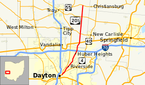
State Route 201 (SR 201) is a 22.72-mile (36.56 km) long north–south state highway in the western portion of the U.S. state of Ohio. The southern terminus of SR 201 is at an interchange with the SR 4 freeway in Dayton. Its northern terminus is at a T-intersection with SR 55 approximately 3.25 miles (5.23 km) east of Casstown.
Route description
Along its path, SR 201 passes through the eastern portion of Montgomery County and the eastern portion of Miami County. There are segments of SR 201 that are included as a part of the National Highway System (NHS). The NHS is a network of highways that are identified as being most important for the economy, mobility and defense of the nation.[4][5]
SR 201 begins in downtown Dayton, just a block from where SR 202 begins. The route starts as Valley Street in Dayton, running northward along the Mad River. SR 201 follows Valley Street until the intersection with Brandt Street, and then follows Brandt Street northward toward Riverside. After entering Riverside, Brandt Street changes its name to Brandt Pike.[6] SR 201 continues as Brandt Pike (even as it again passes inside Dayton city limits) through Huber Heights until it reaches the unincorporated community of Brandt in Bethel Township, Miami County. From there it loses its alternative name and continues northward, ending near Casstown, at the intersection with SR 55.
History
The SR 201 designation was applied in 1923. It was originally routed from its southern terminus in Dayton to its junction with US 40 in Brandt.[7][8] SR 201 was extended to the north in 1937, routed from US 40 in Brandt to SR 55.[9][10]
Major intersections
| County | Location | mi[1][11] | km | Destinations | Notes |
|---|---|---|---|---|---|
| Montgomery | Dayton | 0.00 | 0.00 | Southern terminus at interchange | |
| Huber Heights | 9.13– 9.20 | 14.69– 14.81 | Exit 38 off of I-70, a diamond interchange | ||
| Miami | Bethel Township | 11.78 | 18.96 | Signalized intersection | |
| 14.36 | 23.11 | ||||
| Lostcreek Township | 19.37 | 31.17 | |||
| 22.72 | 36.56 | Northern terminus at T-intersection | |||
| 1.000 mi = 1.609 km; 1.000 km = 0.621 mi | |||||
References
Route map: Bing
- ↑ 1.0 1.1 "Division of Planning - Office of Technical Services - Destape files". ODOT. July 16, 2013. Retrieved November 29, 2013 — Montgomery County, Miami County
- ↑ http://www.dot.state.oh.us/Divisions/TransSysDev/Innovation/prod_services/Documents/StateMaps/otm1922a.sid
- ↑ http://www.dot.state.oh.us/Divisions/TransSysDev/Innovation/prod_services/Documents/StateMaps/otm1923a.sid
- ↑ National Highway System: Ohio (PDF) (Map). Federal Highway Administration. December 2003. Retrieved 2011-05-02.
- ↑ National Highway System (United States)
- ↑ "Zoning Code & Map" (PDF). Zone 12. City of Dayton. January 11, 2011. Retrieved May 4, 2012.
- ↑ Map of Ohio State Highways (MRSID) (Map). Cartography by ODHPW. Ohio Department of Highways and Public Works. April 1922. Retrieved 2011-05-04.
- ↑ Map of Ohio Showing State Routes (MRSID) (Map). Cartography by ODHPW. Ohio Department of Highways and Public Works. July 1923. Retrieved 2011-05-04.
- ↑ Official Ohio Highway Map (MRSID) (Map). Cartography by ODOH. Ohio Department of Highways. 1936. Retrieved 2011-05-04.
- ↑ Official Ohio Highway Map (MRSID) (Map). Cartography by ODOH. Ohio Department of Highways. 1937. Retrieved 2011-05-04.
- ↑ Ohio Department of Transportation. "Technical Services Straight Line Diagrams". Retrieved May 4, 2012.