Ohio State Route 138
| ||||
|---|---|---|---|---|
 | ||||
| Route information | ||||
| Maintained by ODOT | ||||
| Length: | 60.37 mi[1] (97.16 km) | |||
| Existed: | 1923 – present | |||
| Major junctions | ||||
| South end: |
| |||
| North end: |
| |||
| Location | ||||
| Counties: | Highland, Ross, Pickaway | |||
| Highway system | ||||
| ||||
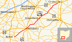
State Route 138 (SR 138) is an east–west state highway in the southwestern portion of the U.S. state of Ohio. Its west terminus is at its intersection with SR 134 in Buford and its eastern terminus is at its intersection with US 22 east of Williamsport.[2]
History
SR 138 was first designated on its current route between Hillsboro and Greenfield in 1923, though the road had been a part of the state highway system since its creation in 1912 as SR 260.[3][4][5] The route was extended in 1937 from its two ends to the route it travels today.[6][7] No major changes to SR 138's routing have occurred since then.
Major junctions
| County | Location | mi[1] | km | Destinations | Notes |
|---|---|---|---|---|---|
| Highland | Clay Township | 0.00 | 0.00 | ||
| Hamer Township | 7.03 | 11.31 | Eastern terminus of SR 131 | ||
| Hillsboro | 15.35 | 24.70 | Western end of US 62 / SR 73 concurrency | ||
| 15.54 | 25.01 | Eastern end of SR 73 concurrency | |||
| 16.30 | 26.23 | Eastern end of US 62 concurrency | |||
| Paint Township | 25.18 | 40.52 | Southern terminus of SR 771 | ||
| Greenfield | 32.48 | 52.27 | Western end of SR 753 concurrency | ||
| 32.79 | 52.77 | Western end of SR 28 concurrency | |||
| 33.23 | 53.48 | Western end of SR 753 concurrency / eastern end of SR 41 concurrency | |||
| Ross | Buckskin Township | 33.81 | 54.41 | Eastern end of SR 28 / SR 41 concurrency | |
| Concord Township | 45.40 | 73.06 | Interchange | ||
| Clarksburg | 50.68 | 81.56 | |||
| Pickaway | Wayne Township | 60.37 | 97.16 | ||
1.000 mi = 1.609 km; 1.000 km = 0.621 mi
| |||||
References
Route map: Bing
- ↑ 1.0 1.1 Ohio Department of Transportation. "Technical Services Straight Line Diagrams". Retrieved April 30, 2010.
- ↑ Google (February 21, 2014). "Ohio State Route 138" (Map). Google Maps. Google. Retrieved February 21, 2014.
- ↑ Map of Ohio Showing State Routes (MRSID) (Map). Cartography by L.A. Boulay, Director. Ohio Division of Highways. 1923. Retrieved August 18, 2013.
- ↑ Map of Ohio Showing Inter-County Highways (MRSID) (Map). Cartography by James R. Marker, State Highway Commissioner. Ohio State Highway Department. 1912. Retrieved August 18, 2013.
- ↑ Map of Ohio State Highways Showing All Improved Roadways (MRSID) (Map). Cartography by E.C. Blosser. ODOH. 1922. Retrieved August 18, 2013.
- ↑ 1936 Official Highway Map (MRSID) (Map). Cartography by John Jaster, Jr., Director. ODOH. 1936. Retrieved August 19, 2013.
- ↑ Official Ohio Highway Map 1937 (MRSID) (Map). Cartography by John Jaster, Jr., Director. ODOH. 1937. Retrieved August 19, 2013.
