Ohio State Route 129
| ||||
|---|---|---|---|---|
 | ||||
| Route information | ||||
| Maintained by ODOT | ||||
| Length: | 25.86 mi[1] (41.62 km) | |||
| Existed: | 1926 – present | |||
| Major junctions | ||||
| West end: |
| |||
|
| ||||
| East end: |
| |||
| Location | ||||
| Counties: | Butler | |||
| Highway system | ||||
| ||||

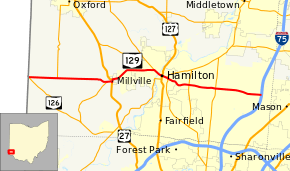
State Route 129 (SR 129) is an east–west highway in southwest Ohio running from its western terminus at SR 126, just east of the Indiana/Ohio state line near Scipio, Ohio. Its eastern terminus is at I-75 in Liberty Township. The route's eastern terminus was historically at State Route 747 until 1999 when the route was moved south ½ mile to the newly built Butler County Veterans Highway.
Butler County Veterans Highway
Butler County Veterans Highway is signed as State Route 129 and is a limited access highway from Hamilton to its terminus at Interstate 75. The highway was conceived in the early 1970s as a link to Interstate 75 from Hamilton. At the time, Hamilton was the second largest city in the US without a direct connection to an Interstate.[2] The highway has had three names. The original name was the Butler County Regional Highway. Shortly after the highway was built, the highway was renamed the Michael A. Fox Highway in honor of an incumbent Butler County Commissioner and former state legislator. In 2004 the highway was renamed to the Butler County Veterans Highway.[3]
Major intersections
The entire route is in Butler County.
| Location | mi[1] | km | Exit | Destinations | Notes | |
|---|---|---|---|---|---|---|
| 0.00 | 0.00 | Western terminus of SR 129 | ||||
| Morgan Township | 3.02 | 4.86 | Southern terminus of SR 732 | |||
| Millville | 8.24 | 13.26 | Northern terminus of SR 748 | |||
| 8.76 | 14.10 | Southern end of US 27 concurrency | ||||
| 9.05 | 14.56 | Northern end of US 27 concurrency | ||||
| Hamilton | 13.71 | 22.06 | Western end of SR 177 concurrency | |||
| 14.71 | 23.67 | Western end of SR 128 concurrency | ||||
| 15.30 | 24.62 | Eastern end of SR 128 and SR 177 concurrency | ||||
| Fairfield Township | 17.83 | 28.69 | 18 | interchange | ||
| Liberty Township | 20.62 | 33.18 | 21 | interchange | ||
| Liberty Township | 24.56 | 39.53 | 24 | Cincinnati–Dayton Road | interchange | |
| 25.44– 25.86 | 40.94– 41.62 | 25 | Eastern terminus of SR 129 | |||
1.000 mi = 1.609 km; 1.000 km = 0.621 mi
| ||||||
References
- ↑ 1.0 1.1 Ohio Department of Transportation. "Technical Services Straight Line Diagrams" (PDF). Retrieved July 7, 2013.
- ↑ Cincinnati Transit Net
- ↑ Cincinnati Enquirer June 2, 2004
External links
Route map: Bing