Ohio State Route 126
| ||||
|---|---|---|---|---|
 | ||||
| Route information | ||||
| Maintained by ODOT | ||||
| Length: | 41.23 mi[1][2] (66.35 km) | |||
| Existed: | 1926 – present | |||
| Major junctions | ||||
| West end: |
| |||
|
| ||||
| East end: |
| |||
| Location | ||||
| Counties: | Butler, Hamilton, Clermont | |||
| Highway system | ||||
| ||||

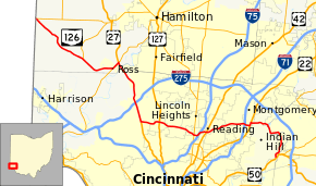
State Route 126 (SR 126) is a state route starting at the Ohio-Indiana border, at a split with State Route 129 near Scipio, Ohio, and ending east of Cincinnati at an intersection with U.S. Route 50 in Milford.
State Route 126 is locally known for comprising most of Ronald Reagan Cross County Highway, a freeway that splits off south Interstate 275 west of Cincinnati, crosses Interstate 75, and ends shortly after an intersection with Interstate 71. The westernmost portion of the highway is designated, but not signed, as Hamilton County Route 453. Ronald Reagan Highway was originally planned to extend eastward to Milford, but local opposition to the project in Indian Hill forced planners to abandon the segment east of Montgomery. Instead, it continues past Interstate 71 as a short divided highway until it merges with Montgomery Road (U.S. Route 22/State Route 3) near the Montgomery Heritage District.
Major junctions
| County | Location | mi[2] | km | Destinations | Notes | |||
|---|---|---|---|---|---|---|---|---|
| Butler | Reily–Morgan township line | 0.00 | 0.00 | Indiana state line | ||||
| 0.02 | 0.03 | Western terminus of SR 129 | ||||||
| Morgan Township | 7.66 | 12.33 | Southern terminus of SR 748 | |||||
| Ross Township | 11.46 | 18.44 | Western end of SR 128 concurrency | |||||
| 12.54 | 20.18 | Interchange; eastern end of SR 128 concurrency; western end of US 27 concurrency | ||||||
| West end of expressway | ||||||||
| Hamilton | Colerain Township | 13.27 | 21.36 | East Miami River Road – Fairfield | Grade-separated single-loop intersection | |||
| 14.82 | 23.85 | Kemper Road | Interchange | |||||
| East end of expressway | ||||||||
| 17.56 | 28.26 | Exit 33 (I-275) | ||||||
| 19.75– 19.92 | 31.78– 32.06 | Interchange; eastern end of US 27 concurrency | ||||||
| West end of freeway | ||||||||
| Mount Healthy– North College Hill city line | 22.13 | 35.61 | ||||||
| Springfield Township | 23.90 | 38.46 | Winton Road | Westbound exit / eastbound entrance only | ||||
| 24.58 | 39.56 | Galbraith Road / Winton Road | ||||||
| Cincinnati | 26.68– 27.06 | 42.94– 43.55 | Exit 10A (I-75); no access from I-75 southbound, from westbound SR 126 to I-75 northbound | |||||
| Reading | 28.10 | 45.22 | Eastbound exit / westbound entrance only | |||||
| 28.52 | 45.90 | Galbraith Road to | Westbound exit / eastbound entrance only | |||||
| Amberley | 29.39 | 47.30 | Ridge Road | |||||
| Blue Ash | 31.27 | 50.32 | Plainfield Road / Hunt Road | |||||
| 31.91– 32.15 | 51.35– 51.74 | Blue Ash Road / Kenwood Road | ||||||
| Montgomery– Sycamore Township line | East end of freeway | |||||||
| 32.73 | 52.67 | Exit 14 (I-71) | ||||||
| Montgomery | 33.34 | 53.66 | Interchange; western end of US 22 / SR 3 concurrency | |||||
| 33.99 | 54.70 | Interchange; western end of US 22 / SR 3 concurrency | ||||||
| Clermont |
No major junctions | |||||||
| Hamilton | Milford | 41.23 | 66.35 | Western terminus of SR 28 | ||||
1.000 mi = 1.609 km; 1.000 km = 0.621 mi
| ||||||||
See also
List of unused highways in Ohio
References
- ↑ ODOT. "Technical Services Straight Line Diagrams". Retrieved April 30, 2010.
- ↑ 2.0 2.1 "Division of Planning - Office of Technical Services - Destape files". ODOT. July 16, 2013. Retrieved November 29, 2013 — Butler County, Hamilton County, Clermont County
External links
Route map: Bing