Ohio State Route 119
| ||||
|---|---|---|---|---|
 | ||||
| Route information | ||||
| Maintained by ODOT | ||||
| Length: | 41.94 mi[1] (67.50 km) | |||
| Existed: | 1924 – present | |||
| Major junctions | ||||
| West end: |
| |||
|
| ||||
| East end: |
| |||
| Location | ||||
| Counties: | Mercer, Auglaize, Shelby | |||
| Highway system | ||||
| ||||

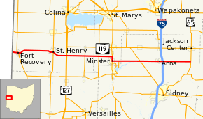
State Route 119 (SR 119) is an east–west highway serving rural sections of west-central Ohio. It begins just west of Fort Recovery at the eastern terminus of Indiana State Road 26 and intersects with State Route 49 in the virtual center of Fort Recovery. A "TO Indiana 26" shield can be seen westbound at the intersection with State Route 49. Heading east from Fort Recovery, State Route 119 intersects with State Route 118 near the eastern border of Saint Henry. Shortly thereafter, State Route 119 meets U.S. Route 127, the only U.S. highway it has an intersection with. Near the border between Mercer and Auglaize counties, it crosses State Route 716 at Maria Stein. After crossing into Auglaize County, State Route 119 intersects with State Route 364, which runs north to Grand Lake Saint Marys State Park. Next, State Route 119 meets up with State Route 66 at the northern edge of Minster. The two roads overlap for about a mile into the town, before 119 turns left onto Fourth St. Just outside of Minster, State Route 363 heads south from 119 toward Lake Loramie State Park. 119 then crosses into Shelby County and intersects with State Route 29 in McCartyville, which was 119's original eastern terminus (see below). This is also the only east–west highway that State Route 119 crosses. The road then continues east to Anna, the last town State Route 119 enters in that direction. Near the eastern outskirts of Anna, 119 has an interchange with Interstate 75. Approximately 7 miles (11 km) later, State Route 65 marks the eastern terminus of State Route 119.
Major intersections
| County | Location | mi[1] | km | Destinations | Notes |
|---|---|---|---|---|---|
| Mercer | Recovery Township | 0.00 | 0.00 | Indiana state line | |
| Fort Recovery | 1.50 | 2.41 | |||
| St. Henry | 9.62 | 15.48 | |||
| Granville–Marion township line | 12.89 | 20.74 | |||
| Marion Township | 17.02 | 27.39 | |||
| Auglaize | Jackson Township | 20.17 | 32.46 | ||
| Minster | 23.19 | 37.32 | Western end of SR 66 concurrency | ||
| 24.20 | 38.95 | Eastern end of SR 66 concurrency | |||
| Jackson Township | 25.71 | 41.38 | Northern terminus of SR 363 | ||
| Shelby | Van Buren Township | 30.53 | 49.13 | ||
| Franklin–Dinsmore township line | 35.52– 35.66 | 57.16– 57.39 | Exit 99 (I-75) | ||
| Jackson Township | 41.94 | 67.50 | |||
1.000 mi = 1.609 km; 1.000 km = 0.621 mi
| |||||
References
Route map: Bing
- ↑ 1.0 1.1 "DESTAPE". Ohio Department of Transportation. July 3, 2014. Retrieved September 9, 2014.