Ohio State Route 101
| ||||
|---|---|---|---|---|
 | ||||
| Route information | ||||
| Maintained by ODOT | ||||
| Length: | 36.53 mi[1] (58.79 km) | |||
| Existed: | 1924 – present | |||
| Major junctions | ||||
| West end: |
| |||
|
| ||||
| East end: |
| |||
| Location | ||||
| Counties: | Seneca, Sandusky, Erie | |||
| Highway system | ||||
| ||||

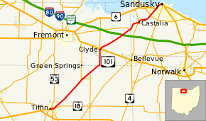
State Route 101 (SR 101) is a southwest-northeast (signed east–west) state highway in the north central portion of the U.S. state of Ohio. Its western terminus is at the junction of State Route 53 and State Route 18 in Tiffin; it runs concurrently with State Route 18 for about 1 mile (1.6 km). Its eastern terminus is at the junction of U.S. Route 6 and State Route 4 in Sandusky; it runs concurrently with U.S. Route 6 for just over 1½ miles to its western terminus.
History
- 1924 – Original route established[2]
- 1932 – 8 miles (13 km) north of Clyde to Sandusky dually certified with State Route 12.[3]
- 1970 – 8 miles (13 km) north of Clyde to Sandusky dually certified with State Route 412.[3]
- unknown – Dual certification removed 8 miles (13 km) north of Clyde to Sandusky.
Major intersections
| County | Location | mi | km | Destinations | Notes |
|---|---|---|---|---|---|
| Seneca | Tiffin | 0.00 | 0.00 | Western terminus of OH 101; western end of OH 18 concurrency | |
| Eastern end of OH 18 concurrency | |||||
| Adams Township | Southern terminus of OH 778 | ||||
| Northern terminus of OH 238 | |||||
| Sandusky | Clyde | Southern terminus of OH 510 | |||
| Townsend Township | Eastern terminus of OH 412 | ||||
| Erie | Castalia | Southern end of OH 269 concurrency | |||
| Northern end of OH 269 concurrency | |||||
| Sandusky | |||||
| Eastern terminus of OH 101 | |||||
1.000 mi = 1.609 km; 1.000 km = 0.621 mi
| |||||
References
- ↑ Ohio Department of Transportation. "Technical Services Straight Line Diagrams". Retrieved April 30, 2010.
- ↑ Explanation of the Ohio State Highway System (The Unofficial Ohio State Highways Web Site) by John Simpson
- ↑ 3.0 3.1 Route 101 (The Unofficial Ohio State Highways Web Site) by John Simpson
Route map: Bing