Ocean Observatories Initiative
The Ocean Observatories Initiative (OOI) is an National Science Foundation (NSF) Division of Ocean Sciences program that focuses the science, technology, education and outreach of an emerging network of science driven ocean observing systems. It is a networked infrastructure of science-driven sensor systems to measure the physical, chemical, geological and biological variables in the ocean and seafloor as well as the overlying atmosphere, providing a fully integrated system collecting data on coastal, regional and global scales.
Project Overview
The Ocean Observatories Initiative (OOI) is a project funded by the National Science Foundation (NSF). It is a networked infrastructure of science-driven sensor systems to measure the physical, chemical, geological and biological variables in the ocean and seafloor as well as the overlying atmosphere, providing a fully integrated system collecting data on coastal, regional and global scales.
The goal of the OOI is to deliver data and data products for a 25-year-plus time period within an expandable architecture that can meet emerging technical advances in ocean science. These data will be freely accessible online through the OOi Cyberinfrastructure.
Construction of the OOI commenced in 2009. Initial installations of scientific instrumentation will begin in summer 2013, and the project is planned to be in full operations by early 2015.
Project History
The OOI project builds on the heritage of the ship-based expeditions of the last century and the more recent emphasis to increase ocean observation and in situ monitoring.
In 2003 the Pew Oceans Commission issued a major report with recommendations designed to improve society’s use and stewardship of, and impact on, the coastal and global ocean.[1] These recommendations highlighted key areas that require continuous investigation to enable timely and sound decision-making and policy development.
In 2007 the National Science and Technology Council’s Joint Subcommittee on Ocean Science and Technology developed an Ocean Research Priorities Strategy,[2] which provides a framework for research investments to advance current understanding of critical ocean processes and interactions that facilitate responsible use of the ocean environment. The ORPS identifies three critical cross-cutting elements, one of which is ocean observing for research and management.
In late 2007 the OOI project underwent its Preliminary Design Review and in 2008 completed its Final Network Design Review resulting in the Final Network Design.[3] In May 2009, the National Science Board authorized the Director of NSF to award funds for the construction and initial operation of the OOI. In September 2009, NSF and the Consortium for Ocean Leadership signed the Cooperative Agreement that initiated the construction phase of the OOI.
Project Organizational Structure
The OOI Program is managed and coordinated by the OOI Project Office at the Consortium for Ocean Leadership, in Washington, D.C., and is responsible for construction and initial operations of the OOI network. Five Implementing Organizations are responsible for construction and development of the overall program. (1) Woods Hole Oceanographic Institution and Scripps Institution of Oceanography are responsible for the Pioneer and Global Arrays, including their moorings and autonomous vehicles. (2) Oregon State University is responsible for the Endurance Array moorings and autonomous vehicles. (3) The University of Washington is responsible for regional cabled seafloor systems and moorings. (4) The University of California, San Diego, is implementing the cyberinfrastructure component. (5) Rutgers, The State University of New Jersey, with its partners University of Maine and Raytheon Mission Operations and Services is responsible for the education and public engagement software infrastructure.
Major Science Themes
The multiple sites and platforms of the OOI components target the following key scientific processes:
Ocean-Atmosphere Exchange
Quantifying the air-sea exchange of energy and mass, especially during high winds (greater than 20 meters-per-second), to provide estimates of energy and gas exchange between the surface and deep ocean. Such measurements will improve the predictive capability of storm forecasting and climate change models.
Climate Variability, Ocean Circulation and Ecosystems
Examining how climate variability affects ocean circulation, weather patterns, the ocean’s biochemical environment, and marine ecosystems.
Turbulent Mixing and Biophysical Interactions
Understanding the role of turbulent mixing in the transfer of materials within the ocean and in the exchange of energy and gases between the ocean and atmosphere.
Coastal Ocean Dynamics and Ecosystems
The coastal ocean is host to a variety of dynamic and complex processes, and is profoundly influenced by human activities. Quantifying these processes is important for understanding and management of coastal resources in a changing climate.
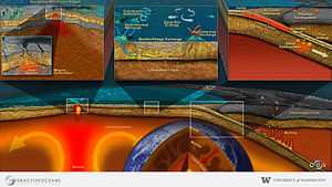
Plate-Scale, Ocean Geodynamics
Examining the degrees to which active plate boundaries influence the ocean from a physical, chemical, and biological perspective. Lithospheric movements and interactions at plate boundaries at or beneath the seafloor are responsible for short-term events like earthquakes, tsunamis, and volcanic eruptions. These tectonically active regions are also host to the densest hydrothermal and biological activity in the ocean basins.
Fluid-Rock Interactions and the Subseafloor Biosphere
The oceanic crust contains the largest aquifer on Earth. Thermal circulation and reactivity of seawater-derived fluids can modify the composition of oceanic plates, can lead to the formation of hydrothermal vents that support unique micro- and macro-biological communities, and can concentrate methane to form massive methane gas and methane hydrate reservoirs.
Components of the OOI
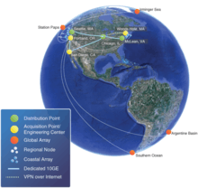
There are four main components that comprise the OOI. These include: (1) Coastal Global Scale Nodes (CGSN); (2) Regional Scale Nodes (RSN); (3) Cyberinfrastructure (CI); and (4) Education and Public Engagement (EPE). OOI Implementing organizations are responsible for the construction and development of each of these components.
Coastal Global Scale Nodes (CGSN)
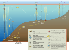
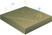
The CGSN is made up of two coastal arrays and four global arrays. Coastal arrays will provide sustained, but adaptable access to complex coastal systems. Coastal arrays extend from the highly productive continental shelf to the continental slope, allowing scientists to examine several important coastal processes including upwelling, hypoxia, shelf break fronts, and the role of filaments and eddies in cross-shelf exchange. Technologies will be employed to gather data in the coastal region including moored buoys with fixed sensors, moorings supporting vertical profilers, seafloor cables, gliders and autonomous underwater vehicles.
The coastal observatory comprises two elements: A long-term Endurance Array in the Eastern Pacific and a re-locatable Pioneer Array in the Western Atlantic. The Pioneer Array will be installed and operated by Woods Hole Oceanographic Institution. The Endurance Array will be installed and operated by Oregon State University.
Pioneer Array
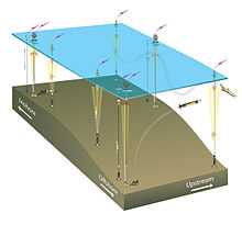
The Pioneer Array is a network of platforms and sensors operating on the continental shelf and slope south of New England. A moored array will be centered at the shelf break in the mid-Atlantic Bight south of Cape Cod, Massachusetts. Autonomous underwater vehicles (AUVs) will sample the frontal region in the vicinity of the moored array, and gliders will resolve mesoscale features on the outer shelf and the slope sea between the shelf break front and the Gulf Stream.
The Pioneer Array will provide a detailed, three-dimensional view of key biophysical interactions at the shelf break using its flexible, multiplatform array combining moored and mobile assets with high spatial and temporal resolution. With its initial location south of Cape Cod, the Pioneer Array will be embedded within an established regional observing system, providing opportunities for coordination. The Pioneer Array may be moved from place to place over approximately five-year intervals to characterize processes in different coastal ocean environments.
More information on specific instruments located at the Pioneer Array, can be found on the Pioneer Array Online Instrument Tables.
Endurance Array
The Endurance Array, located on the continental shelf and slope off Oregon and Washington, will provide a long-term network of moorings, benthic nodes, cabled and uncabled sensors, and gliders. The array will consist of two lines of moorings, one off Newport, Oregon (the Oregon Line) and the other off Grays Harbor, Washington (the Washington Line). Gliders will sample between the mooring lines. The array will focus on observing the influence of the Columbia River on the coastal ecosystem as well as sample a prototypical upwelling regime on a narrow continental shelf where anoxia events are common. Some of the Endurance Array Oregon Line infrastructure will be connected to the RSN cabled network providing enhanced power and communications for observing water column and seafloor processes.
More information on specific instruments located at the Endurance Array, can be found on the Endurance Array Online Instrument Tables.
Global Arrays
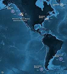
Locations of the global arrays were selected by a team of scientists (~300 people)[4] based on regions that are under-sampled and subject to extreme conditions (e.g., high winds and sea states) that pose very challenging conditions for continuous or even frequent ship-based measurements. The planned global study sites include instrumented moorings and gliders in four locations: (1) Argentine Basin; (2) Irminger Sea; (3) Southern Ocean; and (4) Station Papa. The global arrays are being developed and operated by Woods Hole Oceanographic Institution and Scripps Institution of Oceanography.
Observations from these high latitude areas are critical to examining ocean circulation and climate change processes. The global arrays each include four moorings (except Station Papa which will have three moorings) composed of fixed and moving sensors that measure air-sea fluxes of heat, moisture and momentum as well as physical, biological and chemical properties of the water column. Each array will also include gliders to sample within the array’s footprint.
More information on specific instruments located at each of the Global Arrays, can be found on the Online Instrument Tables: · Argentine Basin · Irminger Sea · Southern Ocean · Station Papa
Regional Scale Nodes (RSN)
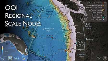
The OOI Regional Scale Nodes cabled arrays of ocean observing sensors in the Northeast Pacific Ocean will be connected by approximately 900 kilometers (560 miles) of electro-optical cable. The design of the cabled array will provide high power (10 kV, 8 kW) and bandwidth (10 GbE) to scientific sensor arrays on the seafloor and throughout the water column using moorings with instrumented wire-following profilers, 200 m instrumented platforms, and winched profilers. The RSN will be installed and operated by the University of Washington.
There will be two primary study sites within the RSN: Hydrate Ridge, an area of massive sub-seafloor gas-hydrate deposits and fluxes of methane from the seafloor into the ocean; and Axial Seamount, the most magmatically robust volcano on the Juan de Fuca Ridge spreading center that erupted in April 2011.
The RSN complements the NEPTUNE cabled observatory, operated by Ocean Networks Canada on the northern Juan de Fuca plate. Together these observatories will enable long-term, plate-scale seafloor and ocean investigations in the Northeast Pacific.
More information on specific instruments located on the Regional Scale Nodes can be found on the RSN Online Instrument Tables.
Cyberinfrastructure
The Cyberinfrastructure component of the OOI links marine infrastructure to scientists and users. The OOI Cyberinfrastructure manages and integrates data from all the different OOI sensors. It will provide a common operating infrastructure, the Integrated Observatory Network (ION), connecting and coordinating the operations of the marine components (global, regional, and coastal scale arrays). It will also provide resource management, observatory mission command and control, product production, data management and distribution (including strong data provenance), and centrally available collaboration tools.
The Integrated Observatory Network (ION) connects and coordinates the operations of the OOI marine components with the scientific and educational pursuits of oceanographic research communities. The cyberinfrastructure is being designed and constructed by the University of California, San Diego.
Education and Public Engagement (EPE)
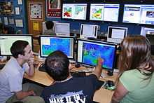
The OOI Education and Public Engagement (EPE) Implementing Organization will create a series of educational data visualization tools to engage students in active scientific inquiry. Collectively, these tools will provide easy access for the development and use of educationally appropriate scientific data visualizations, helping to translate OOI science themes into educational materials, deliver the capability to collaboratively build and edit online lesson/lab units, enable virtual collaboration and sharing of oceanographic data and learning materials, and help to facilitate broader access to data. We anticipate a variety of ways these tools will be used within lectures and labs, to provide data for homework assignments and student research papers, and for general data exploration to test scientific hypotheses. All five services will be developed and integrated into a single interface, for release in fall 2014, through a web application programming interface (API). This API will also provide a framework that other computer scientists and programmers can use to develop new educational products for the web and other mobile applications.
Specifically, the EPE will develop five online services (Table 1) including: 1) educational visualization tools, 2) an ontology-linked concept mapping tool, 3) a lab-lesson builder, 4) an educational resource database, and 5) a collaboration portal for educators.

References
- ↑ Pew Oceans Commission. May 2003. America's Living Oceans: Charting a Course for Sea Change http://www.pewtrusts.org/uploadedFiles/wwwpewtrustsorg/Reports/Protecting_ocean_life/env_pew_oceans_final_report.pdf
- ↑ National Science and Technology Council’s Joint Subcommittee on Ocean Science and Technology. 2006. Charting the Course for Ocean Science for the United States for the Next Decade: An Ocean Research Priorities Strategy (ORPP). http://www.whitehouse.gov/sites/default/files/microsites/ostp/nstc-orppis.pdf
- ↑ Ocean Observatories Initiative. 2010 Final Network Design. http://www.oceanobservatories.org/wp-content/uploads/2012/04/1101-00000_FND_OOI_ver_2-06_Pub.pdf
- ↑ Daly, K., R. Jahnke, M. Moline, R. Detrick, D. Luther, G. Matsumoto, L. Mayer, K. Raybould. May 2006. Design and Implementation Workshop Report. http://www.oceanleadership.org/wp-content/uploads/2009/07/ooi_di_report_final.pdf