Oark, Arkansas
| Oark, Arkansas | |
|---|---|
| Unincorporated community | |
 Oark, Arkansas | |
| Coordinates: 35°41′22″N 93°34′21″W / 35.68944°N 93.57250°WCoordinates: 35°41′22″N 93°34′21″W / 35.68944°N 93.57250°W | |
| Country | United States |
| State | Arkansas |
| County | Johnson |
| Elevation | 1,017 ft (310 m) |
| Time zone | Central (CST) (UTC-6) |
| • Summer (DST) | CDT (UTC-5) |
| ZIP code | 72852 |
| Area code(s) | 479 |
| GNIS feature ID | 77893[1] |
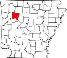
Oark is an unincorporated community in Johnson County, Arkansas, United States. Oark is located on Arkansas Highway 215, 16 miles (26 km) northwest of Clarksville. Oark has a post office with ZIP code 72852.[2] The community is surrounded by the Ozark National Forest with the scenic Mulberry River nearby. The origin of the town’s name is unknown, although many believe it came from French trappers that frequented this isolated valley in the 1700s.
History
The Mulberry River valley has been the site of human habitation for thousands of years. Archeologists believe that bluff-dwelling cultures thrived here as late as 500 B.C., and later the Osage Indians claimed the valleys drained by the Mulberry River as part of their hunting grounds. French trappers frequented the area as far back as the mid-1600s, and many Cherokee settled here and were formally given land in 1817 (although they were pressured to cede the area in 1828 and move farther west). Official white settlement of the Mulberry River valley began around 1828.
Education
Public education for elementary and secondary school students is provided by the Jasper School District, which includes:
- Oark Elementary School, serving grades K-6.
- Oark High School, serving grades 7-12.
The campus is also the site of the "Tri-Centennial Tree" - an ancient southern red oak estimated to be over 300 years old. There is a historic marker on Highway 215 in front of the school commemorating the dedication of the tree in 2012.
Tourism
Oark has numerous tourist attractions, both in the town and the surrounding area.
- Oark General Store: This local business has been in operation since 1890, making it the oldest continuously operating store in Arkansas. The store was first opened to provide supplies for area residents, but was later expanded to include a full-service restaurant as well.
- Mulberry River: This National Wild and Scenic River has Class 3 rapids at certain times of the year, and is popular for canoeing and kayaking.
- Ozark Highlands Trail: The Oark stretch of this 200-mile trail is popular for day-hikes and camping.
- Trans-America Trail: This trail also runs through Oark, offering many miles of rugged adventure for off-road enthusiasts.
References
- ↑ "US Board on Geographic Names". United States Geological Survey. 2007-10-25. Retrieved 2008-01-31.
- ↑ ZIP Code Lookup
- Banner, John C., ARKANSAS HISTORICAL QUARTERLY, Volume 19, Autumn 1960, p. 191
| |||||||||||||||||||||
