O'Connor, Australian Capital Territory
| O'Connor Canberra, Australian Capital Territory | |||||||||||||
|---|---|---|---|---|---|---|---|---|---|---|---|---|---|
 | |||||||||||||
| Population | 5,251 (2011 census)[1] | ||||||||||||
| • Density | 1,072/km2 (2,776/sq mi) | ||||||||||||
| Established | 1928 | ||||||||||||
| Postcode(s) | 2602 | ||||||||||||
| Area | 4.9 km2 (1.9 sq mi) | ||||||||||||
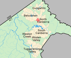
| District | North Canberra | ||||||||||||
| Territory electorate(s) | Molonglo | ||||||||||||
| Federal Division(s) | Fraser | ||||||||||||
| |||||||||||||

O'Connor is a suburb of Canberra, Australia in the North Canberra district. It was named after Richard Edward O'Connor (1851–1912), who was a judge in the High Court and a founder of the Australian constitution. Street names in O'Connor are named after explorers, Australian flora, legislators and pioneers. The suburb name was gazetted on 20 September 1928.[2]
O'Connor is bounded by Wattle and David streets, and also includes the Bruce/O'Connor ridge nature reserve, the hilly area with many trees that lies between the houses in O'Connor, and the Australian Institute of Sport (in the suburb of Bruce). Sports such as soccer, rugby and cricket are often played at the ovals at O'Connor district playing fields.
O'Connor has a small shopping centre with a pub/bar, supermarket, a couple of restaurants and a pharmacy.
Character
The suburb is characterised by leafy streets and detached single dwelling houses. In the central part of O'Connor are a series of cul de sacs which contain houses which are known as Tocumwal Houses. These are heritage listed ex-government housing which were transported from RAAF Station Tocumwal after the Second World War to cover the housing shortage in Canberra in the 1950s.[3][4]
The ACT Heritage Council has also listed the Scout Hall at the corner of Hovea Street and Boronia Drive. It was originally built as a mess hall for construction workers at Old Parliament House and was later moved to Kingston and used as an office of the United Friendly Society. In 1959, it was moved to O'Connor to become a Scout Hall.[5]
A number of Aboriginal places on the Bruce and O’Connor Ridges are also on the heritage list.[6]
The small part of the suburb to the east of Sullivans Creek is beginning to be redeveloped under a policy permitting two and three-storey flats.[7]
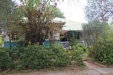 Tocumwal House in Todd Street |
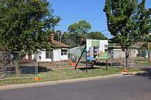 Houses being demolished to make way for three-storey units in Berrigan Crescent |
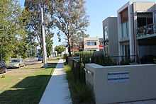 Two-storey units in Berrigan Crescent |
Suburb Amenities
The O'Connor Cooperative School (a government run early childhood school)[8] and St Joseph's primary school (run by the Catholic Church) are both located in O'Connor. The Anglican church of St Philip's in O'Connor was dedicated in 1961,[9] and consecrated in 1981. The O'Connor Ridge is a large strip of land that is use for bush walking and mountain biking and is a part of the Canberra Nature Park. At the O'Connor shops there can be found, the "Duxton" bar and restaurant, an IGA supermarket, a hairdresser, a bicycle shop, a pharmacy, a bar and restaurant the "39 Steps", and a Vietnamese restaurant the "Tu Do". Along the road from these are Canberra's Alliance Française, a Croatian Club and a Polish Club.
Demographics
In the 2011 Census, the population of O'Connor was 5,251, including 45 (0.9%) Indigenous persons and 3,756 (71.5%) Australian-born persons. 79.1% of dwellings were separate houses (compared to the Australian average of 75.6%), while 8.0% were semi-detached, row or terrace houses (Australian average: 9.9%) and 12.6% were flats, units or apartments (Australian average: 13.6%). 43.3% of the population were professionals, compared to the Australian average of 21.3%. Notably 22.8% worked in government administration, compared to the Australian average of 1.3%, although the Canberra-wide average is a very similar 20.1%. 45.2% of the population had no religion, compared to the ACT average of 28.9% and the Australian average of 22.3%.[1]
Politics
|
| ||||||||||||||||||||||||||||||||||||||||||||||||
O'Connor is located within the federal electorate of Fraser, which is currently (2014) represented by Andrew Leigh of the Labor Party in the House of Representatives. Polling place statistics are shown to the right for the O'Connor polling place at St Joseph's Primary School in the 2013 federal[11] and 2012 ACT[10] elections.
In the ACT Legislative Assembly, O'Connor is part of the electorate of Molonglo, which elects seven members on the basis of proportional representation, three Labor, three Liberal and one Greens members.[12]
Geology
Calcareous shales from the Canberra Formation is overlain by Quaternary alluvium. This rock is the limestone of the original title of Canberra "Limestone Plains". The higher parts of O'Connor in the west are different. Towards the south near Black Mountain is the Black Mountain Sandstone. Towards the north, and including O'Connor Ridge can be found Greywacke from the Ordovician age Pittman Formation.
-

O'Connor Uniting Church with solar panels
-
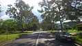
David Street, looking south west, the boundary street between Turner and O'Connor.
-
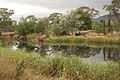
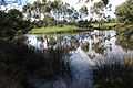
Banksia Street wetland in northern O'Connor
-
Banksia Street wetland
-
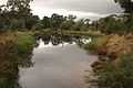
David Street wetland in southern O'Connor
References
- ↑ 1.0 1.1 Australian Bureau of Statistics (31 October 2012). "O'Connor (State Suburb)". 2011 Census QuickStats. Retrieved 27 December 2013.
- ↑ "Suburb Name search results". ACT Planning & Land Authority. Retrieved 30 January 2014.
- ↑ "The Tocumwal Archive". ACT Heritage Council. Retrieved 22 November 2010.
- ↑ "20043. Tocumwal Housing Precinct (Entry to the ACT Heritage Register)" (PDF). ACT Heritage Council. Retrieved 11 March 2014.
- ↑ "Heritage (Decision about Registration of 13th Canberra Scout Hall, O’Connor) Notice 2010" (PDF). ACT Heritage Council. Retrieved 11 March 2014.
- ↑ "20130. Aboriginal Places – Bruce and O’Connor Ridges (Entry to the ACT Heritage Register)" (PDF). ACT Heritage Council. Retrieved 11 March 2014.
- ↑ "Inner North Precinct Code" (PDF). ACT Planning and Land Authority. 29 November 2013. Retrieved 23 February 2014.
- ↑ "Welcome". O'Connor Cooperative School. Retrieved 18 February 2014.
- ↑ "History of the buildings". St Philip's Anglican Church, O'Connor. Retrieved 18 February 2014.
- ↑ 10.0 10.1 "Results for Molonglo candidates at O'Connor Polling Place". ACT Electoral Commission. 12 Feb 2013. Retrieved 18 February 2014.
- ↑ 11.0 11.1 "Federal Election 2013 - Polling Place O'Connor". Australian Electoral Commission. Retrieved 18 February 2014.
- ↑ "List of elected candidates - 2012 Election". ACT Electoral Commission. Retrieved 18 January 2014.
External links and resources
| Wikimedia Commons has media related to O'Connor, Australian Capital Territory. |
- Boland-Rudder, Hamish (31 January 2014). "A weekend in your suburb: 36 hours in O'Connor". The Canberra Times (Fairfax Media). Archived from the original on 31 January 2014.
- St Philip's Church
- St Joseph's School
- O'Connor Cooperative School
| ||||||||||
Coordinates: 35°15′33″S 149°07′16″E / 35.25917°S 149.12111°E