Nunnery Hill Incline
| Nunnery Hill Incline | |
|---|---|
 | |
| Overview | |
| Type | Funicular |
| Locale | Fineview, Pittsburgh, Pennsylvania |
| Coordinates | 40°27′36″N 80°00′22″W / 40.460°N 80.006°W |
| Operation | |
| Opening | 23 June 1888[1] |
| Closed | 1899 |
| Technical | |
| Line length | 1,100 feet (340 m)[1] |
| Track gauge | 5 ft (1,524 mm)[1] |
| Minimum radius | 250 feet (76 m)[2] |
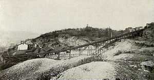
The Nunnery Hill Incline was a funicular in Allegheny City, Pennsylvania, in what is now the Fineview neighborhood of Pittsburgh. Designed by Samuel Diescher, it operated from 1888 until 1899 between its base station on Federal Street to its upper station on the currently named Meadville Street. It was one of a few inclines with a curve in the track.[3][4] The name of the hill derived from a short-lived settlement of Poor Clares earlier in the century.[5]
Remnants of the incline, namely the red brick lower station and a stone retaining wall along Henderson Street, have been subject to preservation efforts.[6]
See also
References
- ↑ 1.0 1.1 1.2 "Passenger Railways of the State of Pennsylvania". Philadelphia Securities (1893–94 ed.). Philadelphia: The Securities Press. 1893. p. 471.
- ↑ "The Inclined Planes". The Street Railway Journal Souvenir: 39. October 1891.
- ↑ "Plate 4" (Map). Real estate plat-book of the city of Allegheny. Philadelphia: G. M. Hopkins & Co. 2. 1890 – via Historic Pittsburgh.
- ↑ Diescher, Samuel (June 1897). "American Inclined Plane Railways". Cassier's Magazine 12 (2): 89.
- ↑ History of Allegheny County, Pennsylvania 1. Chicago: A. Warner & Co. 1889. p. 406.
- ↑ LaRussa, Tony (4 November 2010). "Historic designation urged for rest of Fineview incline". TribLive. Retrieved 21 March 2015.
