Nuneaton
| Nuneaton | |
 Nuneaton Town Centre |
|
 Nuneaton |
|
| Population | 81,877 (2011) |
|---|---|
| OS grid reference | SP361918 |
| District | Nuneaton and Bedworth |
| Shire county | Warwickshire |
| Region | West Midlands |
| Country | England |
| Sovereign state | United Kingdom |
| Post town | NUNEATON |
| Postcode district | CV10, CV11, CV13 |
| Dialling code | 024 |
| Police | Warwickshire |
| Fire | Warwickshire |
| Ambulance | West Midlands |
| EU Parliament | West Midlands |
| UK Parliament | Nuneaton |
|
|
Coordinates: 52°31′23″N 1°28′06″W / 52.523°N 1.4683°W
Nuneaton /nəˈniːtən/ is the largest town in the Borough of Nuneaton and Bedworth and in the English county of Warwickshire.[1] The population of Nuneaton's eleven wards in 2011 was 81,877.[2]
Nuneaton is most famous for its associations with the 19th century author George Eliot, who was born on a farm on the Arbury Estate just outside Nuneaton in 1819 and lived in the town for much of her early life. In her novel Scenes of Clerical Life (1858), "Milby" is the thinly disguised market town of Nuneaton.[3]
The Nuneaton Built-up area is a conurbation based around Nuneaton and several surrounding villages, including Hartshill and Bulkington, and had a population of 92,968 according to the 2011 census.[4] This is significantly down on the 2001 census population of 132,236,[5] the decrease occurring mainly because Hinckley no longer forms part of the built-up area.
Geography
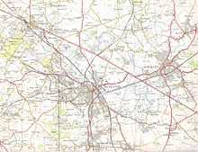
The town is located 9 miles (14 km) north of Coventry, 20 miles (32 km) east of Birmingham and 103 miles (166 km) northwest of London. The River Anker runs through the town. Nuneaton (as defined by the Office for National Statistics) had a population of 70,721 according to the 2001 census, though the 2008 estimate is closer to 73,000 inhabitants. However, both of these figures exclude the Camp Hill area of the town, which is deemed to be in the Hartshill subdivision of the Nuneaton urban area by the Office for National Statistics (ONS), as can be seen from the map included in its report on Key Statistics for urban areas[6] and the dataset of this report, which cites a population of 12,207 for the Hartshill subdivision [7] (by comparison, the population of the civil parish of Hartshill in 2001 was just 3,611 [8]). A more representative figure is given by the combined population of Nuneaton's 11 wards, which was 78,403 in 2001 according to the ONS (see table below).
Towns close to Nuneaton include Bedworth, Atherstone and Hinckley, with Tamworth and Lutterworth a little further afield. The nearest city is Coventry, 9 miles (14 km) from the centre of Nuneaton. Leicester and then Birmingham are the next closest cities. A local landmark is Mount Judd, which is a large mound of quarry residue that was formed when Judkins Quarry was dug out. Mount Judd lies in the northwest of the town and can be seen for miles around.[9] The town lies 3 miles from the Leicestershire border, 8 miles from Staffordshire and 12 miles from Derbyshire.
There are various Ordnance Survey-recognised viewpoints at the extremities of the town. One of the most noteworthy is in the west of Hartshill Hayes Country Park from where looking north Atherstone can be seen and looking northeast Leicester can be seen, depending on visibility.
History
Nuneaton's name came from a 12th-century Benedictine nunnery (parts of which still survive) around which much of the town grew. Prior to this it was a settlement known as 'Etone', which translates literally as 'water-town'. Nuneaton was listed in the Domesday Book as a small hamlet.[10] A market was established in 1233 (and is still held today). The first recorded use of the modern name was in 1247 when a document recorded it as 'Nonne Eton'. The Nunnery fell into disrepair after 1539 (with Henry VIII's Dissolution of the Monasteries). King Edward VI School was established by a royal charter in 1552.[11] From 1944 it became a grammar school for boys and, although it was locally known as KEGS, it never included the word "grammar" in its name. In 1974 it became a sixth form college. Other grammar schools in Nuneaton during the 1944 to 1974 period were Nuneaton High School for Girls and Manor Park. Additionally Nicholas Chamberlaine School in Bedworth was an early comprehensive school that had a grammar school stream.
Nuneaton grew gradually from the 17th century onwards, due to its position at the centre of the Warwickshire coalfields. At the time of the first national census in 1801 Nuneaton was already one of the largest towns in Warwickshire, with a population of 5,000.[12] During the Industrial Revolution in the 19th century, Nuneaton developed a large textile industry. Other industries which developed in the town included brick and tile making and brewing. By 1901 the population of Nuneaton had grown to 25,000.[12]
Nuneaton became an urban district in 1894, and was upgraded to the status of a municipal borough in 1907.[13]
Due largely to munitions factories located in Nuneaton, the town suffered heavy bombing damage during World War II. The heaviest bombing raid on Nuneaton took place on 17 May 1941, when 100 people were killed, 380 houses were destroyed, and over 10,000 damaged,[14] a few smaller raids took place on the town, most notably on 25 June 1942. As a result of the bombing, much of the town centre was rebuilt in the post-war years.
On 6 June 1975, six people died and 38 were injured when a train crashed just south of Nuneaton railway station.[15]
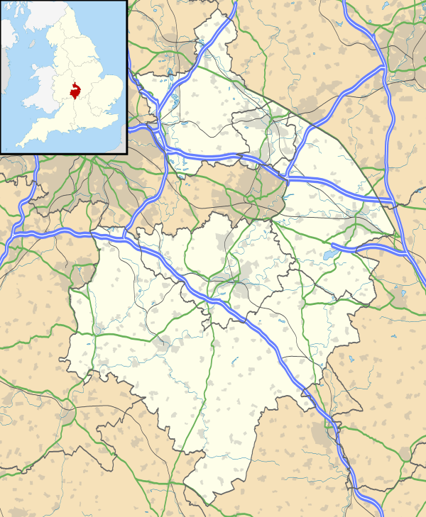
Nuneaton Abbey
An ancient abbey church founded at 'Eaton' in the 1150s was home to Benedictine nuns and gave the present town the name 'Nuneaton'.
Very little survives today of the original building. The cruciform church was sold after the Dissolution and converted into a mansion. Abandoned in the 17th century it was quarried away until all that survived by the 1860s were the foundations, some low walls and the battered crossing piers of the former central tower.
In 1876-77 this desolate ruin was brought back to life as a place of worship after centuries of neglect, when four of the original seven bays of the nave were rebuilt on the old foundations in Neo-Romanesque style by the Gothic Revival architect C.C. Rolfe with the old crossing piers enclosed by a temporary brick structure for use as a chancel. The west wall was also left in plain brick to allow for possible completion of the nave on the ancient footings further west at a later date, though this retains its incomplete appearance to this day.
In 1904 the chancel was rebuilt in neo-gothic style on the old foundations east of the crossing by Harold Brakspear, followed by the north transept in 1930. The architect had drawn up plans to restore the south transept and central tower too, but sadly these were never realised, leaving the south transept as a ruin sealed off by the 1877 'temporary' brick wall and leaving the church in an odd truncated state today (comprising half the nave, the chancel, north transept and base of the crossing).
Inside the ruined crossing piers remain from the original church, as well as part of a fine medieval tiled floor and the bases of what remained of the walls. Outside, the ruins of the nave and south transept remain as they were, along with the base of what is thought to have been a chapter house.
The church (such as it stands) is used as the Parish Church of St. Mary and is known locally as the Abbey Church.
Despite this building's significance in Nuneaton's past and its recent history, it is a relatively unknown and obscure place, with little promotion or signage.
Economy

Nuneaton's traditional industries like textiles and manufacturing have declined drastically in the post-war years. Due to its good transport links, Nuneaton is now largely a commuter town for nearby Coventry and Birmingham. However electronics and distribution remain major economic activities in the town. MIRA Limited, formerly the Motor Industry Research Association, is based on a disused wartime airfield on the A5, to the north of the town. One of the biggest developments in the town's history, the multi-million pound Ropewalk Shopping Centre, opened on 1 September 2005 in the hope that it will give the town extra income from the shopping, attract more visitors and retailers, and steer shoppers away from larger retail centres such as Birmingham, Coventry, Leicester and Solihull, with other shopping available at the longer established Abbeygate Shopping Centre located in the centre of the town. The town centre itself has undergone a successful transition from being an uninteresting 'dormitory town' service centre in the 1980s to a relatively thriving and well-planned retail and business district by the 2000s. Holland & Barrett has its headquarters based in the town while Bermuda Park, which is south of Nuneaton, is home of the national distribution centres of Dairy Crest and RS Components. As well as distribution centres, Nuneaton is also home of several international online marketing companies.
Politics
National
Nuneaton is part of the constituency of the same name in the House of Commons. The constituency is currently represented by the Conservative Party Member of Parliament (MP), Marcus Jones, who was elected in the 2010 general election. From 1935-1983 Nuneaton was a safe Labour seat, but it has since been more marginal. Between 1983 and 1992, the Conservatives held the seat, until losing it back to Labour. For the next 18 years, the Labour Party (in the form of Bill Olner) was the local representative at Parliament, until his retirement. At the 2010 general election, the parliamentary seat was taken by the Conservatives by the incumbent MP.
Local
The local council, Nuneaton and Bedworth, is currently controlled by the Labour party.[16] On 1 April 1974, as a part of wholesale local authority reorganisation, the then Nuneaton Borough Council was merged with the neighbouring Bedworth Urban District to form a new district council. Borough status was conferred on the new district on 15 November 1976. The new council was initially known as "Nuneaton Council" and then "Nuneaton Borough Council". However, in 1980, following objections from Bedworth residents, the name of the Borough was changed to "Nuneaton and Bedworth Borough Council".[17] The council was controlled by the Labour Party from 1973, when the shadow council was elected in preparation for the 1974 merger, until the 2008 local elections, when the Conservatives gained control, ending 35 years of Labour rule. (Further reading: Nuneaton and Bedworth Borough Council election, 2008) [18][19] However, the period of Conservative control was relatively short lived. The Labour Party won two seats from the Conservative Party in the 2010 local elections, giving no party overall control of the council (but leaving the Labour Party as the largest grouping). (Further reading: Nuneaton and Bedworth Borough Council election, 2010) [20] In 2012 Labour gained a further 8 seats to regain overall control. (Further reading: Nuneaton and Bedworth Borough Council election, 2012)
Nuneaton is currently covered by 11 of the borough's 17 electoral wards (see table below). Each ward elects two councillors, who serve 4 year terms. There are elections every 2 years.
| Ward name | Approximate coverage | Population (2001 census)[21] |
Population (2011 census)[21] |
|---|---|---|---|
| Abbey | Abbey Green, town centre | 7,234 [22] | 8,718 [23] |
| Arbury | Heath End, Glendale, Bermuda, Arbury | 5,482 [24] | 6,736 [25] |
| Attleborough | Attleborough, Maple Park, SW part of Whitestone | 7,564 [26] | 7,676 [27] |
| Bar Pool | Black-a-Tree, Sunnyside, Stockingford (east) | 7,451 [28] | 7,452 [29] |
| Camp Hill | Camp Hill | 7,325 [30] | 7,321 [31] |
| Galley Common | Galley Common, Chapel End, Whittleford | 7,593 [32] | 8,233 [33] |
| Kingswood | Grove Farm, Robinson's End, Stockingford (west) | 6,878 [34] | 6,878 [35] |
| St Nicolas | Horeston Grange, Hinckley Road, The Long Shoot, St Nicolas Park (south) | 7,073 [36] | 6,943 [37] |
| Weddington | Weddington, St Nicolas Park (north) | 7,286 [38] | 7,256 [39] |
| Wem Brook | Hill Top, Caldwell, Chilvers Coton | 7,082 [40] | 7,787 [41] |
| Whitestone | Whitestone (except SW part), Attleborough Fields | 7,435 [42] | 6,877 [43] |
| Total | Nuneaton | 78,403 | 81,877 |
Religion
Nuneaton's name reflects the effect that Christianity has had upon the town's history. Although the Benedictine nunnery which gave the town its name was destroyed at the time of the reformation, the remaining fragments were incorporated into the Anglican church building now known as the Abbey Church of St Mary the Virgin in Manor Court Road. This is a Victorian construction. The original ruins are left to be an obvious feature of the new building and its immediate setting.
Church of England
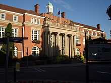
Near the town centre, but unusually not actually a part of it and outside the ring road, lies the mediaeval church of St. Nicolas- a grade I listed building.[44] Chilvers Coton contains All Saints' Church where Mary Ann Evans (George Eliot) worshipped and Justin Welby, now Archbishop of Canterbury, served as a curate.[45] This was badly damaged by bombing during the Second World War, and rebuilt largely by German prisoners of war. There are also Anglican churches in Weddington (St James's), Attleborough (Holy Trinity), Stockingford (St Paul's), Galley Common (St Peter's), Abbey Green (St Mary's), more recently built, Camp Hill (St John's).
Roman Catholic Church
There are two parishes in the town serving the Catholic community in Nuneaton. Our Lady of the Angels on Coton Road, was opened in 1838 (originally as St Mary's). The building, designed by Jospeph Hansom, was extensively remodeled in 1936. The Parish of St Anne's, Chapel End, Nuneaton was created in 1949 out of the Parish of Our Lady of the Angels (which originally covered the whole town). The original church building was replaced with the existing church, which was opened in 2000.
Other Christian traditions
In the town, Baptist, Methodist, Wesleyan Reform Union, The Church of Jesus Christ of Latter-day Saints and Pentecostal The Salvation Army and United Reformed churches can be found serving their respective congregations.
Two Kingdom Halls of Jehovah's Witnesses are located in Nuneaton.
Other world religions
In addition to Christianity, followers of Islam, Sikhism and Hinduism are also to be found among the population. There is a mosque on Frank Street, Chilvers Coton, and two gurdwaras (Sikh temples): the Nuneaton Guru Nanak Gurdwara in Park Avenue, Attleborough, and the Shri Guru Tegh Bahadur Gurdwara in Marlborough Road, Chilvers Coton.
A number of Jewish families have settled in and around Nuneaton over the past two centuries as local industries have grown and ebbed. Historically, families would travel for important life events and holidays to worship at the mediaeval Spon Street synagogue in Coventry, at the short lived Hinckley synagogue in the early 20th century and most recently, in the modern Coventry Reform synagogue. There has never been a formal, organised community in the area and most Jewish people are now elderly, with younger more observant people moving to larger communities in London and Manchester.
The Baha'i Faith was introduced to Nuneaton in the early 1970s and now has a thriving community of over 30 members. It has been instrumental in fostering multifaith and multicultural links, through activities such as the annual 'Walk of Faith' and the Interfaith Forum.
Statistics
In the 2011 Census, 63.6% of the population of Nuneaton and Bedworth said they were Christian, 24.0% of no religion, 2.3% Muslim, 2.2% Sikh, 1.1% Hindu, 0.7% Buddhist and others. 6.1% did not state their religion.[46]
Media
Radio
The local radio stations are:
- BBC Coventry & Warwickshire: 104.0FM
- Oak FM (formerly Fosseway Radio): 107.9FM
- Free Radio Coventry and Warwickshire (formally known as Mercia Sound and Mercia FM): 97.0FM
- Anker Radio - which serves the George Eliot Hospital, but can be heard on 1386am.
- BBC Radio Leicester can be received in the town on 104.9FM.
Written media
The main local newspapers are:
- The Tribune (formerly the People's Tribune (1895), Midland Counties Tribune (1903) and Nuneaton Evening Tribune (1957)): It is owned by Trinity Mirror's Coventry Newspapers (publisher of the Coventry Telegraph). Covering 'northern Warwickshire' (particularly Nuneaton, Bedworth and Atherstone), the free paper is available weekly to collect at many newsagents in the area on a Thursday or Friday.
- The Nuneaton Telegraph; a localised sub-edition of the Coventry Telegraph, it was launched in 1992 (when the aforementioned Tribune switched from daily to weekly production).
- The Nuneaton News (originally known as the Evening News upon launch and then the Heartland Evening News): Owned by Local World, it is published on weekdays. The Wednesday edition is circulated free throughout the town, whereas the daily paper on Monday, Tuesday, Thursday and Friday are paid. It was founded in 1992, following the decision of the Tribune's publisher to switch to a weekly freesheet.
Television news
The Nuneaton area is covered on regional TV News by:
Transport

The town is near the M6, the M42 and M69 motorways and the main A5 trunk road (Watling Street), which also acts as a border with Leicestershire and the neighbouring town of Hinckley. The A444 provides a high-speed dual-carriageway route into the town from the south and also acts as the often busy town centre ring road. The A47 links the town with neighbouring Hinckley and onwards to Leicester, and the A4254 - Eastern Relief Road - provides direct access from the east of Nuneaton to the south, avoiding the town centre.
Nuneaton railway station near the town centre is an important railway junction, served by the West Coast Main Line, the Birmingham to Leicester railway line and by a line to Coventry via Bedworth. It offers direct rail services to those destinations. There are plans to build a new station at Bermuda Park in the south of the town on the line towards Coventry.[47] as part of the NUCKLE (Nuneaton, Coventry, Kenilworth, and Leamington) rail upgrade scheme.
Its importance as a railway junction is underlined by the fact that Nuneaton has the third highest level of interchange passengers (after Birmingham New Street and Wolverhampton), of any railway station in the Midlands.[48] This changed in December 2008 when a new Very High Frequency (VHF) timetable was introduced by Virgin Trains on the West Coast Main Line. Virgin services now only provide services in the morning peaks and evening peaks. Instead, London Midland operate an hourly daytime service between London Euston and Crewe via Milton Keynes, Stafford and Stoke-on-Trent with journey times increased significantly, e.g. 81 minutes to Crewe versus 40 minutes on Virgin. The December 2008 timetable has been the source of much outrage locally.[49] In 2012, First Group announced plans to reintroduce an hourly service between London Euston and Chester, after (seemingly) winning the West Coast Main Line franchise. However, after the franchise was re-tendered by the DfT after apparent technical issues with the original tender, Virgin Trains were re-awarded the franchise until 2017. However there are currently services to and from Chester during the peak hours that stop at Nuneaton served by Virgin Trains.
The Coventry Canal passes through the town.
The main operators for buses in Nuneaton are Stagecoach in Warwickshire and Travel de Courcey.
Recreation

Nuneaton has two non-league football teams of note: Nuneaton Town who play in the Conference Premier and Nuneaton Griff who play in the Midland Football League Division One. There is also a thriving Sunday League football scene in the town, with teams from Nuneaton, Bedworth and North Warwickshire competing in the Nuneaton & District Sunday Football League (NDSFL).
There are three rugby union clubs in the town: Nuneaton R.F.C. (nicknamed "the Nuns"), who play in National 3 Midlands, Nuneaton Old Edwardians of Midlands 2 West (South) division and Manor Park of the Midlands 3 West (South) league.
The town is also home to Nuneaton Bowling club, where flat green bowls is played.[50]
There are three main leisure centres in the town are owned by Nuneaton and Bedworth Borough Council and managed by Everyone Active on the council's behalf (after a competitive tender process):
- The Pingles Leisure Centre - The Pingles is the main leisure centre in Nuneaton. It was rebuilt in 2004 to replace the old 1960s swimming baths. The new Pingles includes an indoor and outdoor swimming areas, a dance studio and gym. The Pingles also has an associated athletics stadium, the Pingles Stadium, which was built in 2004. The Pingles Stadium has a 250-seater stand, a running track and athletics facilities. The stadium also has a football pitch which is used by Nuneaton Griff for their home matches.
- Jubilee Sports Centre - The Jubilee Sports Centre is a sports hall. The hall is used for various sports including badminton, five-a-side football/indoor football and basketball. The Jubilee also has a scoreboard, used for major basketball and indoor football matches. The hall can be hired out for uses such as karate lessons.
- Etone Sports Centre - Etone Sports Centre is another sports hall. Etone sports hall also has astroturf football pitches which are used also for hockey. The centre is in the grounds of the school which bears the same name, Etone School, but 'Everyone Active' maintains the building.
Nuneaton has a museum and art gallery in the grounds of Riversley Park adjacent to the town centre.[51]
Despite there having been many in the town in years gone by, Nuneaton now boasts just one theatre. Run solely by volunteers, the Abbey Theatre seats 250 plus space for wheelchair patrons and hosts a very busy schedule of live performances each year.[52]
Culture
Nuneaton annually enters the Britain in Bloom competition and in 2000, Nuneaton and Bedworth was a national finalist. It is home to Nuneaton Carnival the largest in Warwickshire which takes place every June.[53]
Nuneaton was home to the smallest independent newspaper in Britain (the Heartland Evening News) until it was purchased in 2006 by life News & Media
Nuneaton has a Museum and Art Gallery within the grounds of Riversley park.
Public art in Nuneaton includes a statue of George Eliot, on Newdegate Square, and the Gold Belt.
Education
Primary
- Abbey CE Infant School (ages 4–7)
- All Saints CE Primary School (ages 4–11)
- Camp Hill Primary School (ages 4–11)
- Chetwynd Junior School (ages 7–11)
- Chilvers Coton Community Infant School (ages 4–7)
- Croft Junior School (ages 7–11)
- Galley Common Infant School (ages 4–7)
- Glendale Infant School (ages 4–7)
- Michael Drayton Junior School (in nearby Hartshill; ages 7–11)
- Middlemarch Junior School (ages 7–11)
- Milby Primary School (ages 4–11)
- Milverton House School (independent; ages 0–11)
- Nathaniel Newton Infant School (in nearby Hartshill; ages 4–7)
- Oak Wood Primary School (special school; ages 4–11)
- Our Lady of the Angels Catholic Infant School (ages 4–7)
- Park Lane Primary School (ages 4–11)
- Queen's CE Junior School (ages 7–11)
- St Anne's Catholic Primary School (ages 4–11)
- St Joseph's Catholic Junior School (ages 7–11)
- St Nicolas CE Primary School (ages 4–11)
- St Paul's CE Primary School (ages 4–11)
- Stockingford primary School (ages 4–11)
- Weddington Primary School (ages 4–11)
- Wembrook Primary School (ages 4–11)
- Whitestone Infant School (ages 4–7)
Secondary
- Etone College (ages 11–18)
- The George Eliot School (ages 11–16)
- Hartshill School of Science and the Arts (in nearby Hartshill; ages 11–16)
- Higham Lane School, Business and Enterprise Academy (ages 11–16)
- Midland Studio College (ages 14–19)
- The Nuneaton Academy, resulting from the merger of Alderman Smith School and Manor Park School (ages 11–18)
- Oak Wood Secondary School (special school; ages 11–16)
- St Thomas More Catholic School (ages 11–18)
Further Education
- King Edward VI College (ages 16–19)
- North Warwickshire and Hinckley College
- Etone Sixth Form College
George Eliot's inspirations

Many locations in George Eliot's works were based on places in or near her native Nuneaton, including:
- Milby (town and parish church, based on Nuneaton and St Nicolas parish church);
- Shepperton (based on Chilvers Coton);
- Paddiford Common (based on Stockingford, which at the time had a large area of common land including its parish Church of St Paul's);
- Knebley (based on Astley; Knebley Church is Astley Church, while Knebley Abbey is Astley Castle);
- Red Deeps (based on Griff Hollows);
- Cheverel Manor (based on Arbury Hall);
- Dorlcote Mill (based on Griff House);
- The Red Lion (based on the Bull Hotel, now the George Eliot Hotel in Bridge Street, Nuneaton);
- Middlemarch (based on Coventry);
- Treby Magna (also thought to be based on Coventry);
- Little Treby (thought to be based on Stoneleigh);
- Transome Court (thought to be based on Stoneleigh Abbey).
Twin towns
The borough of Nuneaton and Bedworth is twinned with the following towns:
Notable inhabitants
Authors
- George Eliot, Victorian novelist
- A. J. Quinnell, writer (author of Man on Fire)
Engineers
- Geoffrey de Havilland, aviation pioneer (educated at King Edward VI School)
- John Barber, inventor of the gas turbine in 1791
- John Birch, Motor cycle manufacturer and designer and constructor of the New Zealand made Marlborough car
Media and the Arts
- Ken Loach, film and television director
- Larry Grayson, comedian, entertainer and television presenter
- Mary Whitehouse, TV campaigner (born in Nuneaton)
- Ben Daniels, actor (born in Nuneaton)
- Paul Bradley, actor (born in Nuneaton)
- Jon Holmes, writer, comedian and broadcaster (grew up in Nuneaton)
- Gareth Edwards, film director, Monsters, Godzilla and the upcoming Star Wars stand alone film entitled 'Rogue one'
- Chris Emmett, comedian, notably appearing on 3-2-1
- Jamie Oliver, drummer with the UK Subs grew up in Nuneaton and went to Etone School
- Alan and Graham "Kidder" Hammonds, musicians, Incredible Kidda Band (grew up in Nuneaton and went to Alderman Smith and Manor Park Grammar School respectively)
- Martyn Bates and Peter Becker of the band Eyeless in Gaza
- Justin Welch, drummer with Britpop band Elastica (1991–2001) and a drummer for Suede in their formative years
Sport
- Stuart Attwell, youngest ever Premier League referee at 25
- Nigel Winterburn, retired footballer
- Matty Fryatt, footballer
- Adam Whitehead, Olympic swimmer
- Andy Goode, Wasps RFC & England International Rugby Union Player
- Peter Whittingham, footballer (born in Whitestone, Nuneaton)
- John Curtis, footballer
- Mick Price, snooker player
- George Reader, football referee; officiated in the final game of the 1950 FIFA World Cup
- Dean Richards, former England Rugby Union player and Rugby Union Coach (born in Nuneaton)
- Nicki Shaw, a former member of the England Women's Cricket team (born in Nuneaton)
- Julian Alsop, footballer
- Trevor Peake, footballer, 1987 FA Cup winner with Coventry City (born in Nuneaton)
- Ben Ackland, Irish cricketer (born in Nuneaton)
- Paul Best, retired cricketer [55]
Other
- Richard Freeman, cryptozoologist (born in Nuneaton)
- William Gadsby, (1773–1844) an English Baptist pastor born in Attleborough[1] who wrote many hymns.
- Cecil Leonard Knox, soldier, recipient of the Victoria Cross (born in Nuneaton)
- Andrew Copson, Chief Executive of the British Humanist Association.
Districts and suburbs of Nuneaton
Within the borough boundaries:
- Abbey Green
- Arbury
- Attleborough (including Maple Park)
- Bermuda
- Caldwell
- Camp Hill
- Chapel End (including The Shires)
- Chilvers Coton
- Galley Common
- Griff
- Grove Farm
- Hill Top
- Horeston Grange
- Robinson's End
- St Nicolas Park
- Stockingford (including Glendale, Sunnyside, Black-a-Tree, Church Farm)
- Weddington
- Whitestone (including Crowhill)
- Whittleford (including Poplar Farm, Hawthorn Common)
Outside the borough boundaries but often considered to be part of the town:
References
- ↑ OS Explorer Map 232 : Nuneaton & Tamworth: (1:25 000) :ISBN 0 319 46404 0
- ↑
- ↑
- ↑ "2011 Census - Built-up areas". ONS. Retrieved 27 July 2013.
- ↑ Table KS01 Usual resident population in Part 1"Census 2001 Key Statistics - Urban areas in the Midlands". Office for National Statistics. Retrieved 9 August 2013.
- ↑ "Census 2001: Key Statistics for urban areas in England and Wales" (PDF). Office for National Statistics. 2004. Retrieved 10 September 2009.
- ↑ "Office for National Statistics (ONS)". Statistics.gov.uk. Retrieved 22 September 2013.
- ↑ Neighbourhood Statistics. "Neighbourhood Statistics". Neighbourhood.statistics.gov.uk. Retrieved 22 September 2013.
- ↑ Garner, Tony. "Silhouetted Spoilheap". Warwickshire Photo Gallery. EnjoyWarwickshire.com. Retrieved 9 June 2008.
- ↑ Nuneaton&Bedworth.gov
- ↑ Veasey, Ted, (2002) Nuneaton: A History. Phillimore & Co Publishing ISBN 978-1-86077-215-3
- ↑ 12.0 12.1 A brief history of Nuneaton
- ↑ Visionofbritain.org
- ↑ Veasey, Ted, (2002) Nuneaton: A History ISBN 1-86077-215-3
- ↑ "Accident at Nuneaton on 6th June 1975". The Railways Archive. Retrieved 22 September 2013.
- ↑ "Election Results 2012, Local Council Results". BBC News. 19 April 2009.
- ↑ Bedworth society - Timeline
- ↑ "Election Results 2008, Nuneaton & Bedworth council". BBC News. 19 April 2008.
- ↑ The full electoral declarations can be found on the following sites: http://news.bbc.co.uk/1/shared/bsp/hi/elections/local_council/08/html/44uc.stm AND http://www.nuneatonandbedworth.gov.uk/news/general-news/local-election-results
- ↑ 2010 Local Election Results
- ↑ 21.0 21.1 "Neighbourhood Statistics - home page". Office for National Statistics. Retrieved 10 September 2009.
- ↑ Neighbourhood Statistics. "Neighbourhood Statistics 2". Neighbourhood.statistics.gov.uk. Retrieved 22 September 2013.
- ↑ Neighbourhood Statistics. "Neighbourhood Statistics 3". Neighbourhood.statistics.gov.uk. Retrieved 22 September 2013.
- ↑ Neighbourhood Statistics. "Neighbourhood Statistics 4". Neighbourhood.statistics.gov.uk. Retrieved 22 September 2013.
- ↑ Neighbourhood Statistics. "Neighbourhood Statistics 5". Neighbourhood.statistics.gov.uk. Retrieved 22 September 2013.
- ↑ Neighbourhood Statistics. "Neighbourhood Statistics 6". Neighbourhood.statistics.gov.uk. Retrieved 22 September 2013.
- ↑ Neighbourhood Statistics. "Neighbourhood Statistics 7". Neighbourhood.statistics.gov.uk. Retrieved 22 September 2013.
- ↑ Neighbourhood Statistics. "Neighbourhood Statistics 8". Neighbourhood.statistics.gov.uk. Retrieved 22 September 2013.
- ↑ Neighbourhood Statistics. "Neighbourhood Statistics 9". Neighbourhood.statistics.gov.uk. Retrieved 22 September 2013.
- ↑ Neighbourhood Statistics. "Neighbourhood Statistics 9". Neighbourhood.statistics.gov.uk. Retrieved 22 September 2013.
- ↑ Neighbourhood Statistics. "Neighbourhood Statistics 10". Neighbourhood.statistics.gov.uk. Retrieved 22 September 2013.
- ↑ Neighbourhood Statistics. "Neighbourhood Statistics 11". Neighbourhood.statistics.gov.uk. Retrieved 22 September 2013.
- ↑ Neighbourhood Statistics. "Neighbourhood Statistics 12". Neighbourhood.statistics.gov.uk. Retrieved 22 September 2013.
- ↑ Neighbourhood Statistics. "Neighbourhood Statistics 13". Neighbourhood.statistics.gov.uk. Retrieved 22 September 2013.
- ↑ Neighbourhood Statistics. "Neighbourhood Statistics 14". Neighbourhood.statistics.gov.uk. Retrieved 22 September 2013.
- ↑ Neighbourhood Statistics. "Neighbourhood Statistics 15". Neighbourhood.statistics.gov.uk. Retrieved 22 September 2013.
- ↑ Neighbourhood Statistics. "Neighbourhood Statistics 16". Neighbourhood.statistics.gov.uk. Retrieved 22 September 2013.
- ↑ Neighbourhood Statistics 17
- ↑ Neighbourhood Statistics 18
- ↑ Neighbourhood Statistics 19
- ↑ Neighbourhood Statistics 20
- ↑ Neighbourhood Statistics 22
- ↑ Neighbourhood Statistics 21
- ↑ http://www.stnicolaschurch.org.uk/building.html
- ↑ Davies, Madeleine (9 November 2012). "Welby confirmed as Williams’s successor". Church Times. Retrieved 9 February 2013.
- ↑ "Table Number KS209EW Religion, local authorities in England and Wales" (XLS). United Kingdom Census 2011. Office for National Statistics. 2011. Retrieved 9 February 2013.
- ↑ "Coventry to Nuneaton rail upgrade given go ahead". BBC News. 14 December 2011.
- ↑ "Station usage statistics, 2006-2007". Office of Rail Regulation.
- ↑ "Nuneaton and Bedworth Rail User Group".
- ↑ http://www.nuneatonbowlingclub.org.uk/
- ↑ "Museum and Art Gallery". Nuneaton and Bedworth Borough Council. Retrieved 20 October 2011.
- ↑ Welcome To The Abbey Theatre, Nuneaton
- ↑ Welcome To The website Of Nuneaton Carnival
- ↑ "Our twin cities- Cottbus". http://www.cottbus.de/. Retrieved 24 June 2013.
- ↑ http://www.espncricinfo.com/england/content/player/405682.html. Missing or empty
|title=(help)
External links
| Wikimedia Commons has media related to Nuneaton. |
| ||||||||||||||||||||||