Nuea Khlong District
| Nuea Khlong เหนือคลอง | |
|---|---|
| Amphoe | |
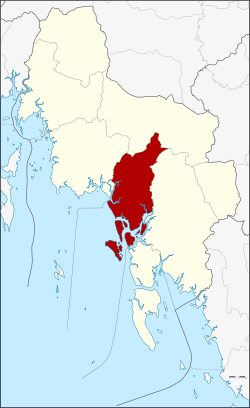 Amphoe location in Krabi Province | |
| Coordinates: 8°4′29″N 99°0′13″E / 8.07472°N 99.00361°ECoordinates: 8°4′29″N 99°0′13″E / 8.07472°N 99.00361°E | |
| Country |
|
| Province | Krabi |
| Seat | Nuea Khlong |
| Area | |
| • Total | 414.8 km2 (160.2 sq mi) |
| Population (2548) | |
| • Total | 54,789 |
| • Density | 132.1/km2 (342/sq mi) |
| Time zone | THA (UTC+7) |
| Postal code | 81130 |
| Geocode | 8108 |
Nuea Khlong (Thai: เหนือคลอง) is a district (amphoe) in Krabi Province, Thailand.
History
The minor district (King Amphoe) was created on April 1, 1992 by splitting off 8 tambon from Mueang Krabi district. [1] It was upgraded to a full district on December 5, 1996.[2]
Geography
Neighboring districts are (from the northwest clockwise) Mueang Krabi, Khao Phanom, Khlong Thom and Ko Lanta. To the west is the Andaman Sea.
Administration
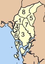
The district is subdivided into 8 subdistricts (tambon), which are further subdivided into 56 villages (muban). Nuea Khlong is a township (thesaban tambon) which covers parts of the tambon Nuea Khlong. Each tambon has a Tambon administrative organization (TAO).
|
 |
References
- ↑ ประกาศกระทรวงมหาดไทย เรื่อง แบ่งเขตท้องที่อำเภอเมืองกระบี่ จังหวัดกระบี่ ตั้งเป็นกิ่งอำเภอเหนือคลอง. Royal Gazette (in Thai) 109 (53 ง special): 1. April 22, 1992.
- ↑ พระราชกฤษฎีกาตั้งอำเภอเหนือคลอง อำเภอนายายอาม อำเภอท่าตะเกียบ อำเภอขุนตาล อำเภอแม่ฟ้าหลวง อำเภอแม่ลาว อำเภอรัษฎา อำเภอพุทธมณฑล อำเภอวังน้ำเขียว อำเภอเจาะไอร้อง อำเภอชำนิ อำเภอโนนดินแดง อำเภอปางมะผ้า อำเภอสนธิ อำเภอหนองม่วง อำเภอเบญจลักษ์ อำเภอโพนนาแก้ว อำเภอบุ่งคล้า อำเภอดอนมดแดง และอำเภอลืออำนาจ พ.ศ. ๒๕๓๙. Royal Gazette (in Thai) 113 (62 ก): 5–8. November 20, 1996.