Nouakchott
| Nouakchott نواكشوط | |
|---|---|
|
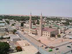
The Grand Mosque in Nouakchott. | |
 Nouakchott Map of Mauritania showing Nouakchott | |
| Coordinates: 18°6′N 15°57′W / 18.100°N 15.950°WCoordinates: 18°6′N 15°57′W / 18.100°N 15.950°W | |
| Country |
|
| Capital district | Nouakchott |
| Government | |
| • Mayor | Ahmed Hamza (2007-) |
| Area | |
| • Total | 1,000 km2 (400 sq mi) |
| Elevation | 7 m (23 ft) |
| Population (2013 census) | |
| • Total | 958,399 |
| • Density | 960/km2 (2,400/sq mi) |
Nouakchott (Arabic: نواكشوط Nuwākshūṭ, thought to derive from Berber Nawākšūṭ, "place of the winds")[1] is the capital and by far the largest city of Mauritania. It is one of the largest cities in the Sahara.[2] The city is the administrative and economic centre of Mauritania.
Nouakchott was a small village of little importance until 1958, when it was chosen as the capital of the nascent nation of Mauritania. It was designed and built to accommodate 15,000 people, but droughts since the 1970s have displaced a vast number of Mauritanians, who resettled in Nouakchott. This caused rapid urban growth and overcrowding, with the city having an estimated population of 2 million in 2008 despite the official figures being under a million. The resettled population inhabited slum areas under poor conditions, but the living conditions of a portion of these inhabitants have since been ameliorated.
Nouakchott is the hub of Mauritanian economy and is home to a port that handles 500,000 tonnes of cargo per year. A significant part of the population leads a nomadic lifestyle, setting up tents and relocating within the city. The city hosts the University of Nouakchott and several markets.
History
A tiny, fortified fishing village (ksar)[3] of 200 people[4] until 1958, Nouakchott was little mentioned during pre-colonial and colonial history. It is possible that the Berber Muslim Almoravids were originally from the area. As Mauritania prepared for independence, it lacked a capital city and the area of present-day Nouakchott was chosen by Ould Daddah and his advisors.[3] Despite its name, based on a Berber expression meaning "place of the winds",[1] the city was selected as the capital city for its moderate climate and central location in the country.[5] It also sat on one of the most valuable trade routes to West Africa.[1]

Mauritania was part of the larger French colony of French West Africa and, as such, had no capital during the colonial period: Saint-Louis, in Senegal, held that position. In 1957, this small port town was chosen to be the capital of the new country, and an ambitious building program was begun to increase its population to 15,000, starting a year later.[6] Nouakchott was still planned with the expectation that commerce and other economic activities would not take place in the city.[3] In 1958, Mauritania was formed as an autonomous republic in the French Community, and in 1960 it became an independent country, with Nouakchott as its capital.
Since independence
Nouakchott's central business was planned with broad streets and a grid-like structure, the fifth district was located close to this area and became the location of a large open-air market and residential area within a few years. During the 1960s, the city obtained its own local government. By the 1970s, these new areas had grown so much that they replaced the old ksar in terms of importance, as they also hosted the governmental buildings and state enterprises.[3]
The city was attacked in 1976 by the Polisario Front, as part of the Western Sahara independence movement.[7] Between 1988 and 1989, racial tensions between Arabs and blacks escalated. There was discrimination and retaliation by Arabs and blacks.[8]
There were three days of "bread riots" starting January 21, 1995.[8]
The city has had rapid growth, driven by the north African drought since the beginning of the 1970s: many have moved here in search of a better life.[1] The population is estimated to have been just under 1,000,000 in 2000 and to have grown to above 2,000,000 in 2008.[9]
There is currently a large amount of Chinese investment in Mauritania that is focused on the city.[1]
Geography

Located on the Atlantic coast of the Sahara Desert, it lies on the west coast of Africa, on the Atlantic Ocean. With the exception of Nouakchott Wharf and a deep water port, the coastal strip is mostly left empty and allowed to flood. The coastline includes shifting sandbanks and sandy beaches.[1] There are areas of quicksand close to the harbour.[10] Nouakchott is being covered by the sand dunes advancing from its eastern side (salmon-coloured on image to left), which pose a daily problem.[11] There have been efforts to save particular areas, including work by Jean Meunier.[12] The city is largely flat.[7]
Owing to the rapid build-up, the city is quite spread out, with few tall buildings. Most buildings are one-storey.[7] Nouakchott often acts as an interface between urban Mauritanians and their nomadic fellow citizens.
Nouakchott is built around a large tree-lined street, Avenue Gamal Abdel Nasser, which runs northeast through the city centre from the airport. It divides the city into two, with the residential areas in the north and the medina quarter, along with the kebbe, a shanty town formed due to the displacement of people from other areas by the desert.[13] Other major streets are named (in French) for notable Mauritanian or international figures of the 1960s: Avenue Abdel Nasser, Avenue Charles de Gaulle, Avenue Kennedy, and Avenue Lumumba, for example.[14]
The kebbe consists of cement buildings that are built overnight and made to look permanent to avoid destruction by the authorities. In 1999, it was estimated that more than half of the city's 1.1 million inhabitants lived in the area in tents and shacks, which were used for residential as well as business purposes.[15]
The city is broken into nine arrondissements, sub-divided into alphabetised Îlots. These are Teyarett, Ksar, Tevragh Zeïna, Toujournine, Sebkha, El Mina, Dar Naïm, Arafat and Riad. The Sebkha (Cinquième) Arrondissement is home to a large shopping area.[14]
Climate
Nouakchott features a hot desert climate (Köppen: BWh) with hot temperatures all the year, but mild winter night temperatures, because of its location close to the equator. However, Nouakchott possesses a mild temperature range compared to other cities with this climate. While average high temperatures are relatively constant at around 33 °C (91 °F), average low temperatures can range from 25 °C (77 °F) during the summer months to 13 °C (55 °F) during the winter months. Average low temperatures can be as low as 10 °C (50 °F) during winter nights in Nouakchott. Average rainfall in the city is 94 mm (3.7 in) a year.
| Climate data for Nouakchott | |||||||||||||
|---|---|---|---|---|---|---|---|---|---|---|---|---|---|
| Month | Jan | Feb | Mar | Apr | May | Jun | Jul | Aug | Sep | Oct | Nov | Dec | Year |
| Average high °C (°F) | 29.1 (84.4) |
30.6 (87.1) |
31.6 (88.9) |
32.6 (90.7) |
33.4 (92.1) |
34.6 (94.3) |
31.3 (88.3) |
32.4 (90.3) |
34.9 (94.8) |
36.4 (97.5) |
33.1 (91.6) |
29.1 (84.4) |
32.43 (90.37) |
| Daily mean °C (°F) | 21.4 (70.5) |
22.7 (72.9) |
23.9 (75) |
25 (77) |
26.2 (79.2) |
28 (82) |
27.1 (80.8) |
28.3 (82.9) |
29.7 (85.5) |
29.2 (84.6) |
25.7 (78.3) |
22 (72) |
25.77 (78.39) |
| Average low °C (°F) | 13.7 (56.7) |
14.8 (58.6) |
16.3 (61.3) |
17.5 (63.5) |
19.1 (66.4) |
21.4 (70.5) |
22.9 (73.2) |
24.2 (75.6) |
24.5 (76.1) |
22.1 (71.8) |
18.3 (64.9) |
15 (59) |
19.15 (66.47) |
| Average precipitation mm (inches) | 1 (0.04) |
2 (0.08) |
1 (0.04) |
0 (0) |
0 (0) |
1 (0.04) |
12 (0.47) |
36 (1.42) |
31 (1.22) |
7 (0.28) |
1 (0.04) |
2 (0.08) |
94 (3.71) |
| Avg. rainy days | 1 | 1 | 0 | 0 | 0 | 0 | 1 | 2 | 2 | 0 | 0 | 0 | 7 |
| Mean daily sunshine hours | 8 | 8 | 9 | 9 | 9 | 8 | 8 | 8 | 8 | 8 | 8 | 7 | 8.2 |
| Source #1: Climate-Data.org[16] | |||||||||||||
| Source #2: Weather2Travel[17] for sunshine, rainy days and another source for precipitation | |||||||||||||
Another source with different averages.
| Climate data for Nouakchott | |||||||||||||
|---|---|---|---|---|---|---|---|---|---|---|---|---|---|
| Month | Jan | Feb | Mar | Apr | May | Jun | Jul | Aug | Sep | Oct | Nov | Dec | Year |
| Record high °C (°F) | 36 (97) |
39 (102) |
41 (106) |
43 (109) |
46 (115) |
46 (115) |
43 (109) |
42 (108) |
44 (111) |
43 (109) |
42 (108) |
37 (99) |
46 (115) |
| Average high °C (°F) | 29 (84) |
31 (88) |
32 (90) |
32 (90) |
34 (93) |
33 (91) |
32 (90) |
32 (90) |
34 (93) |
33 (91) |
32 (90) |
28 (82) |
31.8 (89.3) |
| Average low °C (°F) | 14 (57) |
15 (59) |
17 (63) |
18 (64) |
21 (70) |
23 (73) |
23 (73) |
24 (75) |
24 (75) |
22 (72) |
18 (64) |
13 (55) |
19.3 (66.7) |
| Record low °C (°F) | 7 (45) |
9 (48) |
11 (52) |
12 (54) |
14 (57) |
18 (64) |
21 (70) |
20 (68) |
22 (72) |
17 (63) |
13 (55) |
7 (45) |
7 (45) |
| Average precipitation mm (inches) | 0 (0) |
3 (0.12) |
0 (0) |
0 (0) |
0 (0) |
3 (0.12) |
13 (0.51) |
104 (4.09) |
23 (0.91) |
10 (0.39) |
3 (0.12) |
0 (0) |
159 (6.26) |
| Source: BBC Weather [18] | |||||||||||||
Government

The town was first divided into districts (moughataa) in 1973. First it was divided into four. From 1986, the city was split into nine districts.[19]
- Arafat
- Dar Naim
- El Mina
- Ksar
- Riad
- Sebkha
- Tevragh-Zeina
- Teyarett
- Toujounine
Demographics

For comparison, its population was only 20,000 in 1969 and 150,000 in 1980. Part of the difficulty in estimating the city's population is that part of it is nomadic, setting up tents in suitable locations, then packing up when the need strikes. Some estimates put the 2008 population at over 2 million; more conservative estimates put that number at 800,000, estimated to be close to one-third of the country's population.[9]
Slum resettlement
In 2009, the government of Mauritania announced that it would begin a process of clearing the slum on the outskirts of Nouakchott. 24,000 families would eventually be relocated to planned housing in the city. The process was scheduled to begin with the relocation of 9,000 families from the outskirts into the poor Arafat department neighbourhood of "Kosovo", popularly named for its high crime rate and poor services. The government planned to begin moving families in June 2009 despite concerns from aid agencies that needed infrastructure cannot be put in place in the receiving neighbourhood.[20] In 2013, it was reported that "slums have been replaced by social dwellings for the poorest",[21] with the World Bank reporting that the plan met with substantial success, resulting in the access of 181,035 people in the slum areas to improved services.[22]
Infrastructure and administration
Nouakchott has a deep-sea port, opened in 1986, primarily used for imports. Annually, imports account for around 96.4% of traffic at the port. It handles 500,000[1]−800,000[4] tonnes of cargo a year. Recently, China has agreed to invest US$282 million in the port, aiming to extend the main deepwater Quay of Friendship by 500 m (1,640.42 ft).[1] A 1,100-kilometre (680 mi) road connects the city with Néma via Boutilimit and Kiffa.[1] The city also features the Nouakchott International Airport.[23]
Road transport is problematic, the main problem being overcrowding. Fuel for cars is hard to obtain in Nouakchott.[24] In the city, there is a public transport and commuter system, with vehicles serving major boulevards.[15]
An agreement was signed on August 5, 2007 between Mauritania, Sudan, and China to build a $630 million Mauritania railway linking the port of Nouakchott and phosphate mines at Bofal, about 430 km (270 mi) away. The line goes near the border with Senegal.
As of 2000, it is the home to over 30 international or diplomatic institutions.[4]
Fresh water
Although the rocks beneath the city contained a vast reservoir of fresh water, known as the Trarza Lake, it is running out, owing to the large growth of the city.[25] Engineers have warned it could run out by 2054, since it is not rain-fed, and is therefore non-renewable. The problem is particularly bad in the sandy shanty towns where the majority of the population lives.[25]
Many people already have to buy water, which is expensive compared with the average wage.[25]
Economy
Salt, cement, insecticides, rugs, carpets, embroidery, and craft products are produced in Nouakchott, with the port also exporting copper.[26] In 2000, there were over 30 small or middle-size factories in the city.[4] Administration and financial enterprises are also important.[7] There is a large sugar refinery in the city, which was has been active since 1977.[27] When Air Mauritanie existed, its head office was in the city.[28]
Nouakchott is the center of the Mauritanian economy, with three-quarters of service sector enterprises located in the city as of 1999. As of 1999, 90% of the city's economic activity consisted of informal transactions. Some inhabitants have multiple addresses and maintain strong ties with their regions of origin, at times returning for labor.[15]
Education
The city is home to the University of Nouakchott,[29] which is the only university in Mauritania and was opened in 1981. Approximately 8000 students study there; it has a considerable impact on the city, according to some. Other higher education facilities include the National School of Administration and the National Institute of Advanced Islamic Studies.
There are many primary and secondary schools, among the most prominent are the American International School of Nouakchott[30] and the Lycée Français Théodore Monod.[31]
Culture and religion


Attractions in Nouakchott include the National Museum of Mauritania, several markets including Nouakchott Silver Market, and the beaches.[14] One beach is devoted to fishing boats where fish can be bought fresh. The city hosts the National Library and National Archives. Nouakchott is the principal location in Africa for world distribution of native Saharan meteorites.
There is a mosque donated by Saudi Arabia in the city centre and a Moroccan mosque further south.[9] Although Islam is the state religion in Mauritania, Nouakchott includes the Catholic Cathedral of St. Joseph. It is home to the Roman Catholic Diocese of Nouakchott, founded in 1965.[32]
Twin towns - Sister cities
Nouakchott is twinned with:
 Madrid, Spain[33]
 Tucson, Arizona, United States
 Djibouti City, Djibouti Region, Djibouti
 Lanzhou, Gansu, China[4]
 Amman, Jordan (1999)[34]
See also
References
- ↑ 1.0 1.1 1.2 1.3 1.4 1.5 1.6 1.7 1.8 "Mauritania". OTAL. Retrieved 2009-07-08.
- ↑ http://www.livescience.com/23140-sahara-desert.html
- ↑ 3.0 3.1 3.2 3.3 Pazzanita, Anthony G. (2008). Historical Dictionary of Mauritania. Scarecrow Pres. pp. 369–372. ISBN 9780810862654.
- ↑ 4.0 4.1 4.2 4.3 4.4 Gansu Province Website-International Exchanges-Sister Cities. Accessed 25 August 2009.
- ↑ Cities of the World, Vol. 1, p331; Brian Rajewski, ed., for Eastword Publications Development Inc., Cleveland, Ohio; Gale Research, Detroit, 1999. ISBN 0-8103-7692-X.
- ↑ Nouakchott. Questia. Accessed 25 August 2009.
- ↑ 7.0 7.1 7.2 7.3 Nouakchott. LookLex. Accessed 25 August 2009.
- ↑ 8.0 8.1 Mauritania:History. LookLex. Accessed 25 August 2009.
- ↑ 9.0 9.1 9.2 Nouakchott Travel Guide. World66. Accessed 25 August 2009.
- ↑ Nouakchott, Mauritania. NASA Earth Observatory. Accessed 25 August 2009.
- ↑ Sand: The Never-Ending Story. Michael Welland. 2009. p.168.
- ↑ de Valicourt, Benedict (2000). Mauritanie. Editions Marcus. pp. 50–57.
- ↑ 14.0 14.1 14.2 The Rough Guide of West Africa. Jim Hudgens, Richard Trillo. 2003. pp.116−7
- ↑ 15.0 15.1 15.2 Lawrence, William. "Symptom of Crisis or Engine of Development? The Mauritanian Informal Economic Sector" (PDF). The Fletcher Journal of Development Studies. Retrieved 3 February 2015.
- ↑ "Climate: Nouakchott - Climate graph, Temperature graph, Climate table". Climate-Data.org. Retrieved 27 August 2013.
- ↑ "Nouakchott Climate and Weather Averages, Mauritania". Weather2Travel. Retrieved 27 August 2013.
- ↑ "Average Conditions Nouakchott, Mauritania". BBC Weather. Retrieved August 18, 2009.
- ↑ "Actualité du dimanche 01juillet 2001". Ami.mr. Retrieved 2009-07-08.
- ↑ Mauritania: City versus slum. IRIN News, UN Office for the Coordination of Humanitarian Affairs. 31 March 2009
- ↑ "The City of Nouakchott – Perspectives and Challenges". EcoMENA. Retrieved 3 February 2015.
- ↑ "Implementation Completion Report (ICR) Review - Urban Development Program". World Bank. Retrieved 3 February 2015.
- ↑ "Nouakchott International Airport (NKC)". AirGorilla. Retrieved 25 August 2009.
- ↑ Nouakchott:Place of winds. LookLex. Accessed 25 August 2009.
- ↑ 25.0 25.1 25.2 Desert capital struggles with water crisis. Medilinks. 2004. Accessed 25 August 2009.
- ↑ Nouakchott. Hutchinson encyclopedia. Accessed 25 August 2009.
- ↑ Pazzanita, Anthony G. (2008). Historical Dictionary of Mauritania. Scarecrow Pres. p. 266. ISBN 9780810862654.
- ↑ "Contact." Air Mauritanie. 15 January 2007. Retrieved on 29 July 2010.
- ↑ Home. Université de Nouakchott. Accessed 25 August 2009.
- ↑ "American International School of Nouakchott". Aisnmauritania.com. Retrieved 2013-03-12.
- ↑ "Lycée Français Théodore Monod de Nouakchott, Mauritanie". Lftm-mr.net. Retrieved 2013-03-12.
- ↑ Diocese of Nouakchott. Catholic-Hierarchy. Accessed 25 August 2009.
- ↑ Madrid city council webpage "Mapa Mundi de las ciudades hermanadas". Ayuntamiento de Madrid.
- ↑ Amman’s Relations with Other Cities. Municipality of Greater Annam. Accessed 25 August 2009.
Further reading
- Armelle Choplin et Riccardo Ciavolella, 2008. " Marges de la ville en marge du politique ? Logiques d’exclusion, de dépendance et d’autonomie à Nouakchott (Mauritanie) », Autrepart, n°45. (French)
- Choplin A., 2006. Fabriquer des villes-capitales entre monde arabe et Afrique noire: Nouakchott (Mauritanie) et Khartoum (Soudan), étude comparée. Université Paris 1, 535 p. (French)
- Choplin A., 2006. Le foncier urbain en Afrique: entre informel et rationnel, l’exemple de Nouakchott, Mauritanie, Les annales de géographie, n°647, pp. 69–91. (French)
- Anne-Marie Frérot, Nouakchott, du puits nomade à la ville des pétroliers. Risques et représentations, Maghreb-Machrek, n°190, c. December 2006 – 2007. (French)
- Philippe Tanguy, « L'urbanisation irrégulière à Nouakchott: 1960-2000 », Insaniyat, n°22, October - December 2003, (vol. VII, 4). (French)
- Diagana I., 1993. Croissance urbaine et dynamique spatiale à Nouakchott, Thèse doct.: géographie: Lyon II, 314 p. (French)
- Pitte J.-R., 1977. Nouakchott, capitale de la Mauritanie. Paris : Univ. de Paris-Sorbonne, p. 200. (French)
- Mohamed Salem Ideidbi, Mauritanie : la Richesse d'une nation, Nouakchott, al-Manar, 2011.
External links
| Wikimedia Commons has media related to Nouakchott. |
| ||||||||||||
| ||||||