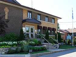
Notre-Dame-de-l'Île-Perrot
| Notre-Dame-de-l'Île-Perrot | |
|---|---|
| City | |
|
Town hall | |
|
Location within Vaudreuil-Soulanges RCM. | |
 Notre-Dame-de-l'Île-Perrot Location in southern Quebec. | |
| Coordinates: 45°22′N 73°56′W / 45.367°N 73.933°WCoordinates: 45°22′N 73°56′W / 45.367°N 73.933°W[1] | |
| Country |
|
| Province |
|
| Region | Montérégie |
| RCM | Vaudreuil-Soulanges |
| Constituted | April 14, 1984 |
| Government[2][3] | |
| • Mayor | Danie Deschênes |
| • Federal riding | Vaudreuil-Soulanges |
| • Prov. riding | Vaudreuil |
| Area[2][4] | |
| • Total | 65.60 km2 (25.33 sq mi) |
| • Land | 27.80 km2 (10.73 sq mi) |
| Population (2011)[4] | |
| • Total | 10,620 |
| • Density | 382.1/km2 (990/sq mi) |
| • Pop 2006-2011 |
|
| • Dwellings | 3,768 |
| Time zone | EST (UTC−5) |
| • Summer (DST) | EDT (UTC−4) |
| Postal code(s) | J7V |
| Area code(s) | 514 and 438 |
| Highways | No major routes |
| Website |
www |
Notre-Dame-de-l'Île-Perrot is the largest of four municipalities located on Île Perrot, west of the island of Montreal, Quebec. The population as of the Canada 2011 Census was 10,620. It hosts the island's first church built in 1740 originally situated at Pointe-du-Moulin which was reconstituted as the Chapelle du Souvenir in 1953 beside the church of Sainte-Jeanne-de-Chantal across from the town hall.
Demographics
Population
| |||||||||||||||||||
| Historical Census Data - Notre-Dame-de-l'Île-Perrot, Quebec[7] | ||||||||||||||||||||||||||
|---|---|---|---|---|---|---|---|---|---|---|---|---|---|---|---|---|---|---|---|---|---|---|---|---|---|---|
|
|
| ||||||||||||||||||||||||
Language
| Canada Census Mother Tongue - Notre-Dame-de-l'Île-Perrot, Quebec[7] | ||||||||||||||||||
|---|---|---|---|---|---|---|---|---|---|---|---|---|---|---|---|---|---|---|
| Census | Total | French |
English |
French & English |
Other | |||||||||||||
| Year | Responses | Count | Trend | Pop % | Count | Trend | Pop % | Count | Trend | Pop % | Count | Trend | Pop % | |||||
| 2011 |
10,455 |
6,890 | |
65.90% | 2,230 | |
21.33% | 235 | |
2.25% | 1,100 | |
10.52% | |||||
| 2006 |
9,865 |
7,035 | |
71.31% | 1,980 | |
20.07% | 150 | |
1.52% | 700 | |
7.10% | |||||
| 2001 |
8,530 |
6,375 | |
74.74% | 1,525 | |
17.88% | 125 | |
1.46% | 505 | |
5.92% | |||||
| 1996 |
7,020 |
5,375 | n/a | 76.57% | 1,245 | n/a | 17.73% | 105 | n/a | 1.50% | 295 | n/a | 4.20% | |||||
Infrastructure
Transportation
There is a shuttle bus service operated by CIT La Presqu'Île connecting to the Dorion-Rigaud commuter rail line.
See also
- List of cities in Quebec
References
- ↑ Reference number 385496 of the Commission de toponymie du Québec (French)
- ↑ 2.0 2.1 Ministère des Affaires municipales, des Régions et de l'Occupation du territoire: Notre-Dame-de-l'Île-Perrot
- ↑ Parliament of Canada Federal Riding History: VAUDREUIL-SOULANGES (Quebec)
- ↑ 4.0 4.1 4.2 2011 Statistics Canada Census Profile: Notre-Dame-de-l'Île-Perrot, Quebec
- ↑ "2006 Community Profiles". Canada 2006 Census. Statistics Canada. March 30, 2011. Retrieved 2014-02-01.
- ↑ "2001 Community Profiles". Canada 2001 Census. Statistics Canada. February 17, 2012. Retrieved 2014-02-01.
- ↑ 7.0 7.1 Statistics Canada: 1996, 2001, 2006, 2011 census
 |
Pincourt | L'Île-Perrot |  | |
| Lake Saint-Louis Vaudreuil-Dorion Pointe-des-Cascades |
|
Lake Saint-Louis Baie-D'Urfé Beaconsfield | ||
| ||||
| | ||||
| Lake Saint-Louis Beauharnois |
Lake Saint-Louis Léry |
Lake Saint-Louis Pointe-Claire Châteauguay |
| ||||||||||||||||||
