Norwood Mound
|
Norwood Mound | |
 | |
 | |
| Nearest city | Norwood, Ohio |
|---|---|
| Coordinates | 39°10′04″N 84°26′45″W / 39.167841°N 84.445813°WCoordinates: 39°10′04″N 84°26′45″W / 39.167841°N 84.445813°W |
| Area | 1 acre (0.40 ha) |
| Governing body | Local |
| NRHP Reference # | 74001520[1] |
| Added to NRHP | May 2, 1974 |
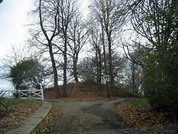
The Norwood Mound is a historic burial mound in Norwood, Ohio, United States, a suburb of Cincinnati. It was listed on the National Register of Historic Places on May 2, 1974. The mound stands about 10 feet (3.0 m), and is originally believed to have been taller.[2] No record or evidence exists of any archaeological excavation having been performed at the mound.[3]
Measurements in the 1970s recorded its dimensions as being approximately 130 feet (40 m) in length (from northeast to southwest) and 100 feet (30 m) in diameter (from northwest to southeast).[3] It is located in Tower Park at 656 ft above sea level. That site is the highest land elevation in Norwood and one of the highest elevations in all of southwest Ohio. It is believed the burial mound was built at that site due to the high elevation.
An 1895 source describes it as "the only Indian mound now remaining in the vicinity of Cincinnati."[4] There were mounds in Downtown Cincinnati at the time of arrival of the first white settlers.[5]
See also
Notes
- ↑ "National Register Information System". National Register of Historic Places. National Park Service. 2009-03-13.
- ↑ Federal Writers' Project (1943). Cincinnati, a Guide to the Queen City and Its Neighbors. p. 330. Retrieved 2013-05-04.
- ↑ 3.0 3.1 Owen, Lorrie K., ed. Dictionary of Ohio Historic Places. Vol. 1. St. Clair Shores: Somerset, 1999, 639-640.
- ↑ Kenny, Daniel J. (1895). Illustrated Guide to Cincinnati and the World's Columbian Exposition. R. Clarke. p. 245. Retrieved 2013-05-22.
- ↑ Greve, Charles Theodore (1904). Centennial History of Cincinnati and Representative Citizens, Volume 1. Biographical Publishing Company. p. 25. Retrieved 2013-05-23.
| |||||||||||||
