Norwell, Nottinghamshire
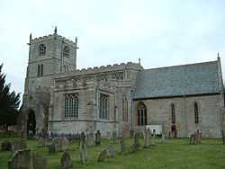
Norwell is a village and parish near Newark-upon-Trent, in central Nottinghamshire, England. It is close to the border with Lincolnshire, and approximately 1.5 miles from the A1 road and from the River Trent. The village appears in the Domesday Book as Nortwelle.[1] There is a medieval parish church dedicated to St Laurence. There is a public house called 'the Plough', a school and a village hall.
On the south side of the Church is a well-defined rectangular water-filled moat with a single causeway, into the central area, which would have given access to the medieval "Hall" or house:
"The manor house was built of timber and plaster, roofed with slates, and four rooms on the ground floor and three room on the upper storey; it stood on a mound (Mota) which was surrounded by a moat. A wooden bridge over the moat connected the house to a large outer courtyard where there were extensive outbuildings. In the North of the courtyard there were stables, and a new barn; to the South a bakery, 'hall for husbandry' and brewhouse; to the West another barn, a granary, a dovecote and gatehouse; and to the East 'le olde orcherd'."
Norwell Mill, a tower windmill west of the church, built in 1852 as a four-storey mill, was dismantled in 1920 and reduced to a three-storey stump, roofed over and used as a store. The mill was bought in 1977 and has been undergoing restoration since 1980, the tower being built up to its original height of 42 feet.[2][3]
See also
References
- ↑ Ekwall, Eilert, The Concise Oxford Dictionary of English Place-Names. Oxford, Oxford University Press, 4th edition, 1960. p. 345. ISBN 0198691033.
- ↑ Pevsner, Nikolaus. 1979. The Buildings of England:Nottinghamshire.Harmondsworth, Middx. Penguin.
- ↑ Shaw, T. (1995). Windmills of Nottinghamshire. Page 31. Nottingham: Nottinghamshire County Council. ISBN 0-900986-12-3
External links
![]() Media related to Norwell, Nottinghamshire at Wikimedia Commons
Media related to Norwell, Nottinghamshire at Wikimedia Commons
Coordinates: 53°08′N 0°51′W / 53.133°N 0.850°W
