Norwegian County Road 55
County Road 55 (Norwegian: Fylkesvei 55) is a 248.1-kilometer (154.2 mi) long highway which runs between Lom and Høyanger in Norway. The 108-kilometer (67 mi) section across Sognefjellet, known as Sognefjellsvegen, is designated a National Tourist Route.[1][2] Also a short section at Balestrand is a National Tourist Route.[3][4] The road reaches the highest altitude on the public road network in Norway, 1434 m, and it is closed every winter.
Prior to 2010, the road was part of National Road 55 (Norwegian: Riksvei 55). The road has importance as part of the shortest route between Trondheim and Bergen, 636 km, including a ferry. Usually a faster route is used, like those including road 51 (663 km, also closed in winter, no ferry), road 15 (701 km, one ferry, used by express buses) or E39 (671 km, four ferries).
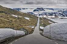
The road on Sognefjellet
References
Coordinates: 61°34′28″N 8°2′0″E / 61.57444°N 8.03333°E / 61.57444; 8.03333


