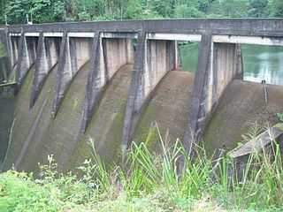
Norton Dam
| Norton Dam | |
|---|---|
 | |
| Country | Sri Lanka |
| Location |
Norton Bridge, Central Province |
| Coordinates | 06°54′50″N 80°31′18″E / 6.91389°N 80.52167°E |
| Purpose | Power |
| Status | Operational |
| Opening date | December 1950 |
| Owner(s) | Ceylon Electricity Board |
| Dam and spillways | |
| Type of dam | Gravity dam |
| Impounds | Kehelgamu Oya |
| Reservoir | |
| Creates | Norton Reservoir |
| Max. length | 650 m (2,130 ft) |
| Max. width | 280 m (920 ft) |
| Power station | |
| Name | Old Laxapana Power Station |
| Coordinates | 06°55′07″N 80°29′30″E / 6.91861°N 80.49167°E |
| Turbines |
3 × 8.33 MW 2 × 12.50 MW |
| Installed capacity | 50 MW |
The Norton Dam (also sometimes called the Norton Bridge Dam) is a small gravity dam built across the Kehelgamu Oya, which is a major tributary to the Kelani River. The dam is built at Norton Bridge, in the Central Province of Sri Lanka.[1]
Reservoir and power station
The dam creates the relatively small Norton Reservoir, which is sustained by water from the Kehelgamu Oya, and water discharged from the Wimalasurendra Hydroelectric Power Station, which is located at the site of the reservoir.[1]
Water from the Norton Reservoir is further channelled through a penstock to the Old Laxapana Hydroelectric Power Station, located 3.8 km (2.4 mi) downstream at 06°55′07″N 80°29′30″E / 6.91861°N 80.49167°E, 1.5 km (0.9 mi) northwest of Kiriwan Eliya. The power station consists of five hydroelectric generators, three of which are rated at 8.33 MW, and two of which are 12.50 MW. The first three and last two units were commissioned in December 1950 and December 1958, respectively.[1][2]

See also
| Wikimedia Commons has media related to Norton Dam. |
References
- ↑ 1.0 1.1 1.2 "CEB Hydropower Generation". Ceylon Electricity Board. Retrieved 18 January 2014.
- ↑ "CEB Generation Details: Laxapana Complex". Ceylon Electricity Board. Retrieved 18 January 2014.
| ||||||||||||||||||||||||||||||||||||||||||||