North Tipperary
| North Tipperary Tiobraid Árann Thuaidh | |
|---|---|
| County | |
 | |
| Country | Ireland |
| Province | Munster |
| County town | Nenagh |
| Government | |
| • Type | County council |
| Area | |
| • Total | 2,046 km2 (790 sq mi) |
| Population (2011) | 70,322 |
| Car plates |
T (since 2014) TN (1987–2013) |
North Tipperary (Irish: Tiobraid Árann Thuaidh) was a county in Ireland. It was part of the Mid-West Region and was also located in the province of Munster. It was named after the town of Tipperary and consisted of 48% of the land area of the traditional county of Tipperary. North Tipperary County Council was the local authority for the county. In 2011, the population of the county was 70,322.[1] It was abolished on 3 June 2014.[2][3]
Geography and political subdivisions
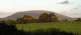
The region is part of the central plain of Ireland, but the diversified terrain contains several mountain ranges: the Arra Hills, Silvermine Mountains and the Devil's Bit. The county is landlocked. The southern part of county is drained by the River Suir; the northern part is drained by tributaries of the River Shannon which widens into Lough Derg. The centre is known as 'the Golden Vale', a rich pastoral stretch of land in the Suir basin which extends into counties Limerick and Cork.
Population centres include Nenagh (the county town), Borrisoleigh, Templemore, Thurles and Roscrea.
Baronies
There are six historic baronies in North Tipperary: Eliogarty, Ikerrin, Ormond Upper, Ormond Lower, Owney and Arra and Kilnamanagh Upper.
Civil parishes and townlands
Civil parishes in Ireland were delineated after the Down Survey as an intermediate subdivision, with multiple townlands per parish and multiple parishes per barony. The civil parishes had some use in local taxation and were included on the nineteenth century maps of the Ordnance Survey of Ireland.[4] For poor law purposes District Electoral Divisions replaced the civil parishes in the mid-nineteenth century. There are 86 civil parishes in the county.[5]
Politics and local government

The historic county of Tipperary was divided in 1898 when the administrative county of Tipperary (North Riding) was established. The North Riding had existed as a judicial county following the establishment of assize courts in 1838. The county's name changed to North Tipperary, and the council's name to North Tipperary County Council, under the Local Government Act 2001. The Council oversees the county as an independent local government area. Per Schedule 8 of the same Act, the Council resolved to give to the office of its chairperson and vice-chairperson the title of "Mayor" or "Deputy Mayor", respectively. The Council is made up of 21 representatives, directly elected through the system of proportional representation by means of a single transferable vote. The present Council was elected at the local elections held in June 2009.
The functions of the Council are divided into reserved and executive functions. Reserved functions are carried out by the members and relate primarily to policy issues, including the county development plan and the annual budget. Executive functions are the responsibility of the county manager. These include the day-to-day administration of services.
Under the provisions of the Local Government Act 1991, (Regional Authorities) (Establishment) Order, 1993,[6] the territory of North Tipperary is defined as being in the Mid-West Region. This region is a NUTS III region of the European Union. The county of South Tipperary, by contrast, is part of the South-East Region. At a NUTS II level, both counties are in the Southern and Eastern region.
The county forms the bulk of the constituency of Tipperary North along with portions of counties South Tipperary and Offaly. The constituency returns 3 deputies to Dáil Éireann. For elections to the European Parliament, the county is part of the South constituency which returns three MEPs.
The Council also claims the title of The Premier County,[7] a title which was usually taken to refer to the undivided territory of both north and south Tipperary. Following the division of the original county, North Tipperary was not granted its own coat of arms.
References
- ↑ Census of Ireland, 2011. Central Statistics Office, "Actual and Percentage Change in Population by Aggregate Town or Rural Area, Sex, Province County or City, Statistical Indicator and Census Year".
- ↑ Tipperary County Council Tipperary County Council, 2014-05-29. Quote: "Tipperary County Council will become an official unified authority on Tuesday, 3rd June 2014. The new authority combines the existing administration of North Tipperary County Council and South Tipperary County Council."
- ↑ http://www.irishstatutebook.ie/pdf/2014/en.act.2014.0001.pdf
- ↑ "Interactive map (civil parish boundaries viewable in Historic layer)". Mapviewer. Ordnance Survey of Ireland. Retrieved 9 March 2010.
- ↑ Placenames Database of Ireland - Tipperary civil parishes.
- ↑ Official Irish Statues website. Local Government Act 1991, (Regional Authorities) (Establishment) Order.
- ↑ Introduction to North Tipperary
| ||||||||||||||||||||||||||
