North Spokane Corridor
| ||||
|---|---|---|---|---|
| U.S. Route 395 North Spokane Corridor | ||||
|
The North Spokane Corridor | ||||
| Route information | ||||
| Maintained by WSDOT | ||||
| Length: |
5.42 mi[1] (8.72 km) Planned: 10.5 miles (16.9 km) | |||
| Major junctions | ||||
| South end: |
| |||
|
| ||||
| North end: |
| |||
| Highway system | ||||
| ||||

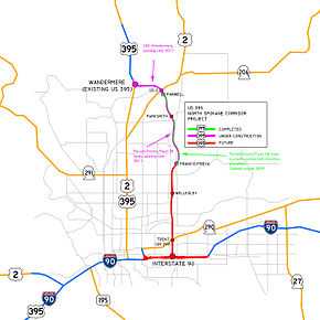
The U.S. Route 395 North Spokane Corridor (NSC) is a $2.2 billion (2009 dollars) limited-access highway project in Spokane, Washington, that is designed to improve freight and commuter mobility through the Spokane Metropolitan Area. The project by the Washington State Department of Transportation (WSDOT) will construct a freeway with a speed limit of 60 mph (97 km/h) along a new alignment starting at Interstate 90 (I-90), running northward 10.5 miles (16.9 km) toward the existing US Route 395 (US 395) just north of the Wandermere area. When completed, the multi-modal facility is expected to have general travel lanes, with right-of-way reserved for a future high-capacity transit system with park-and-ride lots. Additionally, a pedestrian and bicycle trail will run along the entire highway alignment.[2] The project is ranked 19 of 43 on the Congressional High Priority Corridor list of the National Highway System.[3] When completed, the corridor is expected to carry over 150,000 vehicles per day.[4]
History
Plans for a North Spokane Freeway date back to 1946. Earlier projects were cancelled due to other priorities and local opposition. The current project began construction in 2001.
Early plans
The idea of having a freeway run northward through Spokane was originally conceived in 1946 after the Spokane traffic survey that year. The city of Spokane needed some sort of a major north–south traffic facility to relieve congestion. After several reports and studies, the first plans for the freeway were released in 1956 with an estimated cost of just $13 million, however, those plans were quickly shelved in 1958 as the construction of the Interstate Highway System was prioritized over the construction of the north–south freeway. As a result, cheaper alternatives, such as one-way paired couplets, were discussed.
In 1964, the Spokane Metropolitan Area Transportation Study (SMATS) was formed to fulfill requirements of Federal Highway Act of 1962, and in 1970, along with the Department of Highways, released the “Corridor Study for North Spokane and North Suburban Area Freeway”. It recommended a north–south freeway along Hamilton and Nevada streets (the corridor between Nevada and Helena). Though a full freeway interchange was built connecting Hamilton Street with I-90 (exit 282/282A, connecting to State Route 290, SR 290), residents successfully blocked any further construction through this area.
Current project
After 33 years of further discussions and proposals, the final environmental impact statement (FEIS) for the current version of the project was approved in April 1997. The first phase of the NSC finally broke ground in 2001 and the first ribbon cutting ceremony (for a 3.5-mile (5.6 km) segment of lanes between the Francis/Freya and Farwell interchanges) occurred on the eighth anniversary of the ground breaking, August 22, 2009. To reduce costs, the scope of construction was reduced in 2008, reducing the northmost portion from six lanes to four, eliminating part of the interchange at Wellesley Avenue, and constructing the freeway at ground level, rather than below. This reduced the cost of that portion from $720 million to $285 million, while still allowing for those improvements later.[5]
Current progress
On June 13, 2012, the NSC opened a new section from the newly constructed interchange at US 2 to the new Wandermere/US 395 interchanges and lanes that link them, creating a free-flowing freeway segment from the US 395 interchange to the Francis/Freya interchange. Currently, the permanent southbound lanes are under construction and the northbound lanes are reduced to share with southbound traffic. This segment was completed in 2012 and includes the southbound lane section and a second roundabout for southbound traffic at Freya Street.[6] The final project on the north half of the 10-mile route was the Parksmith Road Interchange.[7] The new interchange, near the community of Mead, was opened in October, 2012. The freeway is now fully built from the Freya interchange to the Wandermere interchange. Commuters are also expected to use the newly opened segment as a faster way to access Bigelow Gulch, which leads to Argonne Road, where it leads to I-90. Traffic on Bigelow Gulch Rd is expected to increase.[8]
In Spokane's East Central district, the property acquisition process has been ongoing since June 2010 and includes the acquisition and demolition of a number of homes, businesses and industrial buildings.
Also under construction is the first project in the south half of the corridor, the Francis Avenue Bridge replacement. The project consisted of removing the existing four-lane, 160 foot long bridge and constructing a 455-foot long, five-lane structure. The new bridge will provide enough space for the future freeway lanes and railway lines to pass under Francis Avenue. The Francis Avenue Bridge opened to traffic in November, 2013.[9]
In June, 2012, WSDOT received TIGER Grant funding for the next project, which includes further construction of the Children of the Sun Trail into Hillyard, plus realignment of the railroad mainline and spur under the new structure. Work on this project is underway and expected to be completed in 2015.
Impacts
The highway is expected to significantly improve traffic through north Spokane. In particular, the highway will allow trucks to avoid congested Division Street, formerly the only north–south truck route through the city. By moving cars from congested streets to a freeway, WSDOT predicts that it will reduce auto emissions by 3.6% annually and save a million gallons of fuel a year. It will also reduce predicted traffic growth on Interstate 90, as new residents move to the North Spokane area instead of elsewhere along the Interstate.[10]
There are 62 known or suspected hazardous waste sites in the freeway's path.[10]
A 1997 report by WSDOT noted that the construction of the southern portion of the freeway will require the demolition of over 500 homes and 100 business, necessitating the relocation of over 1,000 residents.[10] Many of these homes and business are in the poorest and most ethnically diverse neighborhoods of the city.[10] WSDOT purchased many properties in Hillyard and other neighborhoods in 2002. Businesses have been allowed to remaining operating until construction actually begins. Ziggy's store will be closed in 2010 after 45 years in business because of the construction of the freeway.[11] Homes and churches[10] have also been relocated.[12]
Based on history with the construction of Interstate 90, it is forecast that the North Spokane Corridor will result in substantial land-use changes in the area.[13] The completion of I-90 resulted in growth in eastern suburbs that were once small towns, while many neighborhoods in the center of the city experienced poverty and decline. It is predicted that growth and development will occur near the interchanges of the new freeway while areas near connecting sections will remain poor neighborhoods. Whether modern growth management laws will prevent sprawl in northern suburbs is far from certain.[13] The environmental impact statement predicted more development in Pend Oreille County and Deer Park north of the city.[10]
Route description
It will run from I-90 just east of Downtown Spokane northward about 10.5 miles (16.9 km), and will meet the existing US 395 just north of Spokane at Wandermere. However in the late 1990s, a new bridge was built across the Little Spokane River, and a freeway interchange was added at Hatch Road. Upon completion of the North Spokane Corridor, it is likely that no distinction will be made for the earlier section, and the freeway will be seen as running from I-90 to Hatch Road. Beyond Hatch Road, an additional 3.3 miles was widened to four lanes, with minimal cross traffic.
The North Spokane Corridor is planned to bypass the busy Division Street corridor. The new freeway will carry the US 395 designation, and run about one mile (1.6 km) east of where it was originally planned in the 1960s and 1970s.
While the new freeway would also be a good routing for US 2 to bypass Spokane, that highway is scheduled to stay on its current routing in order to keep most of Division Street in the state highway system. Nevertheless, it will be easy for motorists on US 2 to avoid this by using the freeway instead of Division Street. On the north side, a full interchange has been constructed at US 2 in the Mead area near Farwell Road. This route uses the entire North Spokane Corridor except the northernmost one mile (1.6 km) section between US 2 and Wandermere. Division street between the "Y" (historical US 395 and US 2 split) and Wandermere will no longer be in the state highway system. This includes about one-half mile of the new section of Division Street just north of Farwell Road.
Major intersections
Currently, the freeway is open with reduced lanes from Freya Street (0.4 miles north of Francis Avenue) to the Newport Highway (US 2). The connection to Wandermere and the bridge over the Little Spokane River was complete and opened on June 13, 2012. The optional detour to connect from US 395 at Division Street and Francis Avenue to the North Spokane Corridor (NSC) on Freya Street is nearly three miles. However, Freya is a through street beginning from the Spokane River.
The entire route is in Spokane County.
| Location | mi[1] | km | Exit | Destinations | Notes | |
|---|---|---|---|---|---|---|
| Proposed southern terminus | ||||||
| Wellesley Avenue | ||||||
| 0.00 | 0.00 | Francis Avenue (via Freya Street) | Southern terminus of built section | |||
| 2.49 | 4.01 | Parksmith Drive | ||||
| 3.69 | 5.94 | |||||
| 3.90 | 6.28 | Northbound exit at US 2 and southbound exit at Shady Slope Rd. | ||||
| 5.42 | 8.72 | Northern terminus; northbound entrance and southbound exit | ||||
1.000 mi = 1.609 km; 1.000 km = 0.621 mi
| ||||||
The southbound Newport Highway (US 2) has a different connection to the NSC from that of the northbound.
- US 2 south to NSC south: Connector via Shady Slope Road with a full intersection at Farwell Road prior to entry.
- US 2 south to NSC north: This has no direct on-ramp. Requires a left turn at both Farwell Road and the Farwell Road northbound NSC on-ramp.
See also
- Washington Roads portal
References
- ↑ 1.0 1.1 Finch, Mark, ed. (January 15, 2015). State Highway Log: Planning Report 2014, SR 2 to SR 971 (PDF) (Report). Washington State Department of Transportation. pp. 1437–1440. Retrieved February 23, 2015.
- ↑ Staff. "Multi Modal Facility". US 395—North Spokane Corridor. Washington State Department of Transportation. Retrieved November 10, 2011.
- ↑ Staff. "NSC Quick Facts". US 395—North Spokane Corridor. Washington State Department of Transportation. Retrieved November 10, 2011.
- ↑ What are the benefits?, http://www.wsdot.wa.gov/NR/rdonlyres/6ABA0621-33AF-4350-B3C6-D0BFF4C5D21D/0/Benefits.pdf
- ↑ Roesler, Richard (November 25, 2008). "Plan slashes north-south freeway cost". The Spokesman Review (Spokane, WA). Retrieved November 10, 2011.
- ↑ Staff. "US 395—North Spokane Corridor". Washington State Department of Transportation. Retrieved November 30, 2011.
- ↑ "Parksmith interchange completion marks halfway point in North Spokane Corridor project". Washington State Department of Transportation. September 19, 2012.
- ↑ Staff (January 2006). "Chapter 2: What is the purpose of the Urban Connector and why do we need it?" (PDF). Environmental Assessment and Draft Section 4(f) Evaluation: Bigelow Gulch/Forker Road Urban Connector (PDF). Spokane County, Washington. pp. 2–1–2–6. Retrieved November 30, 2011.
- ↑ "No more bumps in the road: Francis Ave. Bridge opens to traffic soon". Washington State Department of Transportation. November 5, 2013.
- ↑ 10.0 10.1 10.2 10.3 10.4 10.5 Hansen, Dan (June 1, 1997). "North-south freeway to exact quite a toll". The Spokesman Review (Spokane, WA). Retrieved November 10, 2011.
- ↑ Dall, Tania (October 29, 2010). "Hillyard businesses clear out for North South Freeway". Spokane, WA: KXLY-TV. Retrieved November 10, 2011.
- ↑ Wintermeyer, Jay. "New Name, Same Family". Upper Columbia Conference of Seventh-Day Adventists. Retrieved November 10, 2011.
- ↑ 13.0 13.1 Grimes, William. "Learning from I-90: The North–South Freeway's Implication for Urban Form" (PDF). Studio Cascade Community Planning and Design. Retrieved November 10, 2011.