North Quincy (MBTA station)
NORTH QUINCY | |||||||||||
|---|---|---|---|---|---|---|---|---|---|---|---|
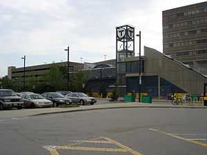 The Hancock Street entrance to the T station and its associated parking lot | |||||||||||
| Location |
East Squantum Street between Newport Avenue and Hancock Street North Quincy, Massachusetts | ||||||||||
| Coordinates | 42°16′33″N 71°01′49″W / 42.2758°N 71.0302°WCoordinates: 42°16′33″N 71°01′49″W / 42.2758°N 71.0302°W | ||||||||||
| Owned by | Massachusetts Bay Transportation Authority | ||||||||||
| Line(s) | |||||||||||
| Platforms | 1 island platform | ||||||||||
| Tracks | 2 | ||||||||||
| Construction | |||||||||||
| Parking | 1,200 spaces | ||||||||||
| Bicycle facilities | 43 spaces | ||||||||||
| Disabled access | Yes | ||||||||||
| History | |||||||||||
| Opened | September 1, 1971 | ||||||||||
| Traffic | |||||||||||
| Passengers (2009) | 7,132 (weekday boardings)[1] | ||||||||||
| Services | |||||||||||
| |||||||||||
North Quincy is a station on the MBTA Red Line rapid transit line, located at East Squantum Street between Hancock Street and Newport Avenue in Quincy, Massachusetts. It serves North Quincy High School, the State Street Bank complex, and the North Quincy and Montclair neighborhoods. Its other facilities include bus connections at street level and a 1,200-space parking lot. It opened in 1971 along with Wollaston and Quincy Center as the first section of the South Shore Line section of the Red Line.[2] North Quincy is the northernmost station on the Braintree Branch.
Bus connections
- 201 Fields Corner or North Quincy station - Fields Corner via Neponset Avenue and Adams Street (weekend service only)
- 202 Fields Corner or North Quincy Station - Fields Corner via Adams Street to Neponset Avenue (weekend service only)
- 210 Quincy Center station - North Quincy station or Fields Corner station via Hancock Street and Neponset Avenue
- 211 Quincy Center station - Squantum via Montclair and North Quincy station
- 212 Quincy Center station - North Quincy station via Billings Road
Accessibility
North Quincy station is wheelchair accessible. See MBTA accessibility.
Station layout
| G | Street Level | Exit/Entrance |
| M | Mezzanine | Fare control, to entrances/exits |
| P Platform level |
Inbound | ← Red Line toward Alewife (JFK/UMass) |
| Island platform, doors will open on the left | ||
| Outbound | → Red Line toward Braintree (Wollaston) → | |
| Commuter rail track | ← Commuter rail lines/CapeFLYER do not stop here → | |
| Commuter rail track | ← Commuter rail lines/CapeFLYER do not stop here → | |
Gallery
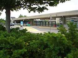
The East Squantum Street entrance and bus stop
References
- ↑ "Ridership and Service Statistics" (PDF). Massachusetts Bay Transportation Authority. 2010. Retrieved 14 January 2012.
- ↑ Belcher, Jonathan (31 December 2011). "Changes to Transit Service in the MBTA district" (PDF). NETransit. Retrieved 14 January 2012.
External links
| Wikimedia Commons has media related to North Quincy (MBTA station). |
| ||||||||||||||||||||||||||||||||||||||||||||||||||||||||||