North Fork Toutle River
| North Fork Toutle River | |
 Sediment retention dam | |
| Country | United States |
|---|---|
| State | Washington |
| County | Skamania, Cowlitz |
| Source | Spirit Lake (before 1980) |
| - location | Mount St. Helens National Volcanic Monument, Gifford Pinchot National Forest, Skamania County |
| - elevation | 3,449 ft (1,051 m) [1] |
| - coordinates | 46°15′54″N 122°09′39″W / 46.26500°N 122.16083°W [2] |
| Mouth | Toutle River |
| - location | near Toutle, Cowlitz County |
| - elevation | 443 ft (135 m) [2] |
| - coordinates | 46°19′40″N 122°43′00″W / 46.32778°N 122.71667°WCoordinates: 46°19′40″N 122°43′00″W / 46.32778°N 122.71667°W [2] |
| Length | 39 mi (63 km) [3] |
| Basin | 302 sq mi (782 km2) [3] |
 Location of the mouth of North Fork Toutle River in Washington
| |
The North Fork Toutle River is a tributary of the Toutle River in southwestern Washington in the United States. The river has its headwaters near Spirit Lake, on the north side of Mount St. Helens, and flows 39 miles (63 km) to the Toutle River,[3] about 17 miles (27 km) upstream of its confluence with the Cowlitz River.[4] The largest tributary is the Green River, which joins near the unincorporated town of Toutle.
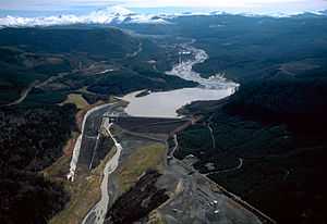
The North Fork's watershed was severely affected by the 1980 eruption of Mount St. Helens, which coated the valley with ash and filled it with successive mudflows. The result of the eruption was that many hillsides were stripped of forest, and as a result erosion has increased dramatically and the North Fork is now extremely laden with sediment. Previously, Spirit Lake was the source of the river, but eruptions blocked the outlet and Spirit Lake no longer drains directly into the North Fork; instead, a tunnel was excavated in 1985 to connect the lake with South Coldwater Creek, a tributary of the North Fork. Once a mature river, the North Fork has transformed into a braided stream of relatively young origin, and its valley floor is less than three decades old. The Toutle River Sediment Retention Structure was built by the U.S. Army Corps of Engineers on the river in 1989 to prevent this sediment from traveling downstream and clogging the shipping channel of the Columbia River.
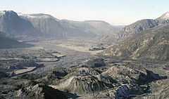
Rapid erosion of the Toutle River sediments after the 1980 eruption, creating what they call the "Little Grand Canyon of the Toutle", is cited by creationists like Ken Ham as evidence that catastrophic floods created the Grand Canyon on the Colorado River,[5][6][7][8][9] Rapid changes at Mount St. Helens are displayed as evidence of young-Earth creationism at the Creation Museum in Kentucky and 7 Wonders Museum in Washington State.[10] However this is has been widely criticised by geologists, and the mud and ash deposits laid down by the 1980 eruption are far more easily carved through than the granite of the Grand Canyon.[11] [12]
The upper part of the North Fork Toutle River watershed was redirected to the crater of Mount St. Helens itself until 1982. The river's headstreams begin on a volcanic ash deposit roughly 3 miles (5 km) long and 200 feet (61 m) deep, which is the source of much of the excess sediment.
See also
References
- ↑ Source elevation derived from Google Earth search using GNIS source coordinates.
- ↑ 2.0 2.1 2.2 "North Fork Toutle River". Geographic Names Information System (GNIS). United States Geological Survey. September 10, 1979. Retrieved January 27, 2013.
- ↑ 3.0 3.1 3.2 "Summary of Drainage Basin and Channel Characteristics Toutle River System, Mount St. Helens, Washington, 1980–1985 Water Years". United States Geological Survey. June 10, 2008. Retrieved January 27, 2013.
- ↑ United States Geological Survey. "United States Topographic Map". TopoQuest. Retrieved January 27, 2013. River miles are marked and numbered on the relevant map quadrangles.
- ↑ Steven A. Austin (1986), "Mt. St. Helens and Catastrophism", Acts&Facts (Institute for Creation Research)
- ↑ Blasting away at Mount St. Helens, Answers in Genesis, June 28, 2005
- ↑ Morris, John; Austin, Steve (2003), Footprints in the Ash: The Explosive Story of Mount St. Helens, Master Books, p. 75, ISBN 0890514003,
In a single day the new drainage channel of the North Fork of the Toutle River was established westward through the debris dam by a castrophic mudflow! The canyon produced by the mud has been called "The Little Grand Canyon" because it appears to be a one-fortieth scale model of the Grand Canyon of Arizona.
- ↑ Steven A. Austin (2010), "Why is Mount St. Helens Important to the Origins Controversy?", in Ken Ham, The New Answers Book Volume 3: Over 35 Questions on Creation/Evolution and the Bible, New Leaf Publishing Group, p. 254, ISBN 9781614581086
- ↑ Ed Brayton (August 15, 2007), Creationism and the Grand Canyon, Science Blogs
- ↑ M. Alex Johnson (May 2, 2005), St. Helens used in drive to prove biblical creation with science, MSNBC
- ↑ Ed Brayton (August 15, 2007), Creationism and the Grand Canyon, scienceblogs
- ↑ John Woolf, Young-Earth Creationism and the Geology of the Grand Canyon, The Woolf's Den