North Crimean Canal
| North Crimean Canal | |
|---|---|
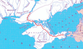
|
map of the canal | |
| Specifications | |
| Length | 250.1 miles (402.5 km) |
| History | |
| Date of act | September 21, 1950 |
| Construction began | 1961 |
| Date completed | December 29, 1975 |
| Geography | |
| Start point | Tavriysk |
| End point | Kerch |
| Connects to | Dnieper River |
The North Crimean Canal (Russian: Северо-Крымский канал, Ukrainian: Північно-Кримський канал) is a land improvement canal for irrigation and watering of Kherson Oblast in southern Ukraine, and the Crimean peninsula. The canal was constructed between 1961 and 1971 and has multiple branches.
Overview
The canal begins at the city of Tavriysk, where it draws from the Kakhovka Reservoir, and stretches out in a generally southeasterly direction, terminating at the small village of Zelnyi Yar (Lenine Raion); from there, a pipeline carries water to supply the city of Kerch at the eastern extreme of the Crimean peninsula. Seven water reservoirs lie along the main canal, which is 402.6 km (250.2 mi) in length. Water flows by gravity from Tavriysk to Dzhankoy, where it is elevated by four pump stations to a height of over 100 m (330 ft) to energize its continued downstream flow. In Crimea, numerous smaller canals branch off the main channel, including the Razdolne rice canal, Azov rice canal, Krasnohvardiiske distribution canal, Uniting canal, and Saky canal; through these, water is also supplied to the city of Simferopol.[1]
The idea of construction of canal were raised in the 19th century, particularly the Russian-Finnish botanist Christian von Steven. But it was not until after the World War II when the decision was finally adopted on September 21, 1950 by the Central Committee of the Communist Party of the Soviet Union and the Government of the Soviet Union. The decision was to build the Kakhovka Hydro Electric Station, South Ukrainian and North Crimean canals. In 1951 the Soviet postal service released a commemorating post stamp where the North Crimean Canal was categorized as the Great Construction Projects of Communism.
After the Russian annexation of Crimea during the 2014 Crimean crisis, Ukrainian authorities greatly reduced the volume of water flowing into Crimea via the canal, threatening the viability of the peninsula's agricultural crops, which are heavily dependent on irrigation.[2] One of the reasons for reduction of the water supply is because of the accumulation of a huge debt.[2] Another source claims that there is water in canal, but Russian turned the pumps off on purpose for political reasons.[3]
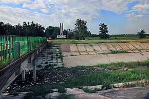
Gallery
-
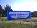
Sign with information about the canal
Branches
Kherson Oblast
- Kakhovka Canal
- Krasnoznamensky Canal
Crimea
- Razdolne Rice Canal
- Azov Rice Canal
- Uniting Canal
- Saky Canal
- Krasnohvardiyske distribution branch
Water reservoirs
- Mizhhirne
- Feodosiyske
- Frontove
- Leninske
- Samarlynske
- Starokrymske
- Stantsiyne (Kerchenske)
External links
- Berezovsky, E. Северо-Крымский - дорога куда? (North-Crimean is road to where?). "Ekologiya i Mir" (Crimean Republican Association).
- Nina Bogutskaya, Jennifer Hales Crimean Peninsula. Freshwater Ecoregions of the World.
References
- ↑ Tymchenko, Z. North Crimean Canal. History of construction. Ukrayinska Pravda. May 13, 2014 (Krymskiye izvestiya. November 2012)
- ↑ 2.0 2.1 "Russia fears Crimea water shortage as supply drops". BBC News. 2014-04-25. Retrieved 2014-04-26.
- ↑ Anonymous explained that the Russian authorities turned off water in Crimea. Ukrayinska Pravda. 27 April 2014
Coordinates: 46°45′52″N 33°23′41″E / 46.76444°N 33.39472°E