North Carolina Highway 280
| ||||
|---|---|---|---|---|
| Route information | ||||
| Maintained by NCDOT | ||||
| Length: | 18.16 mi[1] (29.23 km) | |||
| Existed: | 1931[2] – present | |||
| Major junctions | ||||
| South end: |
| |||
|
| ||||
| North end: |
| |||
| Location | ||||
| Counties: | Transylvania, Henderson, Buncombe | |||
| Highway system | ||||
| ||||

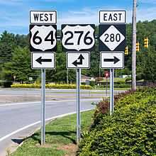
North Carolina Highway 280 (NC 280) is a state highway in western North Carolina that runs from the town of Fletcher in Henderson County to the city of Brevard in Transylvania County. It is 18 miles (29 km) in length, starting at the intersection with US 64 and US 276 north of Brevard to US 25 and US 25A in Arden.
Route description
NC 280 begins at the junction of US 64 and US 276 near the city of Brevard. It then travels northeasterly through the unincorporated community of Pisgah Forest as a 4-lane highway before crossing Little Mountain and entering the Boyd Township community, where it widens to four-lanes with a center turning lane. It runs for a total of 5.2 miles (8.4 km) through Transylvania County as Asheville Highway before entering Henderson County, at which point it becomes Boylston Highway. It continues as a four-lane highway with a center turning lane for 6.1 miles (9.8 km) through rural Northwestern Henderson County before intersecting NC 191 (Haywood Road) in the town of Mills River. NC 280 and NC 191 run concurrently for 1.1 miles (1.8 km). After crossing the Mills River, a tributary of the French Broad River, NC 191 turns north onto Old Haywood Road, and NC 280 continues as a divided 4-lane, limited-access highway for 3 miles (4.8 km). After crossing the French Broad River, the highway enters Buncombe County and becomes New Airport Road at the intersection of Fanning Bridge Road in Fletcher, where it resumes the configuration of four-lanes with a center turning lane. It then crosses I-26/US 74 at Exit 40 and continues for another 1.9 miles (3.1 km), terminating at the intersection of US 25 (Hendersonville Road) and US 25A (Sweeten Creek Road) in Arden. Although the highway runs primarily through rural farming and residential areas for most of its length, the stretch between Fanning Bridge Road and US 25 currently represents the most developed section of the highway. A growing number of national retailers, restaurants, and hotels can be found within a half-mile of the I-26/US 74 interchange.[3][4] Landmarks along this section of highway include Asheville Regional Airport and the WNC Agricultural Center, site of the annual NC Mountain State Fair.
For 10.1 miles (16.3 km) of its path through Transylvania and Henderson counties, the highway runs adjacent to the eastern boundary of Pisgah National Forest.
History
Rerouted from its original path to become a connecting route from I-26 at the Asheville Regional Airport to the city of Brevard, its expanded and current form was originally known as the Brevard/I-26 Connector. Until 1991, NC 280 ran concurrent with NC 191 from Mills River in Henderson County to the community of Avery Creek in Buncombe County, at which point NC 280 turned onto Long Shoals Road (currently signed NC 146). The former eastern terminus of NC 280 was at US 25 (Hendersonville Road) in the community of Skyland, 1.9 miles north of the highway's current terminus at US 25 and US 25A in Arden.
Major intersections
| County | Location | mi | km | Destinations | Notes |
|---|---|---|---|---|---|
| Transylvania | Brevard | 0.00 | 0.00 | To Brevard College and Cradle of Forestry | |
| Henderson | Mills River | 11.32 | 18.22 | South end of NC 191 overlap | |
| 12.46 | 20.05 | North end of NC 191 overlap | |||
| Buncombe | Fletcher | 16.15 | 25.99 | ||
| Arden | 18.16 | 29.23 | |||
| 1.000 mi = 1.609 km; 1.000 km = 0.621 mi | |||||
References
- ↑ Overview Map North Carolina Route 280 (Map). Yahoo Maps. Retrieved 2009-01-21.
- ↑ N.C. 280 (Map). The NCRoads.com Annex. Retrieved 2010-01-24.
- ↑ Kelley, Leigh (15 October 2007). "Business Thriving Near Airport". Times-News. Retrieved 12 October 2013.
- ↑ Boyle, John (14 September 2013). "Airport Road Growth Picks Up Pace". Citizen-Times. Retrieved 12 October 2013.
External links
-
 Media related to North Carolina Highway 280 at Wikimedia Commons
 - NCRoads.com: N.C. 280