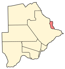
North-East District (Botswana)
| North-East | |
|---|---|
| District | |
 Location within Botswana | |
| Coordinates: 21°5′S 27°30′E / 21.083°S 27.500°ECoordinates: 21°5′S 27°30′E / 21.083°S 27.500°E | |
| Country |
|
| Capital | Francistown |
| Area | |
| • Total | 5,120 km2 (1,980 sq mi) |
| Population (2013 census) | |
| • Total | 167,500 |
| • Density | 33/km2 (85/sq mi) |
| Time zone | Central Africa Time (UTC+2) |
The North-East District is one of the administrative districts of Botswana. Its capital is Francistown. In 2013, North-East had a population of 167,500 people. The North-East District is predominantly occupied by Kalanga speaking people (the BaKalanga).
In the north and east, North-East borders the Matabeleland South Province of Zimbabwe with the border in the east predominantly the Ramokgwebana River Center. In the south and west, North-East District borders Central District and the border being the Shashe River Center.
Sub-districts
- Francistown
- North East
Villages
In the 2011 Census[1] these villages were listed: Botalaote, Butale, Ditladi, Gambule, Gulubane, Gungwe, Jackalas 1, Jackalas No 2, Kalakamati, Kgari, Letsholathebe, Mabudzane, Makaleng, Mambo, Mapoka, Masingwaneng, Masukwane, Masunga, Matenge, Matopi, Matshelagabedi, Matsiloje, Mbalambi, Moroka, Mosojane, Mowana, Mulambakwena, Nlakhwane, Patayamatebele, Pole, Ramokgwebana, Sechele, Sekakangwe, Senyawe, Shashe Bridge, Siviya, Tati Siding, Themashanga, Toteng, Tsamaya, Tshesebe, Vukwi, Zwenshambe.
Geography
The Nata River flows through the North-East District and is a significant gathering place for wildlife including birds.[2] The Nata River continues to flow to the Makgadikgadi Pans, where it discharges.[3]
See also
References
- Elizabeth Cashdan (1986) Competition between Foragers and Food-Producers on the Botletli River, Botswana, Africa: Journal of the International African Institute, Vol. 56, No. 3, pp. 299-318
- C. Michael Hogan (2008) Makgadikgadi, The Megalithic Portal, ed. Andy Burnham
Line notes
- ↑ "2011 Botswana Population and Housing Census" (PDF). Retrieved 2013-09-11.
- ↑ Elizabeth Cashdan, 1986
- ↑ C. Michael Hogan, 2008