Norfolk Island National Park
| Norfolk Island National Park Norfolk Island | |
|---|---|
|
IUCN category II (national park) | |
|
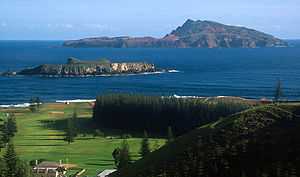
Captain Cook lookout within the Norfolk Island National Park | |
|
View across to the larger Phillip Island in the distance. In the foreground is the smaller Nepean Island | |
 Norfolk Island National Park | |
| Nearest town or city | Burnt Pine |
| Coordinates | 29°04′S 167°56′E / 29.067°S 167.933°ECoordinates: 29°04′S 167°56′E / 29.067°S 167.933°E |
| Established | 1984 |
| Area | 6.5 km2 (2.5 sq mi) |
| Managing authorities | Australian Government Department of the Environment |
| Website | Norfolk Island National Park |
Norfolk Island National Park is a protected area of 6.50 km² established in 1984 and managed by the Commonwealth of Australia. It comprises two sections, the Mount Pitt section on Norfolk Island in the South Pacific Ocean with an area of 4.60 km² and the neighbouring 1.90 km² Phillip Island, as well as the much smaller Nepean Island. The Norfolk Island group is an Australian territory and the park is managed by Parks Australia. It is the only place in the world where the Norfolk Island Parakeet and the White-chested White-eye occur.
Management aims for the Norfolk Island National Park are to:
- protect and restore populations of native plants and animals, natural ecosystems and ecological processes, and to provide for appropriate recreational opportunities for Norfolk Island residents and visitors.
References
- Anon. (2000). Norfolk Island National Park and Norfolk Island Botanic Garden. Plans of Management. Environment Australia: Canberra. ISBN 0-642-54667-3

