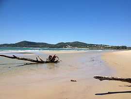
Noosa North Shore, Queensland
| Noosa North Shore Noosa, Queensland | |||||||||||||
|---|---|---|---|---|---|---|---|---|---|---|---|---|---|
|
Beach at North Shore, Queensland looking south towards Noosa Heads | |||||||||||||
| Population | 121 (2006 census)[1] | ||||||||||||
| • Density | 4.0/km2 (10.4/sq mi) | ||||||||||||
| Postcode(s) | 4565 | ||||||||||||
| Area | 30 km2 (11.6 sq mi) | ||||||||||||
| Location | 2 km (1 mi) NW of Noosa Heads | ||||||||||||
| LGA(s) | Shire of Noosa | ||||||||||||
| State electorate(s) | Noosa | ||||||||||||
| Federal Division(s) | Wide Bay | ||||||||||||
| |||||||||||||
Coordinates: 26°16′23″S 153°03′04″E / 26.273°S 153.051°E
Noosa North Shore is a suburb in Noosa, Queensland, Australia.[2] It is within the local government area of Shire of Noosa (between 2008 and 2013 it was within Sunshine Coast Region).
Geography
It contains part of the Great Sandy National Park and the small town of Teewah. The name of the suburb refers to its location on the northern banks of the Noosa River.
The suburb is the southern end point of the Cooloola Great Walk.[3]
Access to the suburb is provided by the cable ferry, Noosa River Ferry, which crosses the Noosa River at Tewantin.
References
- ↑ Australian Bureau of Statistics (25 October 2007). "North Shore (Noosa Shire) (State Suburb)". 2006 Census QuickStats. Retrieved 19 March 2008.
- ↑ "Noosa North Shore (entry 47233)". Queensland Place Names. Queensland Government. Retrieved 26 April 2014.
- ↑ Jo Skinner (29 March 2010). "$1.3m Cooloola Great Walk opens". ABC News. Retrieved 22 July 2010.
External links
| Wikimedia Commons has media related to Noosa North Shore, Queensland. |
