Nong Hong District
| Nong Hong หนองหงส์ | |
|---|---|
| Amphoe | |
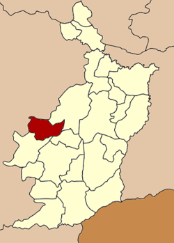 Amphoe location in Buriram Province | |
| Coordinates: 14°51′0″N 102°41′18″E / 14.85000°N 102.68833°ECoordinates: 14°51′0″N 102°41′18″E / 14.85000°N 102.68833°E | |
| Country |
|
| Province | Buriram |
| Seat | Sa Kaeo |
| Area | |
| • Total | 335.0 km2 (129.3 sq mi) |
| Population (2005) | |
| • Total | 48,442 |
| • Density | 144.6/km2 (375/sq mi) |
| Time zone | THA (UTC+7) |
| Postal code | 31240 |
| Geocode | 3114 |
Nong Hong (Thai: หนองหงส์) is a district (Amphoe) in the western part of Buriram Province, northeastern Thailand.
Geography
Neighboring districts are (from the northeast clockwise) Lam Plai Mat, Chamni, Nong Ki of Buriram Province, Chakkarat and Huai Thalaeng of Nakhon Ratchasima Province.
History
The minor district (King Amphoe) was created on Match 31 1981, when the three tambon Sa Kaeo, Huai Hin and Thai Samakkhi were split off from Lam Plai Mat district.[1] It was upgraded to a full district on January 1, 1988.[2]
Administration
The district is subdivided into 7 subdistricts (tambon), which are further subdivided into 100 villages (muban). Nong Hong is a township (thesaban tambon) which covers parts of tambon Sa Kaeo. There are also 7 Tambon administrative organizations (TAO).
| No. | Name | Thai name | Villages | Inh. | |
|---|---|---|---|---|---|
| 1. | Sa Kaeo | สระแก้ว | 15 | 6,633 | |
| 2. | Huai Hin | ห้วยหิน | 19 | 9,573 | |
| 3. | Thai Samakkhi | ไทยสามัคคี | 15 | 8,885 | |
| 4. | Nong Chai Si | หนองชัยศรี | 15 | 6,079 | |
| 5. | Sao Diao | เสาเดียว | 15 | 6,616 | |
| 6. | Mueang Fai | เมืองฝ้าย | 12 | 7,031 | |
| 7. | Sa Thong | สระทอง | 9 | 3,625 |
References
- ↑ ประกาศกระทรวงมหาดไทย เรื่อง แบ่งท้องที่อำเภอลำปลายมาศ จังหวัดบุรีรัมย์ ตั้งเป็นกิ่งอำเภอหนองหงส์. Royal Gazette (in Thai) 98 (47 ง): 1091. April 21, 1981.
- ↑ พระราชกฤษฎีกาตั้งอำเภอนามน อำเภอพระยืน อำเภอหนองบัวระเหว อำเภอบ้านเหลื่อม อำเภอจะแนะ อำเภอหนองหงส์ อำเภอนาโพธิ์ อำเภอเกาะยาว อำเภอแกดำ อำเภอสระโบสถ์ อำเภอโนนคูณ อำเภอควนโดน อำเภอไชยวาน อำเภอหนองแสง และอำเภอตาลสุม พ.ศ. ๒๕๓๐. Royal Gazette (in Thai) 104 (278 ก special): 33–37. December 31, 1987.