Nock Mountains
| Nock Mountains | |
|---|---|
|
Alpine landscape in the Nock Mountains national park | |
| Highest point | |
| Peak | Eisenhut |
| Elevation | 2,441 m (8,009 ft) |
| Dimensions | |
| Length | 10 km (6.2 mi) |
| Geography | |
| State | Carinthia, Salzburg, Styria |
| Range coordinates | 46°54′N 13°44′E / 46.9°N 13.73°ECoordinates: 46°54′N 13°44′E / 46.9°N 13.73°E |
| Parent range | Gurktal Alps |
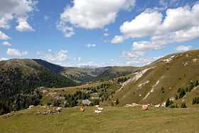
The Nock Mountains[1][2][3] (German: Nockberge or Nockgebirge) are the westernmost and highest mountain range of the Gurktal Alps in Austria, spread over parts of the federal states of Carinthia, Salzburg and Styria. Their appearance is characterised by numerous dome-like and grass-covered summits (Nocken). Their highest peak is Mt. Eisenhut in Styria which reaches an elevation of 2,441 m above sea level (AA). The central area forms the Nock Mountains national park.
Geography
As westernmost part of the Gurktal Alps, the Nock Mountains are separated from the Low Tauern in the north, stretching as far as the Katschberg Pass (1,641 m above sea level (AA)) in the west, by the Mur River. In the west, the rivers Lieser and Drau separate the Nock Mountains from the Ankogel Group of the High Tauern and from the Gailtal Alps. South of Lake Ossiach they are adjoined by the lower Sattnitz range and the Klagenfurt Basin, another part of the Gurktal Alps. To the east, within the Gurktal Alps they are bounded by a line from Gurk via Flattnitz Pass (1,400 m above sea level (AA)) to the Paalbach stream.
The Nock Mountains may be divided into eight subgroups. South of Bad Kleinkirchheim are the stocks of the Mirnock massif (2,110 m above sea level (AA)) with a significant topographic prominence of 1,343 m, the Wöllaner Nock (2,145 m above sea level (AA)) and the Gerlitzen (1,909 m above sea level (AA)) high above Lake Ossiach. The central region of the Nock Mountains is formed by the Millstätter Alpe (2,101 m above sea level (AA)) and the Rosennock (2,440 m above sea level (AA)), the highest summit in Carinthia. In the north are the stocks of the Schwarzwand (2,241 m above sea level (AA)), the Königstuhl (2,406 m above sea level (AA)) in Salzburg, which is also a tripoint, and the Eisenhut (2,441 m above sea level (AA)).
The range has also been referred to in German language tourist brochures as the "Nocky Mountains", an allusion to the Rocky Mountains.[4][5]
National park
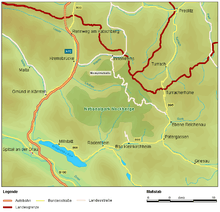
Despite its name, the Nationalpark Nockberge is a protected landscape (Category V) according to IUCN protected area categories. The territory of 184 square kilometres (71 sq mi) is entirely located within the Carinthian part of the range, along the border with Salzburg and Styria, stretching from Krems and the Lieser Valley in the west to Reichenau in the east, and down to Bad Kleinkirchheim and Radenthein in the south.
The park was established by the Carinthian state government on 1 January 1987. The remote area had already been developed with the construction of the scenic Nockalm Road from 1979. Further plans for a skiing region were averted by a citizens' initiative and a referendum in 1980, whereby 94% of the voters declared themselves against the project.
In recent years several attempts have been made to turn the region into a Biosphere park and to elevate the protected landscape to an actual national park according to IUCN categories.
References
- ↑ Lichtenberger, Elisabeth (2000). Austria, Austrian Academy of Science Press, pp. 138, 152 and 490. ISBN 978-3-7001-2775-8.
- ↑ Borntraeger, Gebrüder (1987). Monograph Series on Mineral Deposits, Issues 27-28, p. 220.
- ↑ Bedeker, K. (1970). Austria, Baedekers Autoführer-Verlag, p 140.
- ↑ For example: www.merian.de, www.nockalmstrasse.at, www.speick.de (pdf; 579 kB), www.bz-berlin.de, www.wienerzeitung.at
- ↑ For example: www.merian.de, www.nockalmstrasse.at, www.speick.de (pdf; 579 kB), www.bz-berlin.de, www.wienerzeitung.at
External links
| Wikimedia Commons has media related to Nockberge. |